Blog
River Valley Formation: Complete Guide to Fluvial Landforms & Geomorphology

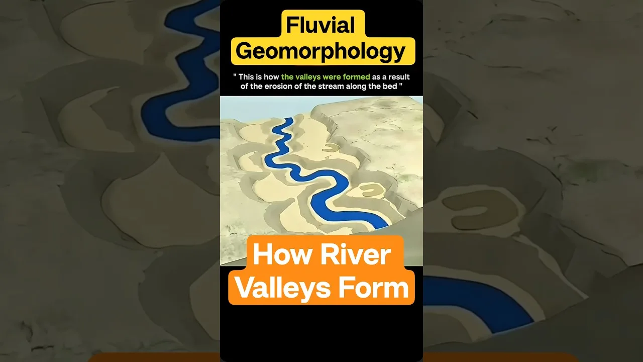
Table of Contents
- The Core Mechanisms Driving River Valley Formation
- Vertical Erosion: The Youthful Sculptor
- Lateral Erosion: The Valley Widener
- Three Stages of River Valley Development
- Youthful Stage: Steep Gradients and V-Shaped Profiles
- Mature Stage: Meanders, Floodplains, and Valley Widening
- Old Stage: Depositional Dominance and Deltaic Termination
- Controlling Factors in River Valley Formation
- River Energy: Gradient, Discharge, and Sediment Load
- Rock Resistance and Structural Control
- Climate: Arid vs. Humid Regimes
- Tectonic and Base Level Forcing
- Human Significance and Exam Relevance
- Modern Research Frontiers
River valley formation represents one of Earth’s most fundamental geomorphological processes, shaping landscapes across every continent through the persistent action of flowing water over geological timescales. Understanding how river valleys develop provides critical insights for geography students, competitive exam aspirants, and anyone fascinated by the dynamic forces sculpting our planet’s surface. This comprehensive guide explores the mechanisms, stages, and controlling factors behind valley evolution, from youthful V-shaped gorges to mature floodplains and ancient deltaic systems.
- River valley formation occurs through three primary processes: erosion, transportation, and deposition of sediment by flowing water.
- Vertical erosion dominates early stages creating V-shaped valleys; lateral erosion widens valleys in mature stages forming floodplains.
- Three distinct developmental stages exist: youthful (steep, V-shaped), mature (meandering, floodplains), and old (wide, depositional, deltas).
- Key controlling factors include river energy (gradient/discharge), rock resistance (lithology), and climate (arid vs. humid regimes).
- Classic examples include the Grand Canyon (youthful), Mississippi River middle course (mature), and Nile Delta (old stage).
- These landforms are vital for human civilization providing fertile soils, water resources, transportation corridors, and settlement sites.
The Core Mechanisms Driving River Valley Formation
The process of river valley formation begins when precipitation accumulates as surface runoff or groundwater discharge, initiating channelized flow downhill. The erosive power of this flow—quantified by stream power (Ω = ρgQS, where ρ is water density, g is gravity, Q is discharge, and S is channel slope)—determines the rate and style of landscape dissection. Two distinct erosional modes operate simultaneously but with shifting dominance throughout a river’s lifecycle.
Vertical Erosion: The Youthful Sculptor
In the initial phase of river valley formation, vertical erosion (downcutting) prevails. High gradients generate rapid flow velocities, enabling the river to pluck and abrade bedrock directly beneath river valley formation. This process creates the characteristic V-shaped cross-profile with steep, convex valley sides. Hydraulic action, abrasion (corrasion), and solution work in concert: hydraulic pressure fractures jointed rock, sediment tools grind the channel bed, and chemical weathering weakens resistant strata. Notable landforms include waterfalls, rapids, plunge pools, and interlocking spurs where the channel winds around resistant ridges. The Grand Canyon of the Colorado River exemplifies extreme vertical incision, exposing nearly two billion years of geological strata across a 1.6 km depth.
Lateral Erosion: The Valley Widener
As base level is approached and gradient decreases, the river’s energy redirects laterally. Meandering channels develop helical flow patterns—fastest velocity shifts toward the outer bank (cut bank), causing undercutting and mass wasting, while slower inner-bank flow deposits point bars. This lateral migration widens the valley floor, creating a flat floodplain composed of alluvium. Bluffs or valley walls mark the boundary between the active floodplain and older terrace surfaces. The Mississippi River’s middle course demonstrates classic meander geometry with wavelengths 10-14 times channel width, migrating laterally at rates up to 100 meters per year in unconsolidated sediments. – a key consideration for river valley formation.
Three Stages of River Valley Development
Geomorphologists classify river valley formation into a temporal sequence—youthful, mature, and old stages—though real rivers exhibit spatial zonation along their longitudinal profile. This Davisian cycle of erosion, refined by Penck and Hack, remains foundational in physical geography curricula worldwide.
Youthful Stage: Steep Gradients and V-Shaped Profiles
- Gradient: High (> 5 m/km), often exceeding 10 m/km in mountainous headwaters
- Valley Cross-Section: Narrow, symmetrical V-shape with no floodplain
- Dominant Process: Vertical erosion (downcutting) >> lateral erosion
- Channel Pattern: Straight to slightly sinuous, bedrock-controlled
- Key Landforms: Waterfalls, rapids, gorges, interlocking spurs, plunge pools
- Sediment Load: Coarse bedload (boulders, cobbles); minimal suspended load
- Classic Example: Upper Colorado River through Grand Canyon; Indus River gorge near Nanga Parbat (7 km relief)
In youthful valleys, the river occupies the entire valley floor. Weathering of valley sides (mass wasting, soil creep) supplies debris that the stream must evacuate, maintaining steep side slopes near the angle of repose (30-35°). Knickpoints—abrupt gradient changes marking lithological boundaries or tectonic uplift—migrate upstream as waterfalls retreat. – a key consideration for river valley formation.
Mature Stage: Meanders, Floodplains, and Valley Widening
- Gradient: Moderate (0.5-5 m/km)
- Valley Cross-Section: Asymmetrical with distinct floodplain (width 10-100x channel width)
- Dominant Process: Lateral erosion ≈ vertical erosion; deposition on point bars
- Channel Pattern: Meandering (sinuosity > 1.5), braided in high-sediment regimes
- Key Landforms: Meander loops, cut banks, point bars, slip-off slopes, bluffs, terraces
- Sediment Load: Mixed bedload and suspended load; floodplain aggradation during overbank flow
- Classic Example: Middle Mississippi River (Cairo, IL to St. Louis, MO); Ganga River through Indo-Gangetic Plain
Mature valleys achieve maximum width-to-depth ratios. Floodplains form through lateral accretion (point bar migration) and vertical accretion (overbank silt/clay deposition). Natural levees—coarse sediment berms parallel to river valley formation—elevate the channel above the floodplain, creating backswamp environments. Oxbow lakes form when meander necks cutoff during floods, abandoning the loop. The Mississippi’s meander belt spans 5-10 km width, with historical migration rates documented since the 1765 surveys of Captain Ross.
Old Stage: Depositional Dominance and Deltaic Termination
- Gradient: Very low (< 0.5 m/km), often < 0.1 m/km near base level
- Valley Cross-Section: Extremely wide (10-100 km), minimal relief
- Dominant Process: Deposition >> erosion; channel aggradation and avulsion
- Channel Pattern: Highly sinuous meanders, anastomosing, or distributary networks
- Key Landforms: Extensive floodplains, oxbow lakes, yazoo tributaries, deltas, estuaries
- Sediment Load: Predominantly suspended load (silt/clay); bedload minimal
- Classic Example: Lower Nile River (Cairo to Mediterranean); Lower Amazon; Mississippi Delta
Old-stage valleys approach graded equilibrium where sediment transport capacity matches supply. The Nile’s floodplain near Cairo spans 15-20 km width, sustained by annual inundation cycles that deposited nutrient-rich silt for millennia—earning Herodotus’ epithet “gift of the Nile.” Modern dams (Aswan High Dam, 1970) have disrupted this cycle, causing delta subsidence and coastal erosion at rates up to 10 m/year. Delta formation represents the terminal phase of river valley formation, where fluvial processes transition to marine influence, creating distributary networks, levees, crevasse splays, and prodelta clays.
Controlling Factors in River Valley Formation
While the stage model provides a useful framework, actual valley morphology reflects the interplay of multiple independent variables. Understanding these controls is essential for predicting valley response to environmental change.
River Energy: Gradient, Discharge, and Sediment Load
The stream power equation (Ω = ρgQS) quantifies the energy available for erosion. High-gradient, high-discharge rivers (e.g., Himalayan rivers: Indus, Brahmaputra, Sutlej) maintain youthful characteristics far downstream due to tectonic uplift outpacing incision. Conversely, low-gradient rivers on stable cratons (e.g., Russian Platform rivers: Volga, Dnieper) achieve maturity rapidly. Sediment load modulates efficiency: tools effect (sediment enhances abrasion) vs. cover effect (excess sediment armors bed). The Yellow River (Huang He) carries ~1.6 Gt/yr sediment load—the world’s highest—creating a perched channel above the North China Plain, requiring continuous levee heightening since 602 CE.
Rock Resistance and Structural Control
Lithology exerts first-order control on river valley formation. Resistant units (quartzite, granite, basalt) form narrow gorges, waterfalls, and knickpoints; weak units (shale, limestone, unconsolidated sediments) widen rapidly. Structural geology directs valley orientation: joints, faults, and fold axes create rectilinear drainage patterns (trellis, angular). The Appalachian Valley-and-Ridge province exemplifies structural control—rivers follow strike valleys in shale (e.g., Shenandoah Valley) while water gaps breach resistant sandstone ridges (e.g., Delaware Water Gap). Differential erosion across dipping strata creates cuesta landscapes with asymmetric valleys (dip slopes vs. scarp slopes).
Climate: Arid vs. Humid Regimes
Climate modulates weathering intensity, runoff regime, and vegetation cover—all affecting river valley formation. Arid regions (Atacama, Sahara, Central Australia) experience infrequent, high-magnitude flash floods producing steep, discontinuous channels with alluvial fans at mountain fronts. Chemical weathering is minimal; mechanical disintegration dominates. Humid tropics (Amazon, Congo, Southeast Asia) sustain perennial flow, deep chemical weathering (lateritic soils), and dense vegetation stabilizing banks—promoting meandering channels and wide floodplains. Temperate zones exhibit seasonal discharge variability driving distinct morphologies. Glacial legacy complicates matters: post-glacial rivers (e.g., Great Lakes drainage, Scandinavian rivers) inherit overdeepened valleys, hanging tributaries, and abundant sediment, creating disequilibrium conditions persisting for 10⁴-10⁵ years.
Tectonic and Base Level Forcing
Beyond climate and lithology, tectonics and base level changes drive valley evolution over longer timescales. Base level—the lowest elevation to which a river can erode—acts as the ultimate control. Eustatic sea-level fluctuations (120 m amplitude during Quaternary glacial cycles) force upstream knickpoint migration and valley incision/aggradation cycles. The Mississippi River incised 30-40 m during the Last Glacial Maximum (lowstand ~20 ka), then aggraded during Holocene transgression, creating the modern valley fill sequence. Tectonic uplift (e.g., Himalaya: 5-10 mm/yr; Andes: 1-3 mm/yr) rejuvenates valleys, creating strath terraces—abandoned valley floors recording episodic incision. The Yellow River’s terraces in the Lanzhou region record 8 incision events over 1.2 Ma, correlating with Tibetan Plateau uplift phases.
Human Significance and Exam Relevance
River valleys have cradled civilization since the Neolithic. The Fertile Crescent (Tigris-Euphrates), Indus Valley (Harappa), Yellow River (Yangshao), and Nile Valley (Ancient Egypt) all emerged on fertile floodplains with reliable water. Today, > 2.5 billion people inhabit river basins covering 20% of global land area. Understanding river valley formation informs flood hazard mapping, dam siting, navigation channel maintenance, and ecosystem restoration. For competitive examinations (UPSC, CUET, UGC-NET, State PSCs), fluvial geomorphology constitutes 15-20% of physical geography syllabi. Key concepts tested include: Davis vs. Penck erosion cycles, valley cross-profiles, rejuvenation features (terraces, knickpoints, incised meanders), drainage patterns, and applied aspects (flood management, river training works). The National Council of Educational Research and Training (NCERT) Class 11 “Fundamentals of Physical Geography” Chapter 7 and Class 12 “India: Physical Environment” provide authoritative curriculum coverage.
Modern Research Frontiers
Contemporary geomorphology employs LiDAR, cosmogenic nuclide dating (¹⁰Be, ²⁶Al), and numerical landscape evolution models (CHILD, FastScape, Landlab) to quantify river valley formation rates and test theoretical predictions. Studies reveal non-linear responses to climate forcing, threshold-dependent incision, and the role of extreme events (outburst floods, megafloods) in rapid valley excavation. The Channeled Scablands of Washington State—carved by Missoula Floods (15-13 ka, peak discharge ~10⁷ m³/s)—demonstrate that catastrophic events can accomplish in days what gradual erosion requires millennia. Such insights reshape our understanding of Martian valley networks, where similar megaflood features suggest episodic aqueous activity.
Mastering the principles of river valley formation equips students and professionals to interpret landscapes dynamically—recognizing that every valley tells a story of rock, water, time, and tectonics written in the language of geomorphology. For daily geography insights and exam-oriented resources, follow The Geoecologist and explore authoritative references like the Wikipedia article on river valleys and the USGS Water Science School.
Frequently Asked Questions
The three main stages are youthful (steep gradient, V-shaped valley, vertical erosion dominant), mature (moderate gradient, meandering channel, floodplain development, lateral erosion dominant), and old stage (very low gradient, wide valley, extensive floodplains, oxbow lakes, delta formation, deposition dominant).
Vertical erosion (downcutting) deepens the channel, creating V-shaped valleys in youthful stages. Lateral erosion (sidecutting) widens the valley by undercutting banks, forming floodplains and meanders in mature stages. Both processes operate simultaneously but with shifting dominance.
Key controls include river energy (gradient × discharge), rock resistance (lithology and structure), climate (arid vs. humid weathering regimes), tectonic uplift/subsidence, and base level changes (sea-level fluctuations). These factors interact to produce diverse valley morphologies worldwide.