Blog
Western Ghats Formation: Geological History, Biodiversity & UPSC Significance

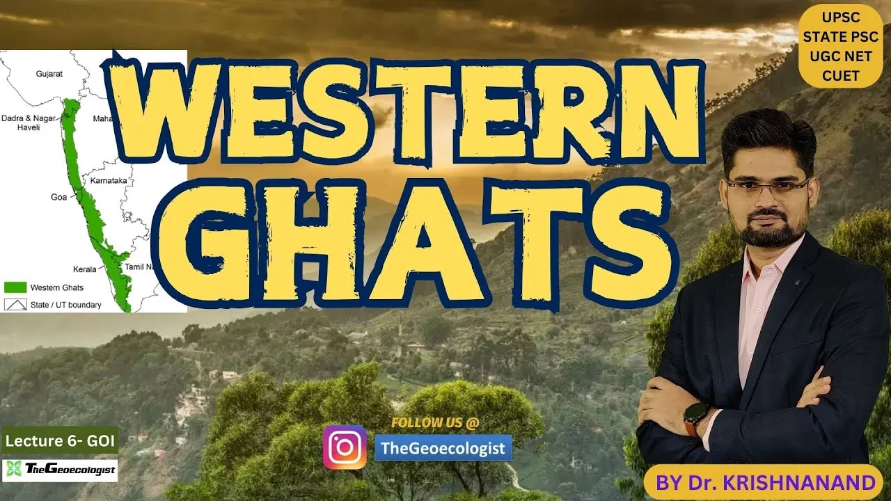
Table of Contents
- Geological Timeline of Western Ghats Formation
- Gondwana Breakup and India's Northward Journey
- Réunion Hotspot and the Deccan Traps Event
- Post-Volcanic Uplift and Escarpment Development
- Physical Characteristics Shaped by Western Ghats Formation
- The Great Escarpment and Orographic Rainfall
- Watershed Functions and River Systems
- Biodiversity: Evolutionary Consequences of Western Ghats Formation
- Endemism Hotspot and Species Radiation
- Sky Islands and Montane Speciation
- Ecological Significance and Conservation Challenges
- Climate Regulation and Carbon Sequestration
- Anthropogenic Threats and Fragmentation
- Conservation Frameworks and Policy Response
- UPSC Examination Relevance: Western Ghats Formation Topics
- Geography (GS Paper I)
- Environment & Ecology (GS Paper III)
- Prelims Focus Areas
- Conclusion: Stewardship of a Geological Masterpiece
The Western Ghats formation represents one of Earth’s most remarkable geological narratives, spanning over 150 million years of tectonic drama, volcanic fury, and evolutionary brilliance. Stretching 1,600 kilometers along India’s western coastline, this UNESCO World Heritage Site traverses six states—Gujarat, Maharashtra, Goa, Karnataka, Tamil Nadu, and Kerala—serving as a living laboratory for geologists, ecologists, and UPSC aspirants alike. Understanding the Western Ghats formation process unlocks critical insights into plate tectonics, biodiversity hotspots, and India’s monsoon dynamics.
- The Western Ghats originated during the breakup of Gondwana supercontinent approximately 150 million years ago
- Massive volcanic eruptions from the Réunion hotspot 66 million years ago created the Deccan Traps
- Tectonic uplift and differential erosion sculpted the characteristic steep western escarpment
- The range hosts over 7,400 flowering plant species and 500+ animal species with high endemism
- It acts as a critical watershed feeding major peninsular rivers: Godavari, Krishna, Kaveri
- Conservation challenges include deforestation, mining, and climate change impacts
Geological Timeline of Western Ghats Formation
Gondwana Breakup and India’s Northward Journey
The story of Western Ghats formation begins in the Late Jurassic period, roughly 150-160 million years ago, when the supercontinent Gondwana began fragmenting. The Indian plate, once joined with Africa, Antarctica, Australia, and South America, started its dramatic northeastward drift at velocities reaching 15-20 cm per year—exceptionally fast for tectonic movement. As India separated from Madagascar around 88 million years ago, the western margin of the Indian plate experienced extensive rifting, creating the foundational structural grain that would later define the Ghats’ orientation.
This rifting phase thinned the continental crust along India’s western margin, establishing a passive continental margin characterized by fault-bounded basins and horst-graben structures. The Western Ghats owe their fundamental north-south alignment to these Precambrian structural trends reactivated during Gondwana dispersal.
Réunion Hotspot and the Deccan Traps Event
The most cataclysmic chapter in Western Ghats formation unfolded approximately 66 million years ago when the Indian plate traversed the Réunion mantle plume. This hotspot interaction triggered one of Earth’s largest continental flood basalt events—the Deccan Traps—erupting an estimated 1.3 million cubic kilometers of lava across 500,000 square kilometers. The eruptions occurred in multiple phases, with the main pulse coinciding precisely with the Cretaceous-Paleogene (K-Pg) boundary, contributing to the mass extinction that eliminated non-avian dinosaurs.
These basalt flows, reaching thicknesses of 2-3 kilometers in places, buried the pre-existing topography and created the vast Deccan Plateau. The western edge of this volcanic plateau would eventually become the Western Ghats escarpment. Geochemical studies of Deccan basalts reveal distinct magma batches, indicating complex mantle dynamics beneath the Réunion plume.
Post-Volcanic Uplift and Escarpment Development
Following the cessation of Deccan volcanism around 60 million years ago, the Western Ghats formation entered its geomorphic phase. Isostatic rebound from the massive volcanic load, combined with continued tectonic forces from the India-Eurasia collision (initiated ~50 Ma), drove regional uplift. The western margin experienced differential uplift rates—higher near the coast, lower inland—creating the pronounced eastward tilt of the Deccan Plateau.
Differential erosion then took center stage. The steep, west-facing escarpment intercepting moisture-laden monsoon winds experienced aggressive headward erosion, while the gentler eastern slopes drained into the Bay of Bengal via longer river systems. This erosional asymmetry amplified the topographic contrast, creating the Ghats’ signature profile: a sheer western face rising 1,000-2,500 meters above the coastal plain, transitioning to a dissected plateau surface eastward.
Physical Characteristics Shaped by Western Ghats Formation
The Great Escarpment and Orographic Rainfall
The Western Ghats formation produced a topographic barrier that fundamentally controls India’s climate. The abrupt escarpment forces the southwest monsoon winds (June-September) to ascend rapidly, causing adiabatic cooling and intense orographic precipitation. Windward locations like Mahabaleshwar (Maharashtra) and Agumbe (Karnataka) receive 4,000-7,000 mm annual rainfall, while leeward regions in the rain shadow receive merely 500-1,000 mm.
This precipitation gradient creates extraordinary ecological zonation within short horizontal distances. The windward slopes support tropical wet evergreen forests, while the leeward side transitions through moist deciduous to dry deciduous and thorn scrub vegetation. The UNESCO World Heritage designation specifically recognizes this climatic-ecological interplay.
Watershed Functions and River Systems
The Western Ghats formation created a drainage divide of continental significance. The narrow coastal strip (50-100 km wide) hosts numerous short, swift west-flowing rivers (Sharavati, Mandovi, Zuari, Periyar, Bharathapuzha) that plunge over the escarpment as spectacular waterfalls—Jog Falls (253 m), Dudhsagar Falls (310 m), Athirappilly Falls (24 m).
Eastward, the gentle plateau slope feeds three major peninsular river systems:
- Godavari (1,465 km) – originates at Trimbakeshwar, Maharashtra
- Krishna (1,400 km) – originates near Mahabaleshwar, Maharashtra
- Kaveri (805 km) – originates at Talakaveri, Karnataka
These rivers sustain agriculture, industry, and urban water supply for over 250 million people across peninsular India. The Ghats’ role as a “water tower” makes their conservation a matter of national water security.
Biodiversity: Evolutionary Consequences of Western Ghats Formation
Endemism Hotspot and Species Radiation
The complex topography and climatic gradients resulting from Western Ghats formation have driven exceptional speciation and endemism. The range hosts approximately 7,402 flowering plant species (5,588 native), of which 2,253 (37%) are endemic. Among vertebrates, endemism reaches 65% for amphibians, 62% for reptiles, 53% for fishes, and 12% for mammals.
Iconic endemic taxa include:
| Taxonomic Group | Endemic Species Examples |
|---|---|
| Mammals | Nilgiri Tahr, Lion-tailed Macaque, Nilgiri Langur, Malabar Civet |
| Birds | Malabar Grey Hornbill, White-bellied Treepie, Nilgiri Flycatcher |
| Amphibians | Purple Frog (Nasikabatrachus sahyadrensis), Munnar Bush Frog, Resplendent Shrub Frog |
| Reptiles | Nilgiri Keelback, Large-scaled Pit Viper, Salea lizards |
| Plants | Neelakurinji (Strobilanthes kunthiana), 1,200+ endemic flowering plants |
The Purple Frog, discovered in 2003, represents a lineage diverged ~130 million years ago—a living fossil from the Gondwanan breakup era, directly linking Western Ghats formation to relictual biodiversity.
Sky Islands and Montane Speciation
High-elevation peaks (>1,800 m) like Anamudi (2,695 m), Doddabetta (2,637 m), and Mullayanagiri (1,930 m) function as “sky islands”—isolated montane habitats separated by warmer lowlands. This insular geography, a direct product of Western Ghats formation topography, drives allopatric speciation. The Nilgiri Hills alone harbor 30% of the Ghats’ endemic plant species within 0.1% of the land area.
The IUCN Western Ghats programme identifies 39 serial sites across seven sub-clusters as critical for conserving this Outstanding Universal Value.
Ecological Significance and Conservation Challenges
Climate Regulation and Carbon Sequestration
Beyond biodiversity, the Western Ghats formation created forests that regulate regional and global climate. The Ghats’ forests store an estimated 1.2-1.5 billion tonnes of carbon, with annual sequestration of 30-40 million tonnes. They modulate the Indian monsoon through evapotranspiration recycling—approximately 25-30% of monsoon rainfall originates from continental moisture recycling, heavily influenced by Ghats’ forest cover.
The Shola-grassland mosaic in the high elevations represents a unique fire-maintained ecosystem storing disproportionate soil carbon. Peat deposits in Nilgiri valleys contain paleoclimate records spanning 20,000+ years.
Anthropogenic Threats and Fragmentation
Despite protected area coverage (~10% of the landscape), the Western Ghats formation legacy faces escalating threats:
- Habitat loss: 35-40% original forest cover lost since 1920s; annual deforestation rate 0.5-0.8%
- Fragmentation: Linear infrastructure (roads, railways, power lines) creates 2,000+ fragments
- Mining: Iron ore (Kudremukh, Goa), bauxite (Maharashtra, Karnataka) scars escarpment
- Invasive species: Lantana camara, Senna spectabilis, Acacia mearnsii dominate understories
- Climate change: Species range shifts upslope; 2-3°C warming projected by 2050
Conservation Frameworks and Policy Response
India’s conservation response operates at multiple scales:
- Legal: Wildlife Protection Act (1972), Forest Conservation Act (1980), Biological Diversity Act (2002)
- Landscape: Nilgiri Biosphere Reserve (1986), Agasthyamalai Biosphere Reserve (2001)
- International: UNESCO World Heritage (2012), Global Biodiversity Hotspot (Myers et al. 2000)
- Science-policy: Western Ghats Ecology Expert Panel (Gadgil Report, 2011), High Level Working Group (Kasturirangan Report, 2013)
The Gadgil-Kasturirangan debates highlight tensions between ecological sustainability and developmental aspirations—a case study in environmental governance relevant for UPSC General Studies Paper III.
UPSC Examination Relevance: Western Ghats Formation Topics
Geography (GS Paper I)
- Plate tectonics: Gondwana breakup, Réunion hotspot, Deccan volcanism
- Geomorphology: Escarpment formation, differential erosion, drainage patterns
- Climatology: Orographic rainfall, monsoon dynamics, rain shadow effect
- Biogeography: Endemism, sky islands, species-area relationships
Environment & Ecology (GS Paper III)
- Biodiversity hotspots criteria and Western Ghats qualification
- Conservation strategies: in-situ (protected areas), ex-situ, community reserves
- Environmental Impact Assessment for linear projects in ecologically sensitive areas
- Climate change adaptation: species migration corridors, assisted colonization
Prelims Focus Areas
- UNESCO World Heritage criteria (ix) and (x) for Western Ghats
- Endemic species: Purple Frog, Nilgiri Tahr, Lion-tailed Macaque, Neelakurinji
- River origins: Godavari, Krishna, Kaveri, and their tributaries
- Biosphere reserves, tiger reserves, elephant corridors in the Ghats
Conclusion: Stewardship of a Geological Masterpiece
The Western Ghats formation narrative spans deep time—from Gondwanan rifting through Deccan volcanism to modern anthropogenic pressures. This mountain range is not merely a geographic feature but a planetary archive recording Earth’s tectonic, climatic, and evolutionary history. Its escarpment stands as testimony to the power of mantle plumes; its forests demonstrate the creativity of isolation-driven speciation; its rivers sustain hundreds of millions.
For UPSC aspirants, the Western Ghats offer a quintessential interdisciplinary case study—geology informing geography, geography shaping ecology, ecology demanding governance. The challenge ahead is not merely academic: conserving this UNESCO marvel requires translating scientific understanding of Western Ghats formation processes into policy that balances ecological integrity with human aspirations. As climate change accelerates, the Ghats’ role as a biodiversity refuge, carbon sink, and water tower makes their protection a non-negotiable imperative for India’s sustainable future.
Explore comprehensive UPSC-focused courses on Indian geography, environment, and ecology at TheGeoecologist.com to master topics like Western Ghats formation with expert guidance.
Frequently Asked Questions
The Western Ghats formation began approximately 150-160 million years ago during the breakup of the Gondwana supercontinent, when the Indian plate started its northeastward drift.
Around 66 million years ago, the Indian plate passed over the Réunion mantle plume, triggering massive Deccan Traps volcanism that buried the region under kilometers of basalt, creating the plateau whose western edge became the Ghats escarpment.
The Western Ghats host exceptional endemism (37% plants, 65% amphibians) due to complex topography from geological formation, climatic gradients from orographic rainfall, and sky island isolation on high peaks driving allopatric speciation.