Blog
Central Highlands of India: Aravalli, Vindhyanchal, Satpura

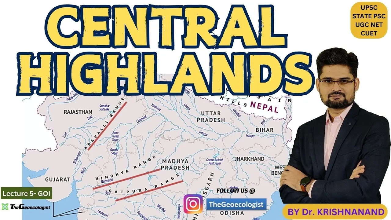
Table of Contents
- The Aravalli Range: Earth's Ancient Sentinel
- Geological Significance & Mineral Wealth
- Biodiversity Hotspots in an Arid Landscape
- Cultural Heritage: Forts, Faith & Folklore
- The Vindhyanchal Range: Sedimentary Chronicles & Sacred Rivers
- Sedimentary Origins & Diamond Legacy
- River Systems, Forests & Wildlife Corridors
- Sacred Geography & Prehistoric Art
- The Satpura Range: Gondwana Legacy & Biodiversity Stronghold
- Gondwana Geology & Dramatic Topography
- Tiger Reserves, Biosphere Reserves & Medicinal Flora
- Tribal Heritage, Rock Art & Living Traditions
- Ecological Importance of the Central Highlands of India
- Climate Regulation, Water Security & Carbon Sequestration
- Conservation Challenges & Policy Responses
- Exploring the Central Highlands of India: Research, Travel & Stewardship
The Central Highlands of India form a vast, ancient physiographic division that separates the Indo-Gangetic Plain from the Deccan Plateau, encompassing three major mountain systems—the Aravalli, Vindhyanchal, and Satpura ranges. Stretching across Rajasthan, Gujarat, Madhya Pradesh, Uttar Pradesh, Bihar, and Maharashtra, these highlands are not merely geological relics but living landscapes that regulate monsoon patterns, harbor exceptional biodiversity, and cradle millennia of human history. From the 1.5-billion-year-old folds of the Aravalli to the Gondwana-era sandstone of the Satpura, each range tells a distinct chapter of Earth’s deep time while sustaining millions of livelihoods today.
- The Central Highlands of India comprise three principal ranges: Aravalli (oldest), Vindhyanchal (sedimentary), and Satpura (Gondwana-era).
- These highlands act as a climatic barrier, shielding the fertile plains from desert expansion and feeding major rivers like the Narmada, Tapti, Chambal, and Son.
- They host UNESCO World Heritage Sites (Hill Forts of Rajasthan, Bhimbetka Rock Shelters), critical tiger reserves (Sariska, Ranthambore, Satpura, Bandhavgarh, Kanha), and rich tribal cultures.
- Conservation challenges include mining pressure, habitat fragmentation, and climate change, countered by Project Tiger, biosphere reserves, and community-led forest management.
The Aravalli Range: Earth’s Ancient Sentinel
Geological Significance & Mineral Wealth
The Aravalli Range, extending approximately 692 km from Champaner in Gujarat to Raisina Hill in Delhi, ranks among the oldest mountain systems on Earth, with roots in the Proterozoic Eon over 1.5 billion years ago. These once-towering peaks—now eroded to residual hills rarely exceeding 1,000 m—record multiple orogenic cycles, notably the Aravalli-Delhi Orogeny. The range’s mineral endowment is legendary: the Khetri Copper Belt (Rajasthan) has yielded copper since the Harappan period (c. 3000 BCE), while the Zawar mines pioneered zinc smelting as early as the 12th century CE. Makrana marble, quarried since Mughal times, clad the Taj Mahal. Erosion of these ancient rocks has deposited vast alluvial fans, creating the fertile plains of Punjab, Haryana, and western Uttar Pradesh that feed much of northern India. – a key consideration for Central Highlands of India.
Biodiversity Hotspots in an Arid Landscape
Despite receiving only 400–600 mm annual rainfall, the Aravalli supports surprising ecological diversity. The Central Highlands of India create microclimates where subtropical evergreen forests persist on Mount Abu (1,722 m), the range’s highest peak. Sariska Tiger Reserve (866 km²), declared a sanctuary in 1955 and a tiger reserve under Project Tiger in 1978, shelters Bengal tigers, leopards, striped hyenas, and the endangered Indian pangolin. The range’s southern spur harbors the Phulwari ki Nal and Sitamata wildlife sanctuaries, critical corridors for sloth bears and four-horned antelope (chousingha). Avian diversity exceeds 280 species, including the globally threatened Indian pitta and white-naped tit. These fragmented habitats face intense pressure from illegal mining—over 31% of the range’s forest cover was lost between 1975 and 2019, prompting the Supreme Court of India to ban mining in a 115.34 km² eco-sensitive zone in 2018.
Cultural Heritage: Forts, Faith & Folklore
The Aravalli’s strategic ridges nurtured Rajputana’s martial civilization. Six hill forts—Chittorgarh, Kumbhalgarh, Ranthambore, Gagron, Amber, and Jaisalmer—were inscribed as a UNESCO World Heritage Site in 2013 under the collective title “Hill Forts of Rajasthan.” Kumbhalgarh’s 36-km wall, built by Rana Kumbha in the 15th century, is the world’s second-longest continuous wall after the Great Wall of China. Pilgrimage centers abound: Pushkar Lake (mentioned in the Rigveda) hosts the annual Pushkar Camel Fair; Ajmer Sharif Dargah draws millions to the Sufi saint Moinuddin Chishti’s shrine; and the Dilwara Temples on Mount Abu showcase Māru-Gurjara marble architecture at its zenith (11th–13th centuries). The range also forms a natural barrier halting the Thar Desert’s eastward advance, protecting the Central Highlands of India‘s eastern watersheds and the Indo-Gangetic aquifer system.
The Vindhyanchal Range: Sedimentary Chronicles & Sacred Rivers
Sedimentary Origins & Diamond Legacy
The Vindhyanchal (or Vindhya) Range runs roughly 1,050 km east-west across Madhya Pradesh, Uttar Pradesh, and Bihar, forming the traditional boundary between northern and southern India. Unlike the metamorphic Aravalli, the Vindhyans comprise a 4–5 km thick sequence of Proterozoic sedimentary rocks (1.7–0.6 Ga) deposited in an intracratonic basin—the Vindhyan Supergroup. These horizontally bedded sandstones, shales, and limestones preserve exceptional fossil records, including the 1.6-billion-year-old red algae Rafatazmia, among the earliest known eukaryotes. The range’s kimberlite pipes at Majhgawan (Panna district) yielded India’s only industrial diamond mine (operational 1967–2020), producing over 1 million carats. Sandstone from Agra and Fatehpur Sikri built Mughal capitals, while the region’s limestone fuels major cement plants at Satna and Rewa. – a key consideration for Central Highlands of India.
River Systems, Forests & Wildlife Corridors
The Vindhyanchal acts as a critical water divide. The Narmada (India’s fifth-largest river, 1,312 km) originates at Amarkantak on the Maikal Hills (the Vindhya-Satpura junction), flowing westward through a rift valley to the Arabian Sea. The Son (784 km), a major Ganga tributary, rises nearby, draining eastward. These rivers sustain the Central Highlands of India‘s extensive tropical dry deciduous forests—dominated by teak (Tectona grandis), sal (Shorea robusta), and bamboo—which form a near-continuous corridor linking Bandhavgarh Tiger Reserve (1,536 km², declared 1968), Kanha Tiger Reserve (940 km², 1973), and Sanjay-Dubri Tiger Reserve (1,674 km², 2008). This landscape supports India’s highest tiger density (Bandhavgarh: 8 tigers/100 km²), along with hard-ground barasingha (swamp deer), Indian wild dog (dhole), and the critically endangered white-rumped vulture. The Ken-Betwa River Link Project, India’s first inter-basin water transfer, threatens to submerge 90 km² of Panna Tiger Reserve, sparking intense ecological debate.
Sacred Geography & Prehistoric Art
The Vindhyans are steeped in Hindu cosmology. The Narmada is revered as one of seven sacred rivers; its parikrama (circumambulation) is a 2,600-km pilgrimage undertaken by thousands annually. Ujjain (ancient Avantika), on the Shipra River (a Narmada tributary), hosts the Simhastha Kumbh Mela every 12 years and houses the Mahakaleshwar Jyotirlinga. The Bhimbetka Rock Shelters (UNESCO World Heritage Site, 2003) in Raisen district contain over 700 painted shelters spanning the Paleolithic to Medieval periods, with the oldest art dating to 30,000 years BP—depicting hunting scenes, communal dances, and early horse riders. These shelters provide the longest continuous record of human occupation in South Asia. The range also features in the Ramayana: the Vindhyas are said to have bowed to sage Agastya, allowing him passage to the south—a mythologized memory of ancient north-south cultural exchange. – a key consideration for Central Highlands of India.
The Satpura Range: Gondwana Legacy & Biodiversity Stronghold
Gondwana Geology & Dramatic Topography
The Satpura Range stretches 900 km from eastern Gujarat across Maharashtra and Madhya Pradesh to Chhattisgarh, its name deriving from Sanskrit sapta (seven) and pura (folds/hills). Geologically younger than its western counterparts, the Satpura’s core formed during the breakup of Gondwana (c. 150–100 Ma), with Deccan Traps basalt overlying Gondwana sedimentary sequences (Permian-Triassic coal-bearing formations). Dhupgarh (1,352 m) near Pachmarhi is the highest peak in the Central Highlands of India south of the Narmada. The range’s rugged topography—deep gorges (e.g., the 300-m-deep Dhoopgarh gorge), waterfalls (Bee Falls, Duchess Falls), and cave systems (Pandav Caves, Jatashankar)—results from differential erosion of basalt, sandstone, and shale. The Pachmarhi plateau (1,067 m), a UNESCO Biosphere Reserve since 2009, hosts a unique mosaic of moist deciduous forest, subtropical pine (Pinus roxburghii), and high-altitude grasslands.
Tiger Reserves, Biosphere Reserves & Medicinal Flora
The Satpura Tiger Reserve (2,133 km², established 1999) combines Satpura National Park, Bori Sanctuary, and Pachmarhi Sanctuary into a single conservation unit. Central Highlands of India harbors an estimated 50+ Bengal tigers, alongside Indian gaur (the world’s largest bovine), sloth bear, and the endemic Satpura leopard gecko (Cyrtodactylus satpuraensis, described 2021). The adjoining Melghat Tiger Reserve (2,768 km², Maharashtra) and Pench Tiger Reserve (1,179 km², straddling Madhya Pradesh-Maharashtra) create a 10,000 km² meta-population landscape. The Pachmarhi Biosphere Reserve alone documents 500+ medicinal plant species, including the endangered Rauvolfia serpentina (sarpagandha), Gloriosa superba (kalihari), and Chlorophytum borivilianum (safed musli). The Forest Department’s Joint Forest Management (JFM) committees, involving Gond and Korku communities, have regenerated 12,000 hectares of degraded forest since 2005 through assisted natural regeneration and NTFP (non-timber forest product) value chains.
Tribal Heritage, Rock Art & Living Traditions
The Satpura’s forests have sustained Adivasi communities for millennia. The Gond (India’s second-largest tribal group, ~14 million) and Korku practice shifting cultivation (jhum) transitioning to settled agroforestry. Their oral epics—like the Gond Gondi Punem—encode ecological knowledge of seasonal cycles, animal behavior, and plant uses. The Bhimbetka complex extends into the Satpura foothills, with rock art at Pachmarhi’s Mahadeo Hills depicting chariots, warriors, and ritual processions (c. 2000–1000 BCE). The annual Pachmarhi Utsav (since 2019) showcases tribal dance (Karma, Saila), craft (bamboo, bell metal), and cuisine (mahua flower liquor, kodo millet). However, the Forest Rights Act (2006) implementation remains patchy: only 38% of community forest resource claims have been recognized in Madhya Pradesh’s Satpura districts as of 2023, leaving many villages vulnerable to displacement. – a key consideration for Central Highlands of India.
Ecological Importance of the Central Highlands of India
Climate Regulation, Water Security & Carbon Sequestration
The Central Highlands of India function as a continental-scale climate regulator. The Aravalli intercepts the southwest monsoon’s Arabian Sea branch, forcing orographic rainfall that recharges the Luni, Sabarmati, and Banas river basins. The Vindhya-Satpura complex captures both Arabian Sea and Bay of Bengal monsoon currents, feeding the Narmada, Tapti, Mahanadi, and Godavari headwaters. Together, these ranges sustain surface water for 300+ million people and recharge aquifers across six states. Their forests—covering approximately 180,000 km² (Forest Survey of India, 2021)—sequester an estimated 2.1 Gt CO₂, with the Satpura-Maikal corridor alone storing 350 Mt C in above-ground biomass. Deforestation here directly weakens the Indian monsoon: a 2018 IIT Bombay study showed a 10–15% rainfall decline in central India correlated with 20% forest loss since 1980.
Conservation Challenges & Policy Responses
Despite their ecological centrality, the Central Highlands of India face accelerating threats. Mining leases cover 12% of the Aravalli’s forest area; the Vindhyan coalfields (Singrauli, Korba) produce 150 Mt/year, driving India’s thermal power but fragmenting tiger corridors. Linear infrastructure—NH-44 widening through Pench-Kanha, the Mumbai-Nagpur Expressway (Samruddhi Mahamarg) bisecting Melghat—creates mortality hotspots for large mammals. Climate models project a 1.5–2°C temperature rise and 5–10% monsoon intensification by 2050, elevating fire risk (2021 saw 345,000 fire alerts in central India, a 2.7× increase over 2001). Policy responses include the National Wildlife Action Plan (2017–31), which designates 52 landscape-level corridors; the Green India Mission targeting 5 Mha afforestation in central India; and the Compensatory Afforestation Fund Act (2016), which has accrued ₹54,000 crore for forest restoration. Community-led models—like the Mendha-Lekha village (Gadchiroli) governing 1,800 ha under CFR rights—demonstrate that secure tenure reduces deforestation by 40% compared to state-managed forests.
Exploring the Central Highlands of India: Research, Travel & Stewardship
For geologists, the Central Highlands of India offer a near-complete Proterozoic-to-Phanerozoic record accessible in road cuts and river gorges. The Aravalli’s Bhilwara Supergroup reveals early continental crust formation; the Vindhyan’s Semri Group preserves Mesoproterozoic microbialites; the Satpura’s Gondwana sequence documents Permian-Triassic floral turnover. Ecologists can study tiger meta-population dynamics across a 1,200-km corridor, or track phenological shifts in 500+ medicinal species under climate change. Cultural anthropologists find living traditions—from Bhil Gavri dance-drama (UNESCO Intangible Cultural Heritage nominee) to Korku seed festivals—that embody biocultural heritage. Responsible tourism is growing: Madhya Pradesh’s “Heart of India” campaign attracted 110 million domestic visitors in 2022, with tiger reserves generating ₹450 crore in gate revenue. Travelers can support conservation by choosing homestays in JFM villages, hiring local guides, and contributing to the Satpuda Foundation’s corridor securement fund. As the 2023 IPCC AR6 Synthesis Report emphasizes, protecting such intact, biodiverse, carbon-rich landscapes is among the most cost-effective climate mitigation strategies available—making the Central Highlands of India not just a national treasure but a global imperative.
Frequently Asked Questions
The three main mountain ranges of the Central Highlands of India are the Aravalli Range, the Vindhyanchal (Vindhya) Range, and the Satpura Range.
The Aravalli Range is the oldest, dating back over 1.5 billion years to the Proterozoic Era, making it one of the oldest mountain systems on Earth.
Major rivers originating in the Central Highlands of India include the Narmada, Tapti, Chambal, Son, Betwa, Ken, and Mahanadi, which drain both westward to the Arabian Sea and eastward to the Bay of Bengal.