Blog
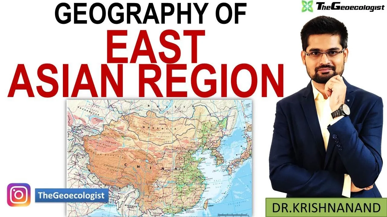
East Asian Geography: Physical Features, Climate & Human Dynamics

https://www.youtube.com/watch?v=your-video-
Table of Contents
- Physical Foundations: Tectonics, Mountains, and Plateaus
- The Pacific Ring of Fire and Seismic Activity
- Major Mountain Systems: The Himalayas, Kunlun, and Beyond
- The Tibetan Plateau: The "Roof of the World" and Climate Engine
- River Systems: Cradles of Civilization and Modern Industry
- The Yangtze River (Chang Jiang): China's Golden Artery
- The Yellow River (Huang He): The Sorrow and the Cradle
- The Mekong River: The Transboundary Lifeline
- Climate Zones and Biodiversity: From Desert to Jungle
- Arid and Semi-Arid Realms: The Gobi and Taklamakan
- Humid Subtropical and Tropical Zones: The Rice Bowl and Biodiversity Hotspots
- Human Geography: Culture, Settlement, and Economic Miracle
- Nomadic Traditions of the Eurasian Steppe
- River Valley Civilizations and the North-South Divide
- Maritime Cultures: The Japanese Archipelago and Philippine Islands
- Economic Powerhouse: The East Asian Miracle and Beyond
- Industrialization, Export-Led Growth, and the Flying Geese Model
- Innovation Hubs and the Middle-Income Trap Challenge
- Geopolitical Landscape: Resources, Sea Lanes, and Territorial Disputes
- The South China Sea: A Geographical Flashpoint
- The Korean Peninsula: Division, DMZ, and Nuclear Geography
- Environmental Challenges and Sustainability in the Anthropocene
- Climate Change Impacts: Sea Level Rise, Extreme Heat, and Glacial Melt
- Urbanization, Air Quality, and the Green Transition
- Conclusion: An Interconnected Geographical System
The study of East Asian geography reveals a region of extraordinary physical diversity and human complexity, stretching from the Siberian border in the north to the equatorial islands of the Philippines in the south. This vast realm encompasses China, Japan, the Koreas, Mongolia, and Taiwan, covering approximately 12 million square kilometers. Understanding East Asian geography is essential for grasping how mountain barriers, river systems, and monsoon climates have directed the flow of history, culture, and the modern global economy.
- Tectonic Foundation: The region sits on the convergent boundary of the Eurasian, Pacific, and Philippine Sea plates, creating the “Ring of Fire” with frequent seismic and volcanic activity.
- Hydrological Arteries: Major rivers like the Yangtze, Yellow, and Mekong originate on the Tibetan Plateau, supporting agriculture, transport, and hydroelectric power for hundreds of millions.
- Climatic Extremes: East Asian geography spans arid deserts (Gobi), humid subtropical zones, and tropical islands, dictating distinct agricultural and settlement patterns.
- Economic Powerhouse: The region hosts the world’s 2nd (China), 3rd (Japan), and 12th (South Korea) largest economies by nominal GDP, driven by export-oriented industrialization.
- Geopolitical Flashpoints: Territorial disputes in the South China Sea and the Korean Peninsula are deeply rooted in geographical realities of sea lanes, fisheries, and undersea resources.
Physical Foundations: Tectonics, Mountains, and Plateaus
The Pacific Ring of Fire and Seismic Activity
The defining characteristic of East Asian geography is its position along the Pacific Ring of Fire. The subduction of the Pacific Plate beneath the Eurasian Plate and the Philippine Sea Plate generates intense geological activity. Japan experiences approximately 1,500 earthquakes annually, while the 2011 Tohoku earthquake (magnitude 9.0) and the 2024 Noto Peninsula earthquake demonstrate the persistent hazard. Taiwan, situated on the collision zone between the Eurasian and Philippine Sea plates, faces similar risks. This tectonic volatility shapes not only the physical landscape but also urban planning, building codes, and disaster preparedness strategies across the region.
Major Mountain Systems: The Himalayas, Kunlun, and Beyond
Mountain ranges act as the skeletal structure of East Asian geography. The Himalayas, formed by the ongoing collision of the Indian Plate with Eurasia roughly 50 million years ago, form the southwestern barrier. They block cold, dry air from Central Asia and force the moisture-laden summer monsoon to drop precipitation across the subcontinent and southern China. North of the Himalayas, the Kunlun Mountains and the Tian Shan separate the Tibetan Plateau from the Tarim Basin and the Gobi Desert. In the east, the Qinling Mountains divide China into distinct northern and southern climatic, agricultural, and cultural zones. Japan’s Japanese Alps and the volcanic peaks of the Korean Peninsula (like Mount Paektu/Changbai) further fragment the landscape, creating isolated valleys that historically fostered distinct linguistic and cultural groups.
The Tibetan Plateau: The “Roof of the World” and Climate Engine
At an average elevation exceeding 4,500 meters, the Tibetan Plateau is the highest and largest plateau on Earth, covering 2.5 million square kilometers. Its role in East Asian geography cannot be overstated. The plateau acts as a massive heat source in summer, creating a low-pressure cell that draws the Southwest Monsoon deep into the continent. In winter, East Asian geography radiates heat, establishing a high-pressure cell that drives the cold, dry Northeast Monsoon. This thermal pump regulates the seasonal rhythm of life for billions. Furthermore, the plateau is the “Water Tower of Asia,” hosting the headwaters of the Yangtze, Yellow, Mekong, Salween, Brahmaputra, and Indus rivers. Glacial retreat on the plateau—accelerated by climate change—threatens long-term water security for downstream nations.
River Systems: Cradles of Civilization and Modern Industry
The Yangtze River (Chang Jiang): China’s Golden Artery
Flowing 6,300 km from the Tanggula Mountains on the Tibetan Plateau to the East China Sea at Shanghai, the Yangtze is the longest river in Asia and the third-longest globally. Its basin covers 1.8 million square kilometers, home to over 480 million people—roughly one-third of China’s population. The river is navigable for 2,800 km upstream, serving as a vital transport corridor connecting the interior (Chongqing, Wuhan) to the coast. The Three Gorges Dam, completed in 2012, is the world’s largest hydroelectric power station (22.5 GW capacity), symbolizing the harnessing of East Asian geography for industrial power. However, the dam has altered sediment flow, impacted fisheries (contributing to the functional extinction of the Baiji dolphin), and increased landslide risks along the reservoir banks.
The Yellow River (Huang He): The Sorrow and the Cradle
The Yellow River, stretching 5,464 km, is the birthplace of Chinese civilization. Its name derives from the massive load of yellow loess sediment East Asian geography carries from the Loess Plateau—up to 1.6 billion tons annually historically. This sediment raises the riverbed above the surrounding plains, necessitating massive levees and making the river prone to catastrophic course changes and floods, earning it the moniker “China’s Sorrow.” Since 1949, extensive dam construction (e.g., Sanmenxia, Xiaolangdi) and soil conservation on the Loess Plateau have mitigated flooding but reduced water flow to the Bohai Sea, causing periodic dry-ups in the lower reaches during the 1990s. The South-North Water Transfer Project, a mega-engineering feat of East Asian geography, now diverts Yangtze water northward to alleviate scarcity in the Yellow River basin and Beijing-Tianjin region.
The Mekong River: The Transboundary Lifeline
Known as the Lancang in China, the Mekong flows 4,909 km through six countries: China, Myanmar, Laos, Thailand, Cambodia, and Vietnam. Its basin supports 70 million people and the world’s largest inland fishery (2.6 million tons annually). The river’s seasonal flood pulse drives the Tonle Sap lake reversal in Cambodia, a unique hydrological phenomenon central to regional food security. However, the cascade of 11 mainstream dams built or planned in China (e.g., Nuozhadu, Xiaowan) and Laos (e.g., Xayaburi, Don Sahong) fundamentally alters the flood pulse, sediment transport, and fish migration. This makes the Mekong a critical case study in the geopolitics of East Asian geography, where upstream hydropower ambitions clash with downstream food security and ecological integrity.
Climate Zones and Biodiversity: From Desert to Jungle
Arid and Semi-Arid Realms: The Gobi and Taklamakan
The rain shadow of the Himalayas and the distance from oceanic moisture sources create vast deserts in the west and north. The Gobi Desert (1.3 million km²) spans southern Mongolia and northern China, characterized by extreme temperature swings (-40°C to 45°C) and gravel plains rather than sand dunes. The Taklamakan Desert (337,000 km²) in the Tarim Basin is China’s largest desert, historically a formidable barrier on the Silk Road. These arid zones support sparse populations engaged in nomadic pastoralism (sheep, goats, camels) and, increasingly, mineral extraction (copper, gold, rare earths in Mongolia’s Oyu Tolgoi and China’s Bayan Obo). Desertification, driven by overgrazing and climate change, expands the Gobi by ~3,600 km² annually, threatening Beijing with seasonal dust storms. – a key consideration for East Asian geography.
Humid Subtropical and Tropical Zones: The Rice Bowl and Biodiversity Hotspots
East of the Qinling-Huaihe line, East Asian geography transitions to humid subtropical (Cwa/Cfa Köppen) and tropical (Aw/Am) climates. The Sichuan Basin, Yangtze Delta, and Pearl River Delta enjoy long growing seasons (240–300 frost-free days) and abundant rainfall (1,000–2,000 mm), enabling double or triple-cropping of rice. This agricultural surplus historically supported dense populations and state formation. Southern China, Taiwan, and the Ryukyu Islands fall within the Indo-Burma and Japan biodiversity hotspots. The Hengduan Mountains in southwestern China are a global center of plant diversity. However, rapid urbanization—the Pearl River Delta is now the world’s largest urban area by population (~78 million)—fragments habitats and drives the illegal wildlife trade, a pressing conservation challenge.
Human Geography: Culture, Settlement, and Economic Miracle
Nomadic Traditions of the Eurasian Steppe
The Mongolian-Manchurian steppe, a temperate grassland belt, fostered a mobile pastoralist culture adapted to the harsh continental climate. The Mongol Empire (1206–1368), originating here, became history’s largest contiguous land empire, facilitated by the open geography of the steppe. Today, Mongolia remains one of the world’s least densely populated sovereign states (2.1 people/km²), with 30% of its 3.4 million people practicing semi-nomadic herding. However, mining (copper, coal) now dominates GDP, driving urbanization to Ulaanbaatar (home to 45% of the population) and creating severe winter air pollution from coal-fired ger district heating. – a key consideration for East Asian geography.
River Valley Civilizations and the North-South Divide
The North China Plain (Yellow River) and the Yangtze Delta formed the dual cores of Chinese civilization. The north, with its wheat/millet agriculture and need for coordinated flood control, encouraged centralized bureaucratic states. The south, with labor-intensive paddy rice cultivation, fostered dense, market-oriented village networks. This geographical duality persists: Mandarin dominates the north; Yue (Cantonese), Min, Hakka, and Wu dialects prevail in the rugged south. The Grand Canal (1,776 km), the world’s longest artificial waterway, constructed from the 5th century BCE to the 13th century CE, physically linked these two geographical hearts, enabling grain tribute transport and political integration. – a key consideration for East Asian geography.
Maritime Cultures: The Japanese Archipelago and Philippine Islands
Insular East Asian geography created distinct maritime civilizations. Japan’s four main islands (Honshu, Hokkaido, Kyushu, Shikoku) and 14,000+ smaller islands fostered a culture oriented toward the Pacific. The Kuroshio Current brings warm water northward, moderating coastal climates and supporting rich fisheries. Limited arable land (11% of Japan) and abundant rainfall drove intensive wet-rice farming and later, export-oriented manufacturing. The Philippines, an archipelago of 7,641 islands, developed diverse ethnolinguistic groups (170+ languages) shaped by sea lanes and trade with China, India, and the Islamic world. Its strategic location on the South China Sea and Philippine Sea makes East Asian geography a geopolitical pivot, hosting key U.S. military alliances under the 1951 Mutual Defense Treaty.
Economic Powerhouse: The East Asian Miracle and Beyond
Industrialization, Export-Led Growth, and the Flying Geese Model
The post-WWII economic transformation is a defining chapter in the human geography of the region. Japan’s “economic miracle” (1950s–1980s) was followed by the Four Asian Tigers (South Korea, Taiwan, Hong Kong, Singapore) and later China’s reform and opening up (1978). The “Flying Geese” model describes how labor-intensive industries migrated from Japan to the Tigers, then to Southeast Asia and coastal China, as wages rose. Coastal geography was crucial: Special Economic Zones (SEZs) like Shenzhen, Zhuhai, and Busan leveraged port access for export manufacturing. By 2023, East Asia accounted for ~27% of global GDP (PPP) and ~30% of world merchandise exports. The region’s manufacturing depth—from semiconductors (Taiwan’s TSMC produces 60% of global foundry revenue) to shipbuilding (South Korea’s HD Hyundai, China’s CSSC) and automotive (Japan’s Toyota, Hyundai-Kia)—is unmatched. – a key consideration for East Asian geography.
Innovation Hubs and the Middle-Income Trap Challenge
East Asian geography now hosts global innovation clusters: Tokyo-Yokohama (robotics, precision machinery), Seoul-Pangyo (semiconductors, biotech), Shanghai-Zhangjiang (AI, fintech), Shenzhen (hardware, drones, EVs), and Hsinchu (TSMC, IC design). R&D spending in the region exceeds 2.5% of GDP (South Korea 4.9%, Japan 3.3%, China 2.4% in 2022). However, demographic headwinds—Japan’s median age 49, South Korea’s fertility rate 0.72 (2023), China’s shrinking workforce—threaten long-term growth. The “middle-income trap” looms for China and Malaysia, requiring a shift from factor-driven to innovation-driven growth, a transition heavily dependent on education geography and urban talent attraction.
Geopolitical Landscape: Resources, Sea Lanes, and Territorial Disputes
The South China Sea: A Geographical Flashpoint
The South China Sea (3.5 million km²) epitomizes the intersection of East Asian geography and geopolitics. East Asian geography carries ~$3.4 trillion in annual trade (21% of global maritime trade), holds proven reserves of 11 billion barrels of oil and 190 trillion cubic feet of natural gas, and provides 12% of the global fish catch. China’s “Nine-Dash Line” claim overlaps with the Exclusive Economic Zones (EEZs) of Vietnam, the Philippines, Malaysia, Brunei, and Indonesia, based on UNCLOS (1982). China has militarized artificial islands in the Spratlys (Fiery Cross, Subi, Mischief Reefs) with runways, radar, and missile systems. The 2016 Permanent Court of Arbitration ruling (Philippines v. China) rejected the Nine-Dash Line’s legal basis, but enforcement remains elusive. Freedom of Navigation Operations (FONOPs) by the U.S. Navy and allies contest excessive claims, making the sea a potential trigger for great-power conflict.
The Korean Peninsula: Division, DMZ, and Nuclear Geography
The 250-km long, 4-km wide Demilitarized Zone (DMZ) along the 38th parallel is a stark geographical scar from the 1950–53 Korean War. Paradoxically, East Asian geography serves as a 907 km² de facto nature reserve, hosting endangered species like the Amur leopard and red-crowned crane. North Korea’s mountainous terrain (80% of land) limits arable land to 19%, contributing to chronic food insecurity, while its mineral wealth (magnetite, tungsten, rare earths) remains largely untapped due to sanctions. South Korea’s population (51 million) is concentrated in the Seoul Metropolitan Area (26 million, 50% of national population), just 40 km from the DMZ, creating extreme vulnerability to artillery and missile threats. The peninsula’s geography thus dictates a security dilemma where deterrence, diplomacy, and the prospect of reunification are all geographically constrained.
Environmental Challenges and Sustainability in the Anthropocene
Climate Change Impacts: Sea Level Rise, Extreme Heat, and Glacial Melt
East Asian geography is on the front lines of climate change. The IPCC AR6 projects sea-level rise of 0.4–0.8 meters by 2100, threatening mega-deltas (Yangtze, Pearl, Mekong, Chao Phraya) where hundreds of millions live. Shanghai, Tokyo, Osaka, and Bangkok face compounding flood risks from storm surges, land subsidence (up to 4 cm/yr in Jakarta/North Jakarta), and extreme rainfall. The 2021 Henan floods (617 mm in 3 days in Zhengzhou) and 2023 Typhoon Doksuri remnants flooding Beijing exemplify new extremes. On the Tibetan Plateau, glaciers have lost 15% of mass since 1970, with two-thirds projected to vanish by 2100 under high emissions, imperiling the “Asian Water Tower.” Heatwaves are intensifying: Shanghai recorded 40.9°C in 2023; the 2024 North China heatwave saw 50+ days above 35°C, stressing power grids and outdoor labor.
Urbanization, Air Quality, and the Green Transition
Urbanization rates exceed 65% in China, 81% in Japan, 81% in South Korea. This concentrates pollution but also enables efficiency. China’s “War on Pollution” (2014–present) cut PM2.5 by ~40% nationally via coal-to-gas switching, vehicle standards, and industrial relocation. However, ozone pollution is rising. The region leads the global energy transition: China installed 217 GW of solar and 76 GW of wind in 2023 alone (60% of global additions), dominates EV battery supply chains (CATL, BYD), and targets carbon neutrality by 2060. Japan and South Korea target 2050. Decarbonizing heavy industry (steel, cement) and managing the geography of renewable energy (western solar/wind to eastern load centers via UHVDC lines) are the next frontiers. – a key consideration for East Asian geography.
Conclusion: An Interconnected Geographical System
The East Asian geography we have explored is not a static backdrop but a dynamic, interconnected system where tectonics, climate, hydrology, and human agency continuously reshape one another. From the glacial headwaters of the Tibetan Plateau feeding the rice bowls of the deltas, to the maritime trade lanes linking factory floors to global markets, to the demographic and climate challenges redefining the region’s future—geography remains the master key. For policymakers, scholars, and global citizens, a deep, spatially grounded understanding of this realm is indispensable for navigating the 21st century. As the region pivots toward high-tech innovation, green energy, and a more contested geopolitical order, the physical and human landscapes described here will continue to dictate the realm of the possible.
For authoritative geographical data and regional analysis, consult the Wikipedia entry on East Asia and the World Bank East Asia & Pacific regional overview. Additional climatic and environmental datasets are available via the Encyclopædia Britannica East Asia portal.
Frequently Asked Questions
The major mountain ranges include the Himalayas, Kunlun Mountains, Tian Shan, Qinling Mountains, and the Japanese Alps. These ranges form climatic barriers, create the Tibetan Plateau, and influence monsoon patterns across the region.
The Yangtze, Yellow River (Huang He), Mekong (Lancang), Salween, Brahmaputra, and Indus rivers all originate on the Tibetan Plateau, making it the 'Water Tower of Asia' for billions downstream.
Coastal geography enabled export-oriented industrialization via port cities (SEZs). River systems support agriculture and transport. Mineral resources in Mongolia and China drive mining. However, limited arable land and aging populations pose structural challenges.