Blog
Himalayan Longitudinal Divisions: A Geological Study

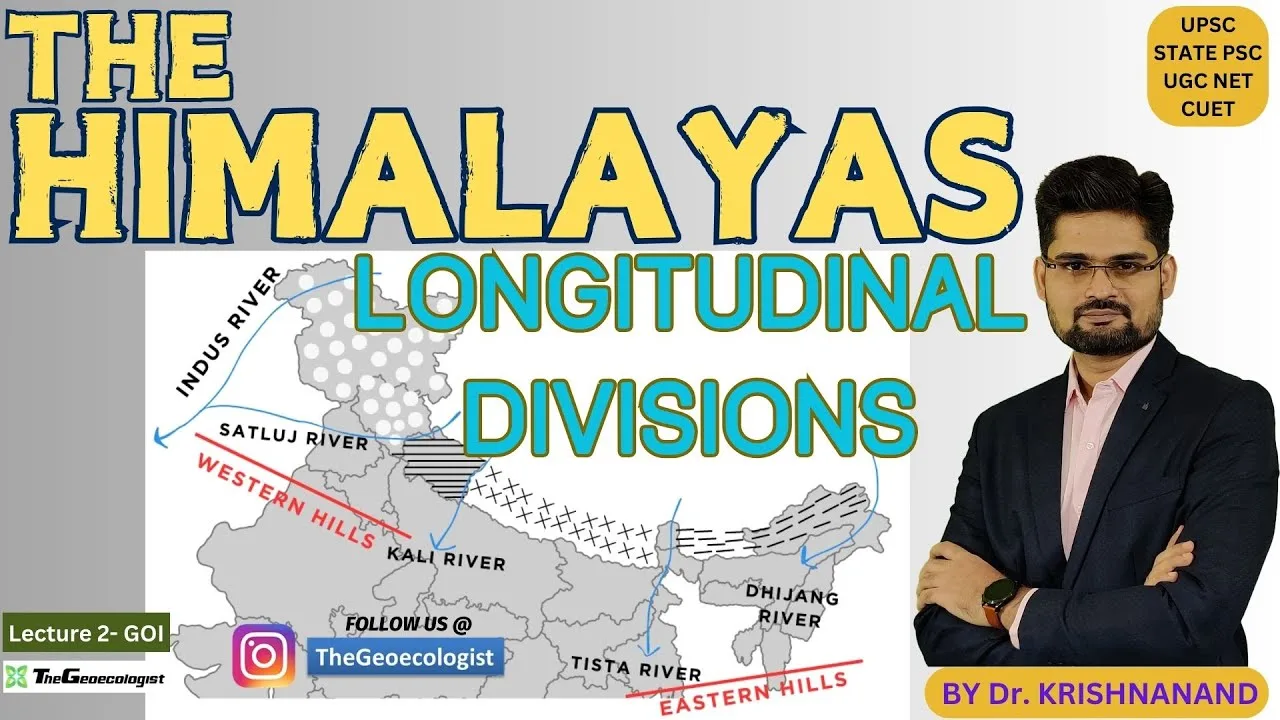
Table of Contents
- Understanding the Himalayan Longitudinal Divisions and Geological Evolution
- The Four Primary Himalayan Longitudinal Divisions
- The Architects of Himalayan Science: Burrard and Gansser
- Tectonic Processes and Regional Variability
- Why Studying the Himalayan Longitudinal Divisions Matters
- Conclusion: A Legacy of Geological Knowledge
Understanding the Himalayan Longitudinal Divisions and Geological Evolution
The Himalayan longitudinal divisions represent the intricate structural framework of Earth’s most imposing mountain system. Stretching across five sovereign nations—India, Nepal, Bhutan, China, and Pakistan—the Himalayas act as a massive climatic and geological barrier between the Indian subcontinent and the Tibetan Plateau. These mountains are not merely static monoliths; they are dynamic, evolving landscapes shaped by the relentless collision of the Indian and Eurasian tectonic plates. By studying the Himalayan longitudinal divisions, geoscientists can decode the complex history of continental drift and the ongoing processes that continue to shape our planet’s surface today.
- Structural Complexity: The range is categorized into distinct zones based on their geomorphology and tectonic characteristics.
- Pioneering Research: The classification relies on the foundational work of Sidney Gerald Burrard and August Gansser.
- Tectonic Activity: The divisions reflect different stages and intensities of the Indian-Eurasian plate collision.
- Global Impact: Understanding these zones is crucial for seismic risk assessment and climate modeling.
The Four Primary Himalayan Longitudinal Divisions
To understand the sheer scale of this mountain system, geographers divide the range into four primary sectors. Each sector, or Himalayan longitudinal division, exhibits unique topographical, geological, and ecological characteristics.
1. The Punjab Himalayas (Western Himalayas)
The westernmost sector, often referred to as the Punjab Himalayas, extends from the Indus River in Pakistan to the Sutlej River in India. This region encompasses critical areas such as Jammu & Kashmir and Himachal Pradesh. The topography is characterized by high-altitude valleys and steep slopes. One of the most significant geological features in this section is Nanga Parbat, standing at a staggering 8,126 meters. The geology of the Punjab Himalayas is defined by complex thrust faults and the presence of relatively young sedimentary rocks, reflecting the ongoing tectonic uplift in the western sector. The Kashmir Valley, famous for its iconic Dal Lake, serves as a vital geographical and cultural landmark within this division.
2. The Kumaon Himalayas
Spanning the region between the Sutlej and Kali Rivers, the Kumaon Himalayas cover much of Uttarakhand in India and parts of Nepal. This sector is a centerpiece for both spiritual pilgrimage and high-altitude trekking. Himalayan longitudinal divisions is home to some of the most breathtaking summits, including the legendary Nanda Devi (7,816 m). The Kumaon region is noted for its extensive glacial systems, such as the Gangotri Glacier, which is a primary source of the Ganges River. Geologically, the Lesser Himalayas in this zone are distinguished by significant metamorphic rock formations and deep, narrow valleys that demonstrate the intense pressure applied during the mountain-building process.
3. The Nepal Himalayas (Central Himalayas)
The central portion, known as the Nepal Himalayas, lies between the Kali and Tista Rivers. This is arguably the most famous section of the entire range, as Himalayan longitudinal divisions hosts the world’s highest peaks. Mount Everest (8,848 m) and Kanchenjunga (8,586 m) define the skyline of this division. The tectonic activity in this region is exceptionally intense, resulting in extreme vertical relief. A notable geographical feature is the Kali Gandaki Gorge, recognized as one of the deepest gorges in the world. The fertile Kathmandu Valley, tucked within these mountains, highlights the diverse ecological and geological landscape that the Nepal Himalayas provides. For more detailed geological context, one can refer to the geological profiles on Wikipedia.
4. The Assam Himalayas (Eastern Himalayas)
Moving further east, the Assam Himalayas stretch from the Tista River to the Brahmaputra River. This division encompasses parts of Arunachal Pradesh, Bhutan, and Sikkim. The terrain here is characterized by high rainfall and exceptionally dense forests, creating unique biodiversity hotspots. Notable peaks like Namcha Barwa (7,756 m) stand as sentinels of this eastern sector. The region is heavily influenced by the Brahmaputra Valley, and the geological structure is shaped by the oblique collision of the Indian Plate, which contributes to rapid erosion and frequent seismic activity in the Assam Himalayas.
The Architects of Himalayan Science: Burrard and Gansser
Our modern understanding of the Himalayan longitudinal divisions is built upon the monumental contributions of two key figures in geosciences: Sidney Gerald Burrard and August Gansser.
Sidney Gerald Burrard: The Cartographic Foundation
Sir Sidney Gerald Burrard was a distinguished British surveyor working with the Survey of India during the early 20th century. His seminal publication, The Geography and Geology of the Himalaya Mountains and Tibet (1907), provided the first systematic framework for categorizing the range. By synthesizing topographical surveys with geological observations, Burrard introduced the concept of longitudinal segmentation. His work allowed scientists to move away from viewing the Himalayas as a single entity and instead see them as a series of interconnected yet distinct geological provinces.
August Gansser: Tectonic Revolution
While Burrard provided the map, Swiss geologist August Gansser provided the engine. Conducting extensive fieldwork between the 1930s and 1950s, Gansser revolutionized the field with his landmark book, Geology of the Himalayas (1964). He moved beyond mere description to explain the *why* behind the mountains. Gansser was instrumental in detailing how the collision between the Indian and Eurasian plates created specific fault lines, such as the Main Central Thrust and the Indus-Tsangpo Suture Zone. His research bridged the gap between pure geography and dynamic tectonics, explaining how different Himalayan longitudinal divisions exhibit varying degrees of metamorphism based on their depth of crustal exposure.
Tectonic Processes and Regional Variability
The formation of the Himalayas is a process that began in the Eocene epoch and continues to this very day. This ongoing continental collision causes crustal shortening and massive uplift. However, the expression of this tectonic force is not uniform across the Himalayan longitudinal divisions.
In the Punjab Himalayas, the compression appears less intense, resulting in more pronounced folded sedimentary layers. In contrast, the Kumaon and Nepal regions show evidence of extreme pressure, characterized by high-grade gneisses and intense metamorphism. This occurs because these sections have been pushed higher and deeper into the crustal collision zone. Finally, the Assam Himalayas face a different challenge; the oblique angle of the Indian Plate’s collision leads to rapid erosion and a high frequency of seismic events, making this division particularly volatile.
Why Studying the Himalayan Longitudinal Divisions Matters
Understanding the Himalayan longitudinal divisions is not just an academic exercise; it has profound real-world implications. The geological data gathered from these zones is vital for several reasons:
- Disaster Preparedness: Knowing the fault lines within different divisions helps in predicting seismic risks and mitigating earthquake damage.
- Climate Science: The mountains dictate the monsoon patterns in South Asia; understanding their structure helps in modeling global climate shifts.
- Biodiversity Conservation: Each division hosts unique ecosystems that require specialized conservation strategies.
- Water Resource Management: The glaciers within these divisions are the lifelines for billions of people.
As the Earth’s crust continues to shift, the lessons learned from the work of Burrard and Gansser remain essential. The Himalayan longitudinal divisions serve as a living laboratory, reminding us of the immense power of tectonic forces and the beauty of a world in constant motion. To learn more about global geological wonders, you can explore resources on National Geographic.
Conclusion: A Legacy of Geological Knowledge
The Himalayan longitudinal divisions represent a masterclass in geological complexity. From the sedimentary folds of the west to the metamorphic giants of the center and the volatile slopes of the east, the range is a testament to the power of plate tectonics. Thanks to the legacies of Sidney Gerald Burrard and August Gansser, we possess the tools to categorize and understand this magnificent landscape. For students, geologists, and explorers alike, these divisions offer a roadmap to understanding the very forces that build our world.
Frequently Asked Questions
The four divisions are the Punjab Himalayas, Kumaon Himalayas, Nepal Himalayas, and Assam Himalayas.
Sir Sidney Gerald Burrard provided the initial longitudinal framework, while August Gansser provided the tectonic and geological insights.
It is the central section containing the world's highest peaks, such as Mount Everest, and is characterized by intense tectonic activity.