Blog
Himalayan Latitudinal Divisions: Complete Guide to Himadri, Himachal & Shiwaliks

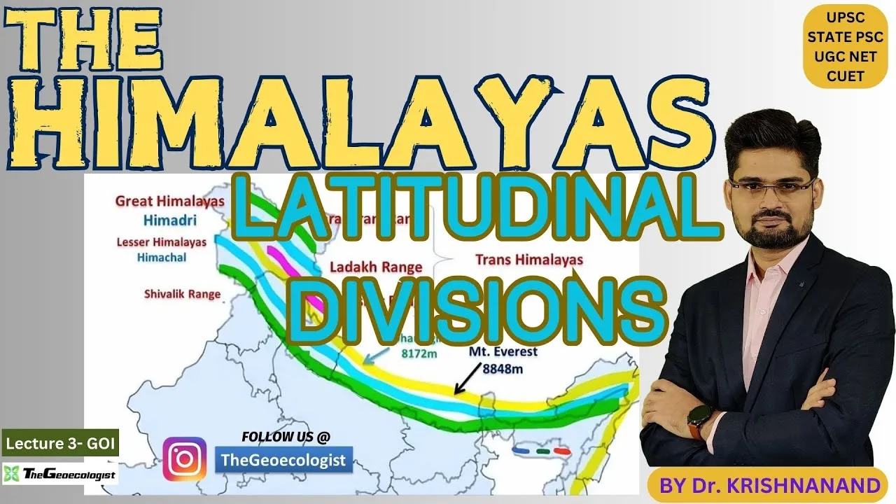
Table of Contents
- Understanding the Threefold Himalayan Latitudinal Divisions
- Greater Himalayas (Himadri): The Crystalline Core
- Lesser Himalayas (Himachal): The Folded Sedimentary Belt
- Outer Himalayas (Shiwaliks): The Active Foreland Basin
- Tectonic Framework: Major Thrust Faults Defining the Divisions
- Main Central Thrust (MCT)
- Main Boundary Thrust (MBT)
- Himalayan Frontal Thrust (HFT)
- Geological Evolution: 50 Million Years of Collision
- Ecological Significance: Biodiversity Across Latitudinal Zones
- Climatic Influence: The Monsoon Engine
- Disaster Vulnerability: Seismic and Geomorphic Hazards
- Significance for UPSC Examination
- Conclusion
The Himalayan latitudinal divisions represent one of the most fundamental classifications in physical geography, essential for understanding the structural architecture of the world’s youngest and highest mountain range. Stretching approximately 2,400 kilometers across five nations—India, Nepal, Bhutan, China (Tibet), and Pakistan—the Himalayas form a colossal arc that shapes the climate, ecology, and geology of the entire Indian subcontinent. The threefold latitudinal classification—Greater Himalayas (Himadri), Lesser Himalayas (Himachal), and Outer Himalayas (Shiwaliks)—was systematically developed by pioneering geologists Sidney Gerald Burrard and August Gansser during the early-to-mid 20th century, providing a framework that remains the cornerstone of Himalayan orogenic studies today.
- Three primary zones: The Himalayan latitudinal divisions comprise Himadri (Greater), Himachal (Lesser), and Shiwaliks (Outer) from north to south.
- Elevation range: From 900 meters in the Shiwaliks to 8,848.86 meters at Mount Everest in the Himadri.
- Tectonic origin: Formed by the ongoing Indian-Eurasian plate collision initiated ~50 million years ago.
- Key thrust faults: Main Central Thrust (MCT), Main Boundary Thrust (MBT), and Himalayan Frontal Thrust (HFT) separate the divisions.
- UPSC relevance: Core topic for Geography Optional, GS Paper I (Physical Geography), and Disaster Management.
Understanding the Threefold Himalayan Latitudinal Divisions
The concept of Himalayan latitudinal divisions organizes the orogen into parallel belts running roughly northwest-southeast, each with distinct geological age, lithology, structure, and topography. This classification reflects the progressive southward younging of deformation—a hallmark of the Himalayan fold-thrust belt. Burrard’s trigonometric surveys (1900s-1930s) and Gansser’s geological mapping (1930s-1960s) established that each division represents a distinct tectonostratigraphic package separated by major crustal-scale thrust faults.
Greater Himalayas (Himadri): The Crystalline Core
The northernmost and highest of the Himalayan latitudinal divisions, the Himadri (Sanskrit: “abode of snow”), forms a continuous 2,400-km barrier with average elevations exceeding 6,000 meters. This division hosts Earth’s highest peaks: Mount Everest (8,848.86 m), K2 (8,611 m), Kangchenjunga (8,586 m), Lhotse (8,516 m), Makalu (8,485 m), Cho Oyu (8,188 m), Dhaulagiri (8,167 m), Manaslu (8,163 m), Nanga Parbat (8,126 m), and Annapurna I (8,091 m). The Himadri is composed predominantly of high-grade metamorphic rocks—gneisses, schists, migmatites, and granitic intrusions—collectively termed the Greater Himalayan Sequence (GHS). These rocks record peak metamorphic conditions of 650-750°C and 8-10 kbar, indicating burial depths of 25-30 km during the Eocene-Oligocene.
The Himadri contains the largest concentration of glaciers outside polar regions—approximately 15,000 glaciers covering ~33,000 km². Major glaciers include Gangotri (30 km long, source of Bhagirathi), Siachen (76 km, world’s second-longest non-polar glacier), Zemu, Milam, and Pindari. These glaciers feed perennial river systems—Indus, Ganga, Brahmaputra—supporting over 600 million people downstream. The division acts as a climatic barrier, forcing the southwest monsoon to precipitate heavily on southern slopes while creating rain-shadow deserts (Ladakh, Spiti) to the north. Sidney Burrard’s precise triangulation established the first accurate elevations of major peaks, while August Gansser’s 1964 work “Geology of the Himalayas” documented the metamorphic core complexes and the South Tibetan Detachment System (STDS), a series of low-angle normal faults capping the GHS. – a key consideration for Himalayan latitudinal divisions.
Lesser Himalayas (Himachal): The Folded Sedimentary Belt
South of the Main Central Thrust (MCT) lies the Lesser Himalayas or Himachal (“abode of snow” in a lesser sense), the middle of the three Himalayan latitudinal divisions. This 60-80 km wide belt ranges from 3,700 to 4,500 meters in elevation and comprises intensely folded and thrust-faulted Proterozoic to Paleozoic sedimentary sequences—shales, limestones, quartzites, slates, and phyllites of the Lesser Himalayan Sequence (LHS). The LHS represents the northern passive margin of the Indian plate, deformed during the Himalayan orogeny. Key structural features include the Krol Belt, Deoban Group, and the famous “klippen” (erosional remnants of thrust sheets) such as the Simla and Almora klippen.
This division hosts iconic longitudinal valleys—Kashmir Valley (15,520 km²), Kullu Valley, Kangra Valley, and Doon Valley—formed along synclinal axes or fault zones. These valleys support dense populations, horticulture (apple, stone fruits), and tourism. The Lesser Himalayas are a biodiversity hotspot: temperate broadleaf forests (oak, rhododendron, maple) between 1,500-3,000 m, and coniferous forests (chir pine, blue pine, deodar, fir, spruce) higher up. The region records 3,500+ flowering plant species, 500+ bird species, and mammals like Himalayan black bear, leopard, and musk deer. Burrard identified the MCT as the fundamental boundary separating the crystalline Himadri from the sedimentary Himachal, while Gansser elucidated the duplex structures and out-of-sequence thrusting that characterize this zone. The Lesser Himalayas also host major hydropower projects (Bhakra-Nangal, Tehri, Nathpa Jhakri) exploiting the steep gradients of rivers like Sutlej, Beas, and Yamuna. – a key consideration for Himalayan latitudinal divisions.
Outer Himalayas (Shiwaliks): The Active Foreland Basin
The southernmost of the Himalayan latitudinal divisions, the Shiwaliks (also Sub-Himalaya or Churia Hills), form a 10-50 km wide belt of low hills (900-1,500 m) composed of unconsolidated to semi-consolidated Neogene-Quaternary molasse sediments—sandstones, siltstones, mudstones, and conglomerates derived from the erosion of the rising Himalayas. These sediments, exceeding 5-7 km thickness in places, were deposited in the Himalayan foreland basin between ~15 Ma and present. The Shiwaliks are subdivided into Lower (Middle Miocene), Middle (Late Miocene-Pliocene), and Upper (Pleistocene) subgroups, each reflecting progressive coarsening and proximal alluvial fan deposition as the orogen advanced southward.
The Shiwaliks are tectonically the most active division, bounded southward by the Himalayan Frontal Thrust (HFT), which accommodates ~15-20 mm/yr of the total ~45-50 mm/yr India-Eurasia convergence. This makes the zone highly prone to earthquakes (e.g., 1905 Kangra M7.8, 1934 Bihar-Nepal M8.1, 2015 Gorkha M7.8), landslides, and flash floods. The famous “Duns” (longitudinal valleys like Dehra Dun, Kotli Dun, Patli Dun) lie between the Shiwaliks and Lesser Himalayas, filled with lacustrine and fluvial sediments. The Shiwaliks host the Terai-Duar savanna and grasslands—a UNESCO-recognized ecoregion supporting tiger, rhinoceros, elephant, and swamp deer. Gansser’s foreland basin analysis established the Shiwaliks as a classic example of a retroarc foreland system, while Burrard’s drainage studies highlighted their role in sediment routing from the high Himalaya to the Indo-Gangetic plains. The Himalayas thus represent a complete source-to-sink sedimentary system.
Tectonic Framework: Major Thrust Faults Defining the Divisions
The boundaries between Himalayan latitudinal divisions are not arbitrary lines but major crustal-scale thrust faults that accommodate crustal shortening. Understanding these structures is critical for both geological comprehension and seismic hazard assessment.
Main Central Thrust (MCT)
The MCT separates the Greater Himalayas (Himadri) from the Lesser Himalayas (Himachal). First mapped by Heim and Gansser in 1939, this north-dipping thrust places high-grade metamorphic rocks of the GHS over low-grade LHS along a 2,400-km trace. The MCT zone is 1-5 km wide, characterized by intense ductile shearing, mylonites, and inverted metamorphic gradients (higher grade over lower grade). Himalayan latitudinal divisions was active during the Early-Middle Miocene (22-15 Ma) and represents the main crustal ramp that exhumed the Greater Himalayan crystalline core. Modern GPS studies show the MCT is currently locked, accumulating elastic strain for future large earthquakes.
Main Boundary Thrust (MBT)
The MBT marks the boundary between the Lesser Himalayas (Himachal) and the Outer Himalayas (Shiwaliks). Himalayan latitudinal divisions emplaces Proterozoic-Paleozoic LHS over Neogene Shiwalik molasse. The MBT is a steep north-dipping fault active since the Late Miocene (~10 Ma), with a total displacement of 30-50 km. It forms prominent topographic escarpments and controls the location of Dun valleys. The MBT zone is seismically active, with numerous M5-6 earthquakes historically recorded along its trace.
Himalayan Frontal Thrust (HFT)
The HFT (also called the Main Frontal Thrust) is the southernmost and youngest structure, separating the Shiwaliks from the Indo-Gangetic alluvial plains. Himalayan latitudinal divisions is a blind thrust in many sectors, propagating southward at ~15-20 mm/yr. The HFT accommodates nearly half the total convergence and is the primary source of great Himalayan earthquakes (M8+). Paleoseismic trenching across the HFT reveals evidence of 4-5 great earthquakes in the past 2,000 years, with recurrence intervals of 400-600 years. The 1505, 1803, 1934, 1950, and 2015 events likely ruptured segments of the HFT.
Geological Evolution: 50 Million Years of Collision

The story of the Himalayan latitudinal divisions begins ~50 Ma when the Indian plate, moving northward at ~15-20 cm/yr, collided with the Eurasian plate. The Neo-Tethys Ocean closed, and the Indian passive margin sediments were scraped off, folded, and thrust southward onto the Indian craton. The collision progressed in stages: (1) 50-40 Ma: initial contact, ophiolite obduction (Indus Suture Zone); (2) 40-25 Ma: crustal thickening, Barrovian metamorphism, leucogranite generation; (3) 25-15 Ma: MCT activation, exhumation of Greater Himalayan Sequence; (4) 15-10 Ma: MBT activation, Lesser Himalayan duplexing; (5) 10 Ma-present: HFT propagation, Shiwalik deposition and deformation. This progressive southward younging of deformation created the three latitudinal divisions we observe today. The geology of the Himalayas thus records a complete Wilson cycle from passive margin to collisional orogen.
Ecological Significance: Biodiversity Across Latitudinal Zones
Each of the Himalayan latitudinal divisions harbors distinct ecosystems shaped by elevation, aspect, precipitation, and geological substrate. The Himadri hosts alpine meadows, cold deserts (Trans-Himalaya), and nival zones with specialized flora (Saussurea, Rhodiola) and fauna (snow leopard, Himalayan wolf, blue sheep). The Himachal supports temperate broadleaf and coniferous forests—globally significant for oak (Quercus spp.) and rhododendron diversity (30+ species). The Shiwaliks and adjacent Terai harbor subtropical forests (sal, Shorea robusta) and grasslands, forming critical tiger and rhino habitat. The Himalayas contain 4 global biodiversity hotspots (Himalaya, Indo-Burma, Mountains of Southwest China, Western Ghats-Sri Lanka) and 10% of Earth’s flowering plants. Vertical zonation compresses tropical to arctic ecosystems within 100-150 km horizontal distance—a unique feature of these latitudinal divisions.
Climatic Influence: The Monsoon Engine
The Himalayan latitudinal divisions collectively function as the primary orographic barrier governing the Indian Summer Monsoon. The Himadri intercepts moisture-laden southwest winds (June-September), forcing ascent, condensation, and precipitation on southern slopes (2,000-5,000 mm/yr in places like Cherrapunji). This creates one of Earth’s steepest precipitation gradients—from >4,000 mm on windward slopes to <100 mm in the Trans-Himalayan rain shadow (Ladakh, Spiti) over <100 km. The Lesser Himalayas receive orographic rainfall supporting dense forests and agriculture. The Shiwaliks experience intense monsoonal runoff, driving high sediment flux (1-2 billion tons/yr) to the Indo-Gangetic plains and Bay of Bengal. Winter westerlies bring snow to higher divisions, sustaining glaciers. Climate change is altering this system: glaciers lost 0.3-0.5 m water equivalent/yr since 2000, monsoon patterns are shifting, and extreme precipitation events are increasing.
Disaster Vulnerability: Seismic and Geomorphic Hazards
The active tectonics defining the Himalayan latitudinal divisions create a multi-hazard landscape. The entire Himalayan arc falls in Seismic Zones IV and V (highest risk) of India’s seismic zoning map. The 2,400-km HFT is capable of generating M8+ earthquakes; seismic gaps (Central Himalaya, Assam Gap) have not ruptured in 300-500 years, implying accumulated strain. Landslides are pervasive: the 1998 Malpa, 2013 Kedarnath, 2014 Malin, and 2021 Chamoli disasters killed thousands. Glacial Lake Outburst Floods (GLOFs) threaten downstream communities—South Lhonak Lake (Sikkim) burst in October 2023, causing 80+ deaths. The Shiwaliks’ unconsolidated sediments amplify ground shaking and liquefaction risk. Understanding the structural geology of each latitudinal division is essential for hazard zonation, early warning systems, and resilient infrastructure planning.
Significance for UPSC Examination
Mastery of the Himalayan latitudinal divisions is indispensable for UPSC aspirants across multiple papers: GS Paper I (Physical Geography—geomorphology, climatology, biogeography; Disaster Management—earthquakes, landslides, GLOFs), Geography Optional (Paper I: Geomorphology, Climatology; Paper II: Regional Planning, Resources, Environmental Geography), and Essay (topics on Himalayan ecology, climate change, disaster resilience, federalism and water sharing). Questions frequently test: (1) distinction between the three divisions—elevation, geology, vegetation; (2) thrust faults—MCT, MBT, HFT characteristics and seismic role; (3) river systems and glaciers; (4) biodiversity and conservation; (5) climate change impacts; (6) disaster case studies. The Burrard-Gansser classification provides the standard framework expected in model answers. Aspirants should prepare annotated maps showing divisions, thrusts, peaks, glaciers, rivers, and seismic zones.
Conclusion
The Himalayan latitudinal divisions—Himadri, Himachal, and Shiwaliks—are not merely geographic labels but tectonostratigraphic provinces that record the ongoing collision between India and Eurasia. From the crystalline peaks of the Greater Himalayas to the actively deforming foreland basin of the Shiwaliks, each division tells a chapter of Earth’s most dramatic mountain-building event. For UPSC aspirants, geologists, geographers, and policymakers, this threefold classification remains the essential lens through which to view Himalayan geodynamics, ecology, climate, and hazard. As the Himalayas continue to rise ~5 mm/yr and the Indian plate advances ~45 mm/yr, these divisions will continue to evolve, demanding sustained scientific observation and informed governance to safeguard the millions who depend on this “Water Tower of Asia.”
Frequently Asked Questions
The three latitudinal divisions of the Himalayas are the Greater Himalayas (Himadri), the Lesser Himalayas (Himachal), and the Outer Himalayas (Shiwaliks), classified by geologists Sidney Burrard and August Gansser based on elevation, geology, and tectonic structure.
The Main Central Thrust (MCT) is a major north-dipping thrust fault separating the Greater Himalayas (Himadri) from the Lesser Himalayas (Himachal). It places high-grade metamorphic rocks over low-grade sedimentary rocks, was active 22-15 Ma, and is currently locked, accumulating strain for future large earthquakes.
The Shiwaliks consist of unconsolidated Neogene-Quaternary sediments (sandstone, mudstone, conglomerate) and are bounded by the active Himalayan Frontal Thrust (HFT), which accommodates ~15-20 mm/yr of convergence. This combination of weak lithology and active tectonics makes them highly susceptible to landslides, liquefaction, and seismic shaking.