Blog
World Population-Distribution, Density and Growth–Chapter 2-Class 12 -NCERT

World Population-Distribution, Density and Growth–Chapter 2-Class 12 -NCERT
Understanding World Population: Distribution, Density, and Growth
(Based on NCERT Class 12 Geography & TheGeoecologist’s Comprehensive Guide)
Population geography, a key focus of Class 12 NCERT’s Fundamentals of Human Geography (Chapter 2), unravels the dynamics of how humans occupy space on Earth. This article simplifies concepts like population distribution, density, and growth, aligning with the NCERT syllabus while incorporating insights from TheGeoecologist’s bilingual (Hindi-English) video lectures, tailored for CBSE students and competitive exam aspirants.
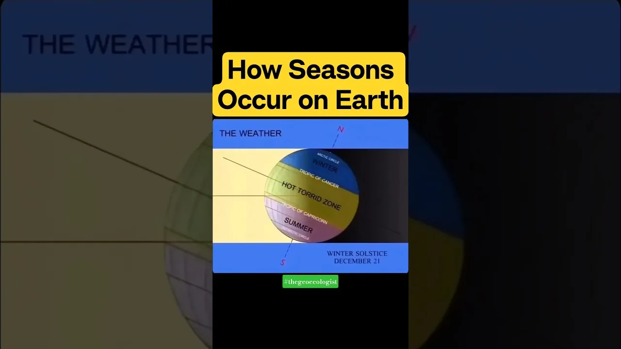
1. Population Distribution: Where Do People Live?
Population distribution refers to the spatial arrangement of humans across the globe. Notice that 90% of the world’s population lives on just 10% of the land, clustered in regions with favorable geographic and socio-economic conditions:
- Geographical Factors:
- Climate: Temperate zones (e.g., Europe, East Asia) are more populated than extreme deserts or polar regions.
- Water Availability: River valleys (Ganga, Nile) have supported civilizations for millennia.
- Terrain: Flat plains (Indo-Gangetic Plains) are preferred over mountains (the Himalayas).
- Human Factors:
- Economic opportunities in urban-industrial hubs (Mumbai, Tokyo).
- Political stability and social infrastructure.
Highly Populated Regions: South Asia, East Asia, Europe, Northeastern USA.
Sparsely Populated Regions: Sahara Desert, Amazon Basin, Polar areas.
2. Population Density: Intensity of Settlement
Population density measures the number of people per unit area (persons/km²). For instance:
- High Density: Bangladesh (1,300/km²), Singapore (8,000/km²) – driven by fertile land, urbanization, and resources.
- Low Density: Mongolia (2/km²), Australia (3/km²) – due to arid climates and limited arable land.
Factors influencing density mirror those affecting distribution but highlight resource availability and technological advancements (e.g., Japan supports high density despite limited land through efficient farming).
3. Population Growth: Trends and Drivers
Population growth is shaped by birth rates, death rates, and migration:
- Natural Growth = Crude Birth Rate (CBR) – Crude Death Rate (CDR).
- Demographic Transition Model (DTM): Explains shifts from high birth/death rates (Stage 1) to low birth/death rates (Stage 4). Developing nations often lag in later stages.
- Migration: Impacts regional growth (e.g., urbanization in India, Gulf migration).
Case Studies:
- China’s One-Child Policy (1979–2016): Slowed growth but caused gender imbalance.
- Kerala’s Success: High literacy and healthcare reduced fertility rates without coercion.
Challenges & Sustainable Development
Rapid population growth strains resources, leading to:
- Overcrowding, unemployment, and environmental degradation.
- Solutions: Empowerment through education (SDG 4), healthcare access (SDG 3), and balanced resource management.
Why Study This Chapter?
- CBSE Class 12: Core for Geography exams, emphasizing map-based questions.
- CUET, UPSC, UGC NET: Frequently tested on population theories, DTM, and policies.
- Real-World Relevance: Informs policies on urban planning, climate resilience, and equitable growth.
Enhance Your Preparation!
For deeper insights, watch TheGeoecologist’s bilingual video lecture, blending Hindi-English explanations for clarity. Complement your NCERT studies with structured courses on thegeoecologist.com, designed for school exams and competitive success.
Follow on Instagram: @thegeoecologist
Email queries: krishna.geography@gmail.com
class12 #ncertgeography #humangeography #upsc #cuet #competitiveexams
Master population geography with TheGeoecologist—where learning transcends language barriers! 🌍📚
To Download E-Books & Study Material Visit The Shop Page