Blog
Sub-Saharan Africa geography: Comprehensive Guide for UPSC

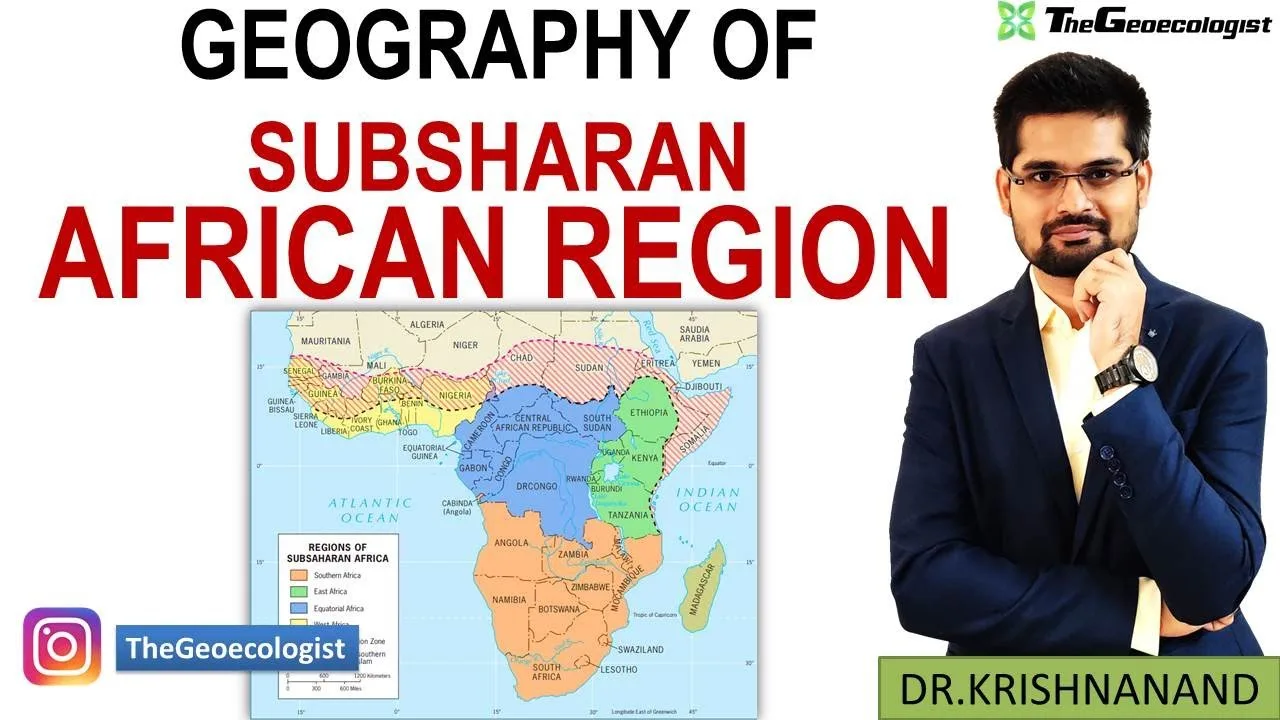
Table of Contents
- What Defines Sub-Saharan Africa Geography?
- Countries and Sub-regions
- Physical Boundaries and the Sahara Divide
- Physical Geography: Landforms Shaping Sub-Saharan Africa Geography
- The Great Rift Valley: Tectonic Backbone
- Major River Systems: Lifelines of the Region
- Climate Zones and Biodiversity Hotspots
- Human and Economic Dimensions of Sub-Saharan Africa Geography
- Population Distribution Patterns
- Agriculture, Mining, and Resource Wealth
- Rapid Urbanization and Megacity Growth
- Environmental Challenges and Socioeconomic Vulnerabilities
- Desertification in the Sahel
- Deforestation in the Congo Basin
- Water Scarcity and Health Burdens
- Geopolitical Significance and Regional Integration
- Strategic Chokepoints: Horn of Africa and Swahili Coast
- Global Partnerships: China, Europe, and the African Union
- Case Study: South Africa – A Microcosm of Sub-Saharan Africa Geography
- Physical Diversity: Drakensberg, Cape Floristic Region, Karoo
- Economic Powerhouse: Mining, Manufacturing, Tourism
- Post-Apartheid Social Dynamics
- Exam-Centric Preparation Tips for UPSC
- Map-Based Questions and Interlinkages
- Case Studies: Grand Renaissance Dam, Geothermal Energy
- Sustainable Development Goals and Climate Action
- Why Mastering Sub-Saharan Africa Geography Matters for Competitive Exams
Understanding Sub-Saharan Africa geography is essential for aspirants preparing for competitive examinations like the UPSC, particularly for Geography Optional. This region, lying south of the Sahara Desert, encompasses 46 countries and presents immense geographical diversity, cultural richness, and strategic importance. In this comprehensive guide, we break down the complexities of the region—covering physical landforms, climate zones, human and economic activities, environmental challenges, and geopolitical significance—tailored for exam preparation.
- Sub-Saharan Africa geography covers 46 countries south of the Sahara, divided into West, East, Central, and Southern Africa.
- The Great Rift Valley, major river systems (Congo, Niger, Zambezi), and diverse climate zones (rainforest, savanna, Sahel) define its physical landscape.
- Population concentrates in fertile highlands and coastal areas; economy relies on agriculture, mining (gold, diamonds, coltan), and oil.
- Key challenges: desertification in the Sahel, deforestation in the Congo Basin, water scarcity, disease burden, and political instability.
- Geopolitically vital: Horn of Africa shipping lanes, China’s Belt and Road investments, African Union and ECOWAS integration efforts.
- Exam focus: map-based questions, interlinkages with current affairs, case studies (Grand Renaissance Dam, geothermal energy), and SDG relevance.
What Defines Sub-Saharan Africa Geography?
Countries and Sub-regions
Sub-Saharan Africa geography is politically and culturally distinct from North Africa. The region includes four major sub-regions: West Africa (Nigeria, Ghana, Senegal), East Africa (Kenya, Ethiopia, Tanzania), Central Africa (Democratic Republic of the Congo, Cameroon), and Southern Africa (South Africa, Zimbabwe, Botswana). Together they account for over 1.1 billion people (World Bank, 2023) and a land area of approximately 24 million km². For a detailed list of countries and boundaries, refer to the Wikipedia entry on Sub-Saharan Africa.
Physical Boundaries and the Sahara Divide
The Sahara Desert acts as a massive climatic and cultural barrier. South of it, the Sahel—a semi-arid transitional belt—stretches from Senegal to Eritrea. This zone is critical in Sub-Saharan Africa geography because it marks the shift from desert to savanna and is ground zero for desertification debates. The region’s southern limit is the Cape of Good Hope, while the Indian Ocean and Atlantic Ocean flank the east and west coasts respectively.
Physical Geography: Landforms Shaping Sub-Saharan Africa Geography
The Great Rift Valley: Tectonic Backbone
The Great Rift Valley is the most dramatic landform in Sub-Saharan Africa geography. Extending over 6,000 km from Mozambique to the Red Sea, it is a divergent plate boundary where the African Plate is splitting into the Nubian and Somali plates. This tectonic activity creates volcanoes (e.g., Mount Kilimanjaro, Mount Kenya), deep lakes (Lake Tanganyika, Lake Malawi), and highlands (Ethiopian Highlands). The valley’s lakes hold 25% of the planet’s unfrozen freshwater. Learn more about its formation at the Great Rift Valley Wikipedia page.
Major River Systems: Lifelines of the Region
Three river basins dominate Sub-Saharan Africa geography:
- Congo River Basin: Second-largest rainforest globally (after Amazon), discharging 41,000 m³/s. It drains 3.7 million km² across nine countries. The Congo River is navigable for long stretches, facilitating trade.
- Niger River: West Africa’s lifeline, 4,180 km long, with an unusual inland delta in Mali supporting agriculture and fisheries.
- Zambezi River: Flows 2,574 km through six countries, featuring Victoria Falls (108 m drop) and major hydroelectric dams (Kariba, Cahora Bassa).
Climate Zones and Biodiversity Hotspots
Sub-Saharan Africa geography exhibits a latitudinal climate sequence:
- Tropical Rainforest (0°–5° N/S): Congo Basin, 2,000+ mm annual rainfall, high endemism (okapi, forest elephant).
- Savanna (5°–15° N/S): Serengeti, Miombo woodlands; distinct wet/dry seasons; supports “Big Five” wildlife tourism.
- Sahel (15°–18° N): 200–600 mm rainfall; prone to drought; desertification advancing southward at ~0.6 km/yr (UNCCD).
- Mediterranean (Cape region): Winter rainfall, unique fynbos biome (Cape Floristic Region, a UNESCO World Heritage Site).
Human and Economic Dimensions of Sub-Saharan Africa Geography
Population Distribution Patterns
Population density in Sub-Saharan Africa geography correlates strongly with water and soil fertility. The Ethiopian Highlands (100+ persons/km²), Nigerian coastal belt, and Lake Victoria basin are densely settled. Conversely, the Namib and Kalahari deserts, and the Congo rainforest interior, have densities below 5 persons/km². The region’s population is projected to double by 2050 (UN DESA), intensifying pressure on resources.
Agriculture, Mining, and Resource Wealth
Agriculture employs ~55% of the workforce (World Bank). Key cash crops: cocoa (Côte d’Ivoire, Ghana—70% global supply), coffee (Ethiopia, Uganda), cotton (Burkina Faso, Mali). Mining is a revenue pillar: South Africa holds 90% of global platinum reserves; Botswana leads in gem diamonds; DRC produces 70% of world’s cobalt and 60% of coltan (critical for electronics). Oil: Nigeria (1.5 mb/d) and Angola (1.1 mb/d) are top exporters.
Rapid Urbanization and Megacity Growth
Urbanization rate exceeds 4% annually. Lagos (21 million), Kinshasa (17 million), and Cairo (though North Africa) are megacities. Nairobi, Addis Ababa, and Luanda are fast-growing. Infrastructure deficits—housing, transport, sanitation—create sprawling informal settlements (e.g., Kibera, Nairobi). This urban transition is a core theme in Sub-Saharan Africa geography for exam questions on demographic dividend vs. urban crisis.
Environmental Challenges and Socioeconomic Vulnerabilities
Desertification in the Sahel
The Sahel loses ~12 million hectares annually to desertification (UNCCD). Drivers: overgrazing, fuelwood extraction, climate change (rainfall down 20–30% since 1960s). The Great Green Wall initiative aims to restore 100 million hectares by 2030 across 11 countries—a key case study for sustainable development answers.
Deforestation in the Congo Basin
The Congo Basin lost 16.5 million hectares (2000–2020, Global Forest Watch). Logging, mining, and shifting agriculture are primary causes. This threatens carbon sequestration (basin stores 60 Gt CO₂) and indigenous livelihoods (e.g., Mbuti pygmies). REDD+ projects and transboundary parks (Sangha Tri-National) are mitigation efforts.
Water Scarcity and Health Burdens
Uneven rainfall and poor management cause chronic water stress. Lake Chad shrank 90% since 1960s, affecting 30 million people. Health: Sub-Saharan Africa bears 94% of global malaria cases (WHO 2023) and 67% of HIV/AIDS burden. These intersect with geography—malaria thrives in warm, wet lowlands; HIV prevalence peaks in transport corridors and mining towns.
Geopolitical Significance and Regional Integration
Strategic Chokepoints: Horn of Africa and Swahili Coast
The Horn of Africa (Djibouti, Somalia, Eritrea) overlooks the Bab el-Mandeb strait, through which 4.8 million barrels/day of oil transit. Djibouti hosts military bases from USA, China, France, Japan. The historic Swahili Coast (Mombasa, Zanzibar, Dar es Salaam) was the gateway for Indian Ocean trade; today it anchors the Blue Economy agenda.
Global Partnerships: China, Europe, and the African Union
China’s Belt and Road Initiative has financed railways (Addis Ababa–Djibouti, Mombasa–Nairobi), ports, and mines. EU remains largest development aid donor. The African Union (AU) and Regional Economic Communities (ECOWAS, SADC, EAC) drive integration—AfCFTA (African Continental Free Trade Area) launched 2021, targeting a single market of 1.3 billion.
Case Study: South Africa – A Microcosm of Sub-Saharan Africa Geography
Physical Diversity: Drakensberg, Cape Floristic Region, Karoo
South Africa encapsulates Sub-Saharan Africa geography diversity: the Drakensberg escarpment (3,482 m) forms the Great Escarpment; the Cape Floristic Region hosts 9,000 plant species (70% endemic); the semi-arid Karoo covers 400,000 km² with shale gas potential.
Economic Powerhouse: Mining, Manufacturing, Tourism
South Africa contributes ~20% of Sub-Saharan GDP. Mining: platinum (75% world), gold, chromium. Manufacturing: automotive, chemicals. Tourism: Kruger National Park (2 million visitors/yr), Cape Town. Yet inequality remains extreme (Gini 0.63), a legacy of apartheid spatial planning.
Post-Apartheid Social Dynamics
Post-1994 policies (RDP, GEAR, NDP) aimed at inclusive growth. Land reform targets 30% redistribution; only ~10% achieved. Urban-rural divide persists: 66% urban, but rural poverty double urban rates. These dynamics illustrate how Sub-Saharan Africa geography shapes socio-economic outcomes.
Exam-Centric Preparation Tips for UPSC
Map-Based Questions and Interlinkages
Master location of: Rift Valley lakes, river sources/mouths, mineral belts (Bushveld Complex, Katanga), climate boundaries (Sahel, 1000 mm isohyet). Link physical features to current issues: e.g., Lake Chad shrinkage → Boko Haram recruitment; Grand Ethiopian Renaissance Dam (GERD) → Nile water politics.
Case Studies: Grand Renaissance Dam, Geothermal Energy
GERD (6.45 GW, on Blue Nile) epitomizes transboundary water conflict (Egypt, Sudan, Ethiopia). Kenya’s Olkaria (900 MW) makes it Africa’s top geothermal producer—showcasing renewable energy potential along the Rift. Use these for GS Paper 1 (geography) and Paper 3 (environment, IR).
Sustainable Development Goals and Climate Action
Highlight Africa’s role in SDGs: SDG 7 (energy access—600 million lack electricity), SDG 13 (climate vulnerability—African nations contribute <4% emissions but face disproportionate impacts), SDG 15 (biodiversity—Congo Basin, Miombo). The African Climate Summit (Nairobi 2023) and COP27 (Sharm El-Sheikh 2022) are key references.
Why Mastering Sub-Saharan Africa Geography Matters for Competitive Exams
Questions on Sub-Saharan Africa geography test three core competencies: (1) Physical-political correlates—how landforms dictate settlement, transport, and resource economies; (2) Post-colonial transformations—artificial borders, resource curse, governance challenges; (3) Climate vulnerabilities—adaptation finance, loss and damage, just transition. A nuanced grasp enables high-scoring, interdisciplinary answers in GS and Optional papers. Supplement this article with Dr. Krishnanand’s video lectures on TheGeoecologist YouTube channel for visual map work and diagram practice.
Frequently Asked Questions
Sub-Saharan Africa geography covers 46 countries south of the Sahara, grouped into West Africa (e.g., Nigeria, Ghana), East Africa (e.g., Kenya, Ethiopia), Central Africa (e.g., DRC, Cameroon), and Southern Africa (e.g., South Africa, Botswana).
The three major river basins are the Congo River Basin (second-largest rainforest), the Niger River (West Africa's lifeline), and the Zambezi River (Victoria Falls, major hydroelectric dams).
The Sahel is the semi-arid transitional zone between the Sahara and savannas. It faces severe desertification, climate vulnerability, and security challenges, making it a hotspot for environment-development-security nexus questions in exams.