Blog
MENA region geography: Comprehensive Guide to Middle East-North Africa Physical & Human Landscapes

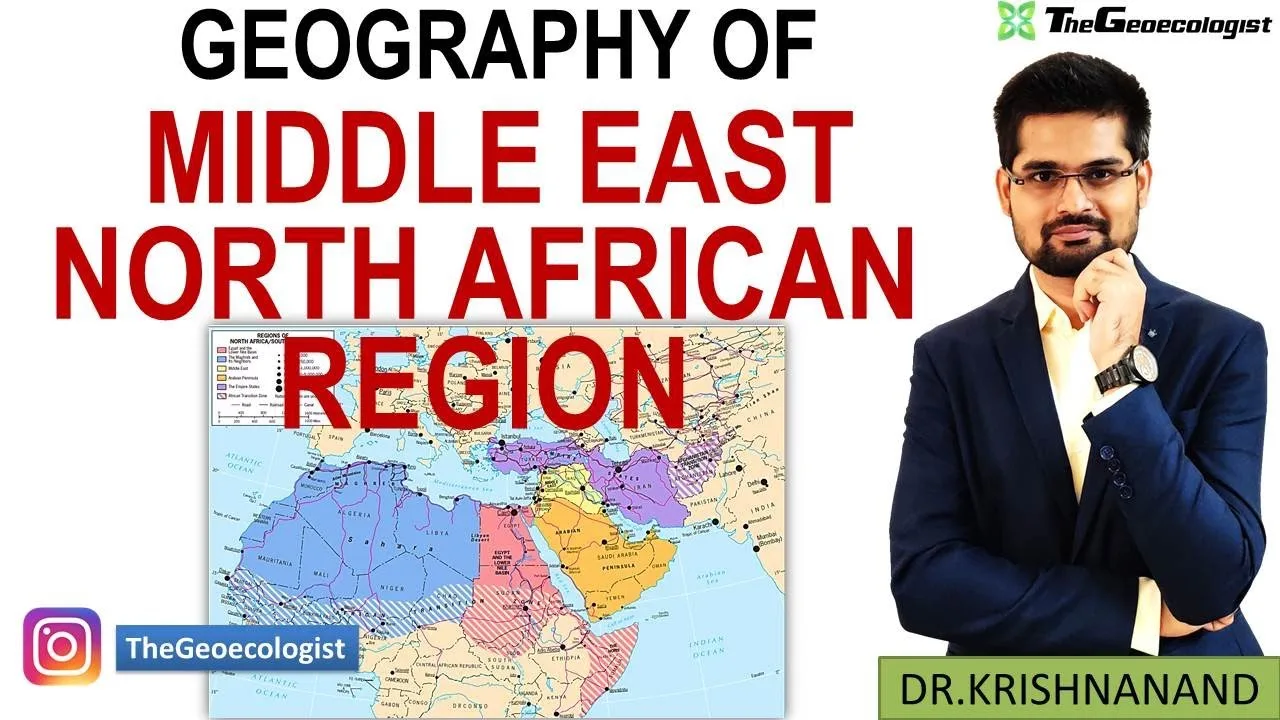
Table of Contents
- Physical Geography of the MENA Realm: Deserts, Mountains, and River Systems
- Arid Landscapes and Major Deserts
- Mountain Systems: Orographic Influences on Climate and Settlement
- River Systems: Lifelines in a Water-Scarce Realm
- Climate Dynamics: From Hyper-Aridity to Mediterranean Mildness
- Human and Cultural Geography: A Mosaic of Peoples and Faiths
- Ethno-Linguistic Diversity
- Religious Landscape: Cradle of Monotheism
- Geopolitical Economy: Hydrocarbons, Chokepoints, and Strategic Rivalries
- The Energy Heartland: Oil and Gas Dominance
- Maritime Chokepoints: Global Trade Arteries
- Conflict Zones: Colonial Legacies and Resource Competition
- Contemporary Challenges and Adaptive Innovations
- Water Scarcity: Crisis and Technological Response
- Urbanization and Megacity Pressures
- Youth Demographics: Demographic Dividend or Discontent?
- Regional Subdivisions: Maghreb, Mashriq, Gulf, and Levant
- Maghreb (Western Arab World)
- Mashriq (Eastern Arab World)
- Arabian Peninsula / Gulf
- Non-Arab Periphery: Turkey, Iran, Israel
- Environmental Futures: Climate Adaptation and Renewable Transitions
- Study Strategies for UPSC and Competitive Exams
- Conclusion: The MENA Realm as a Geographic Pivot
The MENA region geography encompasses a vast and strategically vital area stretching from the Atlantic shores of Morocco to the Arabian Peninsula’s eastern borders, bridging three continents—Africa, Asia, and Europe. This realm, formally known as the Middle East-North African (MENA) realm, represents one of the world’s most geographically diverse and geopolitically consequential regions. For UPSC aspirants, competitive exam candidates, and geography enthusiasts, mastering the MENA region geography is essential due to its intricate interplay of arid landscapes, hydrocarbon wealth, water scarcity challenges, and cultural mosaic. Dr. Krishnanand, founder of TheGeoecologist, provides expert analysis of this realm through his educational content, making complex geographical concepts accessible for examination preparation.
- Strategic Location: The MENA realm connects Africa, Asia, and Europe, controlling critical maritime chokepoints like the Suez Canal, Strait of Hormuz, and Bab-el-Mandeb.
- Resource Dominance: Over 50% of global proven oil reserves and 40% of natural gas reserves are concentrated in Gulf countries.
- Climate Extremes: Predominantly hot desert climate (BWh) with hyper-aridity; Mediterranean margins receive winter rainfall.
- Water Stress: The region hosts 6% of world population but only 1% of renewable freshwater resources, driving desalination innovation.
- Demographic Youth Bulge: Median age under 25 in many nations creates both economic opportunity and employment challenges.
- Cultural Cradle: Birthplace of Judaism, Christianity, and Islam; home to Arabs, Persians, Kurds, Berbers, and numerous minorities.
Physical Geography of the MENA Realm: Deserts, Mountains, and River Systems
Arid Landscapes and Major Deserts
The MENA region geography is fundamentally defined by aridity. The Sahara Desert, Earth’s largest hot desert covering approximately 9.2 million square kilometers, dominates North Africa. Its ergs (sand seas), hamadas (rocky plateaus), and regs (gravel plains) create formidable barriers to human settlement. To the east, the Arabian Desert extends across the peninsula, featuring the Rub’ al Khali (Empty Quarter)—the world’s largest continuous sand body at 650,000 sq km. These deserts are not static; aeolian processes constantly reshape dunes, while occasional flash floods carve wadis (ephemeral channels). Understanding these desert geomorphologies is crucial for MENA region geography examinations.
Mountain Systems: Orographic Influences on Climate and Settlement
Mountain ranges punctuate the arid expanse, creating localized climatic oases. The Atlas Mountains—comprising the High Atlas, Middle Atlas, and Anti-Atlas—stretch 2,500 km across Morocco, Algeria, and Tunisia. Jbel Toubkal (4,167 m) is North Africa’s highest peak. These mountains intercept Mediterranean moisture, enabling agriculture on windward slopes. In the east, the Zagros Mountains span 1,600 km across Iran and Iraq, forming a formidable barrier that influences the MENA region geography by creating rain-shadow deserts on their leeward side. The Taurus Mountains in Turkey and the Asir Mountains in southwestern Arabia further diversify the topographic template.
River Systems: Lifelines in a Water-Scarce Realm
Despite pervasive aridity, three major river systems sustain civilization. The Nile, at 6,650 km the world’s longest river, flows northward through eleven countries, its delta and valley hosting over 95% of Egypt’s population. The Tigris-Euphrates system, originating in eastern Turkey, defines Mesopotamia—the “cradle of civilization”—supporting ancient Sumer, Babylon, and modern Iraq. The Jordan River, though modest at 251 km, holds immense hydropolitical significance for Israel, Jordan, Palestine, Lebanon, and Syria. These rivers exemplify how MENA region geography transforms scarce water into concentrated human activity, while simultaneously generating transboundary tensions.
Climate Dynamics: From Hyper-Aridity to Mediterranean Mildness
The MENA region geography exhibits remarkable climatic diversity despite its arid reputation. The Köppen classification identifies hot desert climate (BWh) across 70% of the realm, with annual precipitation often below 50 mm. Summer temperatures routinely exceed 45°C in Gulf cities like Basra and Kuwait City. However, the Mediterranean coastline—from the Levant to the Maghreb—enjoys a Csa climate with wet winters (300–800 mm) and dry summers, enabling olive, citrus, and cereal cultivation. Highland areas in the Atlas, Zagros, and Asir mountains experience cooler temperatures and occasional snowfall. Climate change intensifies these patterns: the IPCC projects 20% rainfall decline by 2100 for North Africa, while heatwave frequency has tripled since 1980. These shifts directly impact MENA region geography questions on environmental security and adaptation.
Human and Cultural Geography: A Mosaic of Peoples and Faiths
Ethno-Linguistic Diversity
The MENA region geography hosts extraordinary cultural complexity. Arabs constitute the largest group, spanning from Morocco to Oman, yet significant minorities persist: Berbers (Amazigh) in Morocco (40% of population) and Algeria (25–30%), Kurds across Turkey, Iran, Iraq, and Syria (30–40 million), Persians in Iran (61%), Azeris in northwestern Iran (16%), and numerous smaller groups including Assyrians, Armenians, Circassians, and Domari. This diversity shapes political boundaries, language policies, and autonomy movements—key themes in MENA region geography curricula.
Religious Landscape: Cradle of Monotheism
As the birthplace of Judaism (c. 2000 BCE), Christianity (1st century CE), and Islam (7th century CE), the realm’s religious geography is foundational. Islam dominates demographically (90%+), with Sunni-Shia divisions influencing geopolitics—Iran’s Shia theocracy versus Sunni-majority Gulf monarchies. Christian communities, though diminished from 20% (1910) to ~5% today, remain in Lebanon (30–40%), Egypt (Coptic Orthodox, 10–15%), and Iraq. Jewish populations, once widespread across the Maghreb and Mashriq, now concentrate in Israel (6.9 million). Understanding this religious geography is indispensable for MENA region geography analysis.
Geopolitical Economy: Hydrocarbons, Chokepoints, and Strategic Rivalries
The Energy Heartland: Oil and Gas Dominance
The MENA region geography underpins global energy security. According to OPEC data, the realm holds 55.5% of world proven oil reserves (836 billion barrels) and 40.6% of natural gas reserves (79.4 trillion cubic meters). Saudi Arabia (267 billion barrels), Iran (208 billion), Iraq (145 billion), Kuwait (102 billion), and UAE (98 billion) lead reserves. This hydrocarbon wealth generates 60–90% of government revenues for Gulf Cooperation Council (GCC) states, shaping rentier state dynamics. However, the energy transition pressures diversification—Saudi Vision 2030, UAE Net Zero 2050, and Oman Vision 2040 exemplify post-oil strategies central to contemporary MENA region geography discourse.
Maritime Chokepoints: Global Trade Arteries
Three straits amplify the MENA region geography‘s strategic weight. The Suez Canal (193 km) handles 12% of global trade and 30% of container traffic, generating $7 billion annually for Egypt. The Strait of Hormuz (39 km narrowest point) transits 21 million bpd—20% of global oil consumption. The Bab-el-Mandeb (29 km) connects Red Sea to Gulf of Aden, critical for Europe-Asia shipping. Control over these chokepoints has triggered conflicts from the 1956 Suez Crisis to contemporary Houthi attacks on Red Sea shipping (2023–24). Any MENA region geography examination must address these maritime geographies.
Conflict Zones: Colonial Legacies and Resource Competition
The realm’s instability stems from overlapping drivers. The Sykes-Picot Agreement (1916) imposed artificial borders dividing ethnic groups. The Arab-Israeli conflict (1948–present) centers on territory, refugees, and Jerusalem. The Iran-Saudi proxy rivalry manifests in Yemen, Syria, Lebanon, and Iraq. Resource competition—water (Nile, Euphrates), oil (Kirkuk, Rumaila), and gas (Levant Basin)—exacerbates tensions. For UPSC aspirants, MENA region geography questions frequently link these conflicts to geographical determinants.
Contemporary Challenges and Adaptive Innovations
Water Scarcity: Crisis and Technological Response
With per capita renewable water below 500 m³/year (absolute scarcity threshold), the MENA region geography faces existential water stress. Desalination provides 70% of GCC potable water—Saudi Arabia’s Ras Al-Khair (1.025 million m³/day) and UAE’s Taweelah (909,000 m³/day) are world-leading plants. Israel recycles 90% of wastewater for agriculture. The Grand Ethiopian Renaissance Dam (GERD) on the Blue Nile epitomizes hydro-political tensions affecting Egypt and Sudan. These case studies are staples of MENA region geography curricula.
Urbanization and Megacity Pressures
Urban populations exceed 70% in most MENA states. Cairo (22 million), Tehran (16 million), Baghdad (8 million), and Riyadh (7.7 million) face housing deficits, traffic congestion, air pollution, and informal settlements. Dubai’s transformation from pearling village to global hub (3.6 million) illustrates rapid urbanization driven by MENA region geography‘s strategic location and capital investment. Smart city initiatives—NEOM (Saudi Arabia), Lusail (Qatar), New Administrative Capital (Egypt)—attempt to manage growth.
Youth Demographics: Demographic Dividend or Discontent?
With 60% of the population under 30, the MENA region geography presents a demographic window. However, youth unemployment averages 26% (world’s highest), reaching 40% in Libya and Palestine. Female labor participation remains low (19% vs. global 47%). Education systems struggle to align with market needs. The Arab Spring (2010–12) partly reflected this demographic-economic mismatch—a critical MENA region geography linkage.
Regional Subdivisions: Maghreb, Mashriq, Gulf, and Levant
Maghreb (Western Arab World)
Comprising Morocco, Algeria, Tunisia, Libya, and Mauritania, the Maghreb’s MENA region geography features Atlas Mountains, Mediterranean coastline, and Saharan interior. Historical trans-Saharan trade routes connected it to West Africa. French colonial legacy shapes institutions and language. The Arab Maghreb Union (1989) remains largely dormant due to Western Sahara dispute.
Mashriq (Eastern Arab World)
Egypt, Sudan, Levant states (Lebanon, Syria, Jordan, Palestine), and Iraq form the Mashriq. The Nile Valley and Fertile Crescent anchor its MENA region geography. Ancient civilizations—Pharaonic, Mesopotamian, Phoenician—left dense archaeological landscapes. Modern politics reflect Ottoman dissolution and mandate-era borders.
Arabian Peninsula / Gulf
GCC states (Saudi Arabia, UAE, Qatar, Kuwait, Bahrain, Oman) plus Yemen share peninsula MENA region geography. Hyper-aridity, vast hydrocarbon reserves, and tribal social structures define the subregion. Yemen’s distinct highland agriculture and conflict (2014–present) contrast with GCC wealth.
Non-Arab Periphery: Turkey, Iran, Israel
Turkey (Anatolian plateau, Bosporus control), Iran (Zagros/Elburz mountains, Persian identity), and Israel (coastal plain, Negev desert, technological economy) add geopolitical complexity. Their MENA region geography interactions—Turkey’s water leverage via Euphrates/Tigris headwaters, Iran’s Shia crescent strategy, Israel’s regional integration—shape contemporary dynamics.
Environmental Futures: Climate Adaptation and Renewable Transitions
The MENA region geography stands at climate change’s frontline. Temperature rise exceeds global average by 20%. Sea-level rise threatens Nile Delta (4 million at risk), Bahrain, and Qatar’s coastal cities. Dust storms increase in frequency—Iraq recorded 122 dust days in 2022. Yet the realm leads renewable deployment: Morocco’s Noor Ouarzazate (580 MW solar), UAE’s Mohammed bin Rashid Al Maktoum Solar Park (5 GW target), Saudi Arabia’s 58.7 GW renewables goal by 2030. Green hydrogen projects (NEOM, Duqm) leverage solar/wind potential. These transitions redefine MENA region geography‘s economic geography.
Study Strategies for UPSC and Competitive Exams
Mastering MENA region geography requires integrated preparation. Map practice is non-negotiable—locate deserts, mountains, rivers, chokepoints, oil fields, conflict zones, and capital cities. Link physical geography to human outcomes: how Zagros rain-shadow creates Khuzestan’s oil wealth; how Nile cataracts shaped Egyptian civilization; how Hormuz geography enables Iranian leverage. Track current affairs—GERD negotiations, Red Sea shipping attacks, OPEC+ decisions, COP climate commitments. Dr. Krishnanand’s lectures on TheGeoecologist channel provide structured coverage aligned with UPSC Geography Optional syllabus, emphasizing case studies, map-based questions, and interlinkages between physical, human, and economic geography.
Conclusion: The MENA Realm as a Geographic Pivot
The MENA region geography reveals a realm of profound contradictions: resource abundance amid water poverty, ancient civilizations beside futuristic cities, strategic centrality alongside persistent instability. Its deserts, mountains, and rivers have channeled human history for millennia; today, its hydrocarbons, chokepoints, and demographic youth shape global futures. For competitive exam aspirants, this geography offers high-yield topics spanning physical processes, resource geopolitics, environmental challenges, and cultural complexity. Engaging deeply with MENA region geography through authoritative resources like TheGeoecologist’s video lectures, standard texts (Khullar, Majid Husain), and current affairs integration ensures comprehensive preparation. The realm’s significance transcends examinations—it is a geographic pivot upon which 21st-century global order turns.
Frequently Asked Questions
The MENA (Middle East-North Africa) region typically includes 20–22 countries: Algeria, Bahrain, Egypt, Iran, Iraq, Israel, Jordan, Kuwait, Lebanon, Libya, Morocco, Oman, Qatar, Saudi Arabia, Syria, Tunisia, UAE, Palestine, Yemen, and sometimes Mauritania, Sudan, Turkey, and Afghanistan depending on the definition used by organizations like the World Bank or IMF.
The MENA region controls three critical maritime chokepoints—the Suez Canal, Strait of Hormuz, and Bab-el-Mandeb—through which approximately 30% of global container traffic and 20% of world oil consumption transit. Its location bridging Africa, Asia, and Europe makes it a strategic linchpin for international shipping and energy supply chains.
MENA is the world's most water-stressed region, with 6% of global population but only 1% of renewable freshwater. Per capita availability is below 500 m³/year (absolute scarcity). Key challenges include over-extraction of fossil aquifers, transboundary river disputes (Nile, Tigris-Euphrates, Jordan), climate-driven rainfall decline, and high desalination costs. Innovations like Israel's 90% wastewater recycling and GCC desalination capacity (70% of potable supply) are critical adaptations.