Blog
Bihar Flooding Causes: Why Floods Occur Despite Low Rainfall

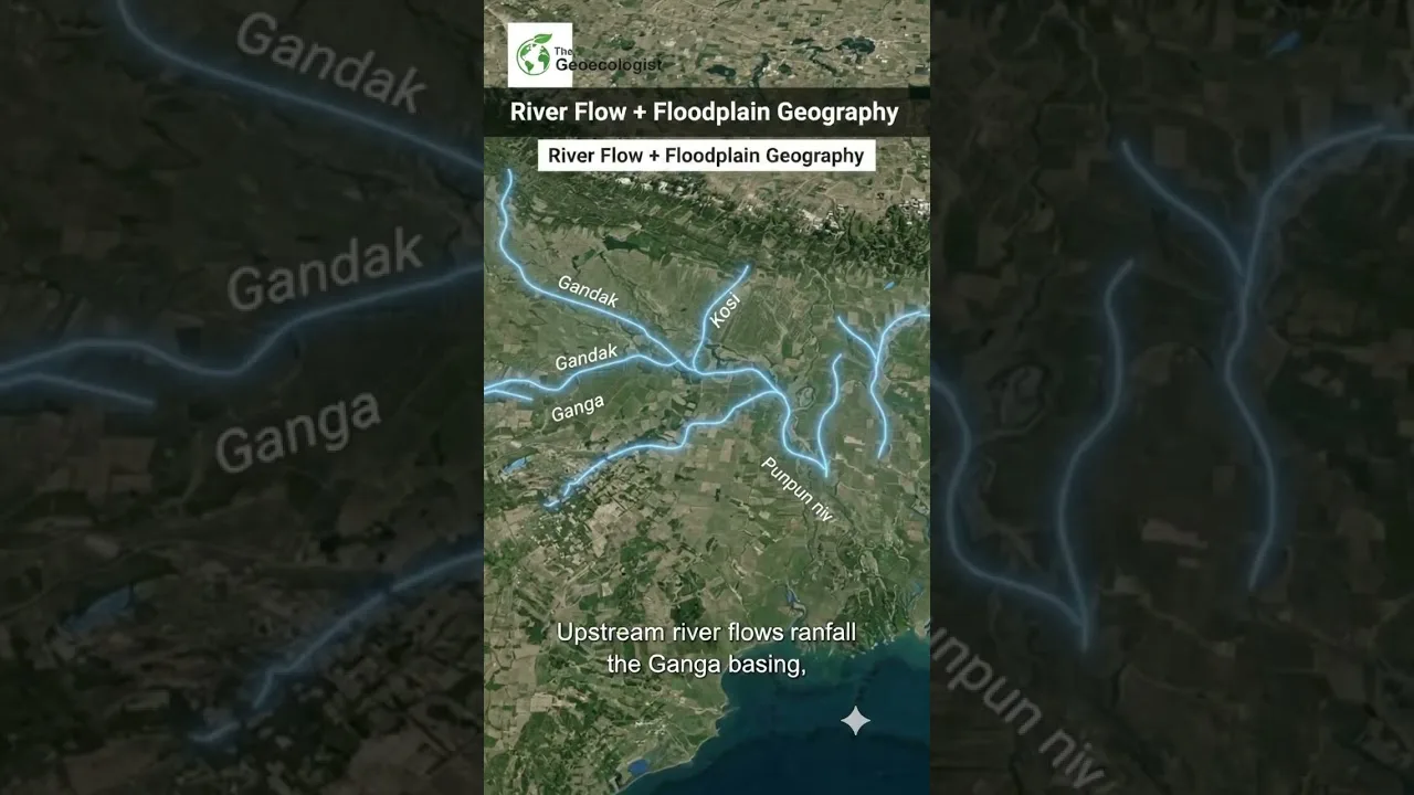
Table of Contents
- Understanding the Paradox of Bihar Flooding Causes
- The Role of the Himalayan Watershed in Bihar Flooding Causes
- Geographical and Topographical Drivers
- The Sedimentation Crisis
- The Influence of the Ganga Basin
- Impact on Communities and Infrastructure
- Comparing Local Rainfall vs. Basin Discharge
- The Role of Human Intervention and Embankments
- Climate Change and the Future of Bihar's Hydrology
- Strategies for Sustainable Flood Management
- Conclusion: A Call for Geographical Literacy
Understanding the Paradox of Bihar Flooding Causes
The phenomenon of Bihar flooding causes often baffles observers who monitor rainfall patterns. In recent years, Bihar has experienced severe inundations even during seasons when local precipitation remains below normal. This paradoxical situation highlights a critical geographical truth: the floods in Bihar are not merely a result of local rain, but are driven by a complex interplay of transboundary river systems, basin topography, and climate volatility. To understand why Bihar remains one of the most flood-prone regions in India, one must look beyond the clouds over Patna and toward the mountains of Nepal.
- Transboundary Water Flow: Most of Bihar’s floodwaters originate in the Nepal Himalayas.
- Topographical Slope: The steep gradient from the north to the south pushes water rapidly into the plains.
- River Morphometry: High sediment loads lead to riverbed elevation, reducing water-carrying capacity.
- Climate Change: Erratic rainfall patterns and glacial melt contribute to sudden surges.
The Role of the Himalayan Watershed in Bihar Flooding Causes
To analyze the primary Bihar flooding causes, we must examine the Kosi, Gandak, and Bagmati river systems. These are antecedent rivers that originate in the high-altitude regions of Nepal. Even if the state of Bihar experiences below-normal rainfall, intense precipitation in the catchment areas of Nepal can trigger catastrophic floods. When heavy rains hit the Himalayas, the water descends rapidly through steep gorges, gathering momentum and volume before entering the flat plains of the North Bihar region.
The Kosi River, often referred to as the “Sorrow of Bihar,” is a prime example. The Kosi is notorious for its shifting course. Over the last century, it has migrated westward by over 100 kilometers. This lateral migration is driven by the massive amount of silt and sediment the river carries from the mountains. As the riverbed rises due to sedimentation, the water easily breaches embankments, leading to widespread devastation regardless of local rainfall levels.
Geographical and Topographical Drivers

Geography plays a decisive role in the Bihar flooding causes. The state is situated in the lower reaches of the Ganga basin. The terrain is predominantly flat, meaning that once water enters the plains, it has very little natural slope to facilitate a quick exit toward the Bay of Bengal. This results in “waterlogging,” where water stagnates for weeks, submerging entire villages and destroying crops.
The Sedimentation Crisis
One of the most overlooked Bihar flooding causes is the high sediment load. The rivers flowing from the Himalayas carry vast quantities of alluvium. When these rivers hit the plains of Bihar, their velocity drops, causing the sediment to settle on the riverbed. This process, known as aggradation, raises the level of the riverbed above the surrounding land. Consequently, even a moderate volume of water can cause the river to overflow its banks, creating a flood scenario even during a drought-like local monsoon.
The Influence of the Ganga Basin
The Ganga river acts as the primary artery for the region. However, during the monsoon, the Ganga often reaches its maximum capacity. When tributary rivers like the Gandak or Kosi attempt to discharge their waters into the Ganga, they encounter a “backwater effect.” Because the Ganga is already full, the tributaries cannot drain efficiently, forcing the water to spread laterally across the floodplains. This systemic failure is a core component of the Bihar flooding causes that affect millions of residents annually.
Impact on Communities and Infrastructure
The consequences of these Bihar flooding causes are catastrophic. Every year, thousands of hectares of agricultural land are submerged. For a state heavily dependent on agriculture, this leads to severe economic instability and food insecurity. The disruption of transport networks—roads and bridges being washed away—isolates rural populations from emergency medical services and government aid.
According to reports from the National Disaster Management Authority (NDMA), the recurring nature of these floods has created a cycle of poverty. Families invest in rebuilding their homes only for them to be swept away in the next cycle, preventing long-term capital accumulation in the rural economy.
Comparing Local Rainfall vs. Basin Discharge
It is essential to distinguish between ‘pluvial floods’ (caused by local rain) and ‘fluvial floods’ (caused by river overflow). The Bihar flooding causes are predominantly fluvial. While pluvial flooding occurs when the ground cannot absorb local rain, fluvial flooding occurs when the river channel’s capacity is exceeded. Because Bihar is the recipient of water from a vast catchment area spanning thousands of square kilometers in Nepal and India, the local rainfall statistics are often irrelevant to the actual flood risk. A ‘dry’ June in Bihar can still be followed by a ‘wet’ July if the Nepalese highlands receive heavy precipitation.
The Role of Human Intervention and Embankments
In an attempt to mitigate the Bihar flooding causes, the government has constructed extensive embankment systems. While these walls are intended to keep rivers within their channels, they have often exacerbated the problem. Embankments prevent the natural deposition of silt on the floodplains, forcing the sediment to settle within the riverbed. This further raises the riverbed level, making any eventual breach far more destructive than a natural flood would have been.
Furthermore, the encroachment of floodplains for residential and commercial construction has reduced the natural “sponge” effect of the land. When the natural drainage channels are blocked by unplanned urbanization, the water has nowhere to go, intensifying the impact of the Bihar flooding causes on urban centers like Patna.
Climate Change and the Future of Bihar’s Hydrology
Climate change is introducing new variables into the Bihar flooding causes. We are seeing an increase in ‘cloudburst’ events in the Himalayan region. These extreme weather events dump massive amounts of water in a very short period, leading to flash floods that travel downstream into Bihar with terrifying speed. Additionally, the accelerated melting of Himalayan glaciers is increasing the base flow of the rivers, leaving less room for monsoon surges.
The volatility of the Indian Summer Monsoon (ISM) means that rainfall is becoming more concentrated. Instead of steady rain over three months, Bihar may experience two weeks of extreme precipitation followed by a month of drought. This erraticism makes traditional flood forecasting difficult and increases the vulnerability of the population.
Strategies for Sustainable Flood Management
Addressing the Bihar flooding causes requires a shift from ‘flood control’ to ‘flood management.’ Rather than trying to stop the water with walls, the focus should be on living with the water. This includes:
- Inter-state and International Cooperation: Collaborative water management treaties between India and Nepal to ensure real-time data sharing on water levels.
- Dredging and Desilting: Regularly removing sediment from riverbeds to restore their carrying capacity.
- Flood-Resilient Infrastructure: Building houses on stilts (plinth level raising) and developing flood-resistant crop varieties.
- Wetland Restoration: Protecting and restoring natural oxbow lakes and marshes that act as reservoirs during peak flows.
By understanding the systemic Bihar flooding causes, policymakers can move toward a more holistic approach. The integration of GIS (Geographic Information Systems) and satellite monitoring can provide early warnings, allowing communities to evacuate before the water arrives.
Conclusion: A Call for Geographical Literacy
The tragedy of the floods in Bihar is a reminder that environment and geography dictate the destiny of human settlements. The Bihar flooding causes are not a mystery of nature but a result of specific topographical and hydrological conditions. When we stop asking why it is flooding despite low rain and start asking how the basin dynamics work, we can begin to implement lasting solutions.
For students preparing for the UPSC examination or those interested in environmental science, the case of Bihar serves as a masterclass in fluvial geomorphology. Understanding the Bihar flooding causes is the first step toward building a resilient future for the millions who call the plains of the Ganga their home.
Frequently Asked Questions
Bihar flooding causes are primarily driven by transboundary rivers originating in Nepal. Heavy rainfall in the Himalayan catchment areas flows downstream into Bihar, causing floods regardless of local precipitation.
The Kosi River is known as the 'Sorrow of Bihar' because of its tendency to change its course frequently and carry massive amounts of sediment, which raises the riverbed and leads to frequent breaches.
Rivers carry silt from the mountains that settles in the flat plains of Bihar. This raises the riverbed (aggradation), reducing the channel's capacity to hold water and making it easier for rivers to overflow.