Blog
Atmospheric Circulation: NCERT Class 11 Guide

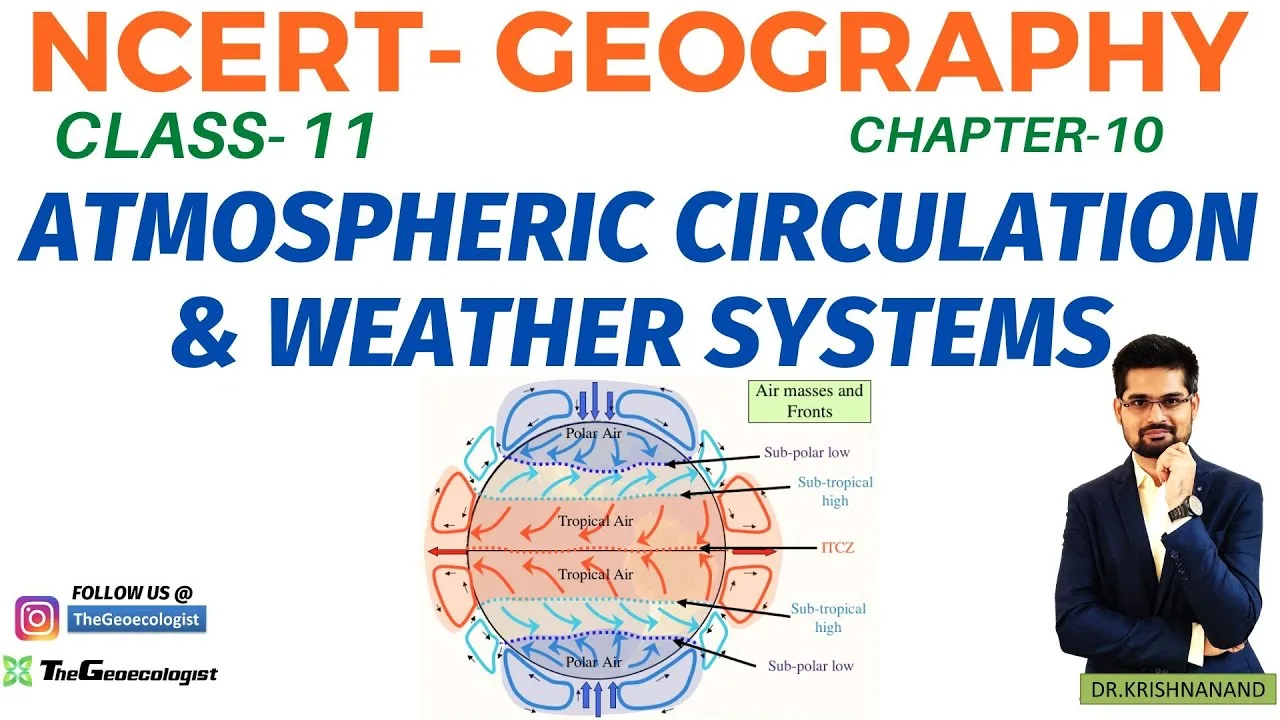
Table of Contents
- Atmospheric Circulation: The Three-Cell Model
- Hadley Cell
- Ferrel Cell
- Polar Cell
- Pressure Belts and Wind Systems
- Weather Systems: ITCZ, Jet Streams, Cyclones
- Inter‑Tropical Convergence Zone (ITCZ)
- Jet Streams
- Cyclones and Anticyclones
- Monsoons and Regional Winds
- Indian Monsoon
- Local Winds: Loo and Kal Baisakhi
- Why This Chapter Matters for Exams
- Study Tips and Resources
Atmospheric Circulation is the fundamental process that drives Earth’s weather and climate systems, shaping everything from daily breezes to massive monsoonal rains.
- Atmospheric Circulation explains global wind patterns, pressure belts, and the three-cell model.
- Key topics include the Inter‑Tropical Convergence Zone (ITCZ), jet streams, cyclones, anticyclones, and monsoons.
- Understanding this chapter is vital for CBSE board exams, UPSC geography, and competitive tests.
- Visual learning tools such as flowcharts and mnemonics improve retention.
- Real‑world case studies (e.g., Cyclone Amphan, Indian monsoon 2022) link theory to practice.
Atmospheric Circulation: The Three-Cell Model
The concept of Atmospheric Circulation begins with uneven solar heating. The equator receives more energy than the poles, creating temperature gradients that set air in motion. Earth’s rotation then deflects these moving air masses via the Coriolis effect, resulting in distinct circulation cells. The three‑cell model—Hadley, Ferrel, and Polar—remains the cornerstone for explaining global wind belts and pressure systems.
Hadley Cell
Located between the equator and approximately 30° latitude in both hemispheres, the Hadley Cell is the strongest of the three. Warm, moist air rises at the equator, creating a low‑pressure zone. As Atmospheric Circulation ascends, it cools, releases latent heat, and moves poleward at high altitudes. Around 30° latitude, the air descends, forming subtropical high‑pressure belts. The returning surface flow from these highs toward the equator constitutes the trade winds, which blow from the northeast in the Northern Hemisphere and from the southeast in the Southern Hemisphere. This cell is responsible for the tropical rainforests and deserts at the horse latitudes.
Ferrel Cell
The Ferrel Cell operates between 30° and 60° latitude and acts as a middle‑ground zone where surface winds are predominantly westerlies. Unlike the Hadley and Polar cells, the Ferrel Cell is indirect: air moves poleward near the surface, rises at around 60° latitude, moves equatorward aloft, and descends near 30°. This cell mediates the exchange of heat between the tropical and polar regions and gives rise to the prevailing westerlies that influence weather across North America, Europe, and Asia. – a key consideration for Atmospheric Circulation.
Polar Cell
Extending from 60° latitude to the poles, the Polar Cell is characterized by cold, dense air sinking at the poles and flowing equatorward at the surface as polar easterlies. At around 60° latitude, this air rises, creating the subpolar low‑pressure belt, and then moves poleward aloft to complete the circuit. Though weaker than the Hadley Cell, the Polar Cell plays a crucial role in shaping polar climates and the formation of polar fronts.
Pressure Belts and Wind Systems
Atmospheric Circulation establishes a series of alternating pressure belts that govern global wind patterns. Starting at the equator, the equatorial low (or doldrums) is a zone of converging trade winds and frequent thunderstorms. Moving poleward, the subtropical highs at about 30° latitude produce calm, dry conditions—historically known as the horse latitudes. The subpolar lows near 60° latitude are associated with mid‑latitude cyclones, while the polar highs dominate the Arctic and Antarctic regions. These belts shift seasonally due to the migration of the Sun’s zenith, influencing monsoonal systems and storm tracks.
Wind systems arise from the pressure gradient force (differences in pressure) and are deflected by the Coriolis effect. The trade winds (easterlies) flow from the subtropical highs toward the equatorial low, the westerlies flow from the subtropical highs toward the subpolar lows, and the polar easterlies flow from the polar highs toward the subpolar lows. Understanding these relationships is essential for interpreting weather maps and forecasting.
Weather Systems: ITCZ, Jet Streams, Cyclones
While Atmospheric Circulation sets the background flow, transient weather systems develop atop this framework. The Inter‑Tropical Convergence Zone (ITCZ) is a low‑pressure belt where the northern and southern trade winds converge. Its seasonal migration drives the onset and retreat of monsoons, particularly the Indian monsoon. Jet streams are fast‑flowing, narrow air currents in the upper troposphere (around 9–12 km altitude). The subtropical jet stream (around 30° latitude) and the polar jet stream (around 60° latitude) steer extratropical cyclones and influence the intensity of western disturbances that bring winter precipitation to North India.
Inter‑Tropical Convergence Zone (ITCZ)
The ITCZ appears as a band of clouds and thunderstorms encircling the globe near the equator. Its position follows the Sun’s apparent motion: during the Northern Hemisphere summer, the ITCZ shifts northward, enhancing rainfall over South Asia and West Africa; during the Southern Hemisphere summer, Atmospheric Circulation moves southward, affecting northern Australia and South America. For UPSC aspirants, linking ITCZ shifts to monsoon variability is a frequently tested concept.
Jet Streams
Jet streams are core components of upper‑atmospheric dynamics. The subtropical jet stream, formed due to the conservation of angular momentum, typically exhibits wind speeds of 100–200 km/h. The polar jet stream, stronger and more variable, can exceed 300 km/h during deep troughs. These streams guide the movement of mid‑latitude cyclones, determine the severity of cold waves, and influence the formation of clear‑air turbulence important for aviation.
Cyclones and Anticyclones
Cyclones are low‑pressure systems with inward spiraling winds, while anticyclones are high‑pressure systems with outward spiraling winds. Tropical cyclones (e.g., hurricanes, typhoons) develop over warm ocean waters (>26.5 °C) and require sufficient Coriolis force, typically forming between 5° and 20° latitude. They derive energy from latent heat release during condensation. Temperate (extratropical) cyclones form along polar fronts where warm and cold air masses interact, producing fronts and associated precipitation. Anticyclones bring settled weather, clear skies, and often contribute to heat waves or cold spells depending on their origin.
Monsoons and Regional Winds
The Indian monsoon exemplifies how Atmospheric Circulation interacts with land‑sea thermal contrasts. Intense heating of the Indian subcontinent creates a strong low‑pressure zone, drawing in moisture‑laden winds from the Indian Ocean. The seasonal northward shift of the ITCZ and the positioning of the subtropical jet stream further enhance monsoon strength. Local winds such as the Loo (hot, dry winds sweeping the plains of North India in May‑June) and Kal Baisakhi (nor’westers causing thunderstorms in West Bengal and Assam) are direct manifestations of regional pressure gradients and instability.
Indian Monsoon
The monsoon season accounts for approximately 75‑80 % of India’s annual rainfall. Onset typically occurs over Kerala around June 1, advancing northward over the next six weeks. The monsoon’s variability is linked to phenomena like El Niño‑Southern Oscillation (ENSO), Indian Ocean Dipole (IOD), and Eurasian snow cover. Accurate prediction of monsoon behavior is critical for agricultural planning, water resource management, and disaster preparedness.
Local Winds: Loo and Kal Baisakhi
The Loo forms when a strong low‑pressure system develops over northwestern India, drawing hot, dry air from the Thar Desert. Temperatures can exceed 45 °C, posing health risks. Kal Baisakhi, also known as Nor’westers, emerges from the collision of warm, moist air from the Bay of Bengal with cold, dry air from the northwest, producing violent thunderstorms, hail, and squalls in eastern India during the pre‑monsoon months.
Why This Chapter Matters for Exams
For CBSE Class 11 Geography, direct questions often ask students to label the three‑cell model, identify pressure belts, or explain the formation of trade winds and westerlies. Diagram‑based questions are common, making Atmospheric Circulation essential to reproduce neat sketches of Hadley, Ferrel, and Polar cells. In UPSC and other competitive examinations, the chapter’s relevance extends to climatology, environmental geography, and disaster management. Questions may link Atmospheric Circulation to monsoon failures, cyclone frequency, or jet‑stream‑induced western disturbances affecting Indian winters.
Study Tips and Resources
Effective mastery of Atmospheric Circulation requires a blend of visual, mnemonic, and applied learning strategies:
- Visual Learning: Create flowcharts that show air movement from equator to poles, labeling pressure belts and wind directions.
- Mnemonics: Remember the subtropical highs as “Horse Latitudes” – where sailing ships historically stalled.
- Case Studies: Relate theoretical concepts to recent events: Cyclone Amphan (2020) for tropical cyclone formation, the 2022 Indian monsoon excess for ITCZ behavior, and the 2023 winter western disturbances for jet stream impacts.
- Revision: Use NCERT summary tables and practice previous‑year question papers to reinforce recall.
- Supplementary Resources: Refer to authoritative sources such as the Wikipedia article on Atmospheric Circulation for detailed diagrams, and the Monsoon overview for regional applications.
By integrating these techniques, students can confidently tackle both theoretical and application‑based questions, ensuring strong performance in board exams and competitive tests.
Frequently Asked Questions
The three-cell model divides global atmospheric circulation into the Hadley Cell (equator to 30°), Ferrel Cell (30°–60°), and Polar Cell (60° to poles), explaining trade winds, westerlies, and polar easterlies.
The seasonal northward shift of the Inter‑Tropical Convergence Zone (ITCZ) draws moist winds onto the Indian subcontinent, triggering the onset of the summer monsoon.
Jet streams steer mid‑latitude cyclones and western disturbances, influencing precipitation patterns, temperature extremes, and aviation routes.