Blog
Hydrological Cycle: Components, Processes & UPSC Relevance

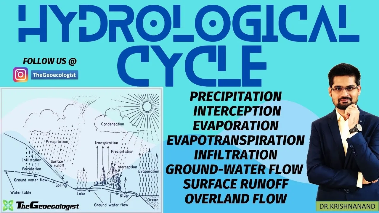
Table of Contents
- What Is the Hydrological Cycle? A Scientific Overview
- Six Core Components of the Hydrological Cycle
- 1. Evaporation: The Primary Flux from Surface to Atmosphere
- 2. Transpiration: The Biological Pump
- 3. Condensation: Cloud Formation and Latent Heat Release
- 4. Precipitation: The Return Flux
- 5. Infiltration: Groundwater Recharge
- 6. Runoff: Surface Flow Completing the Cycle
- Key Processes Governing the Hydrological Cycle
- Storage and Flux: Reservoirs and Turnover
- Sublimation: Ice-to-Vapor Transition
- Advection: Horizontal Moisture Transport
- Hydrological Cycle in Geography, Geology & Disaster Management
- Physical Geography: Climate, Ecosystems & Water Security
- Geology: Groundwater, Erosion & Sediment Transport
- Disaster Management: Floods, Droughts & Landslides
- Relevance of the Hydrological Cycle for UPSC Aspirants
- Geography Optional (Paper I): Climatology & Geomorphology
- GS Paper I (Prelims & Mains): Water Resources, Climate Change, Disasters
- Essay & Ethics: Intergenerational Equity & Water Governance
- Modern Tools for Studying the Hydrological Cycle
- Satellite Remote Sensing
- Isotope Hydrology
- Land Surface & Hydrological Models
- Simplified Learning with TheGeoecologist
- Conclusion: The Hydrological Cycle as a Planetary Life-Support System
The hydrological cycle is the continuous movement of water on, above, and below the surface of the Earth. This fundamental geophysical process governs the distribution of freshwater resources, shapes climate patterns, and sustains all terrestrial ecosystems. For students of geography, geology, environmental science, and competitive examinations like the UPSC, a deep understanding of the hydrological cycle is indispensable. This comprehensive guide breaks down the components, processes, storage reservoirs, and real-world applications of the water cycle, integrating academic theory with practical relevance for disaster management and policy-making.
- The hydrological cycle comprises six major components: evaporation, transpiration, condensation, precipitation, infiltration, and runoff.
- Key processes include storage in reservoirs, flux between reservoirs, sublimation, and advection of water vapor.
- Approximately 97.5% of Earth’s water is saline; only 2.5% is freshwater, of which 68.7% is locked in ice caps and glaciers.
- Understanding the hydrological cycle is critical for predicting floods, droughts, and landslides — core topics in disaster management.
- For UPSC aspirants, the water cycle is a high-yield topic in Geography Optional (Paper I), GS Paper I, and Essay papers.
What Is the Hydrological Cycle? A Scientific Overview
The hydrological cycle (also known as the water cycle) describes the unending circulation of water between the atmosphere, lithosphere, hydrosphere, and biosphere. Powered primarily by solar radiation and gravity, this cycle has no beginning or end. Water changes phase — liquid, solid, gas — as it moves through various reservoirs: oceans (97% of total water), ice caps, groundwater, lakes, rivers, soil moisture, and the atmosphere. The global water balance is remarkably stable over long timescales, but regional and temporal variations drive weather extremes, water scarcity, and geomorphic change.
According to the U.S. Geological Survey (USGS), the total volume of water on Earth is about 1.386 billion cubic kilometers. Of this, only about 0.3% is readily accessible surface freshwater. The residence time of water varies dramatically: 3,200 years in the oceans, 20–100 years in groundwater, 17 years in ice caps, and just 9 days in the atmosphere. These residence times dictate how quickly the hydrological cycle responds to climatic forcings.
Six Core Components of the Hydrological Cycle
Each component of the hydrological cycle represents a distinct phase transition or transport mechanism. Together, they form a closed mass-balance system.
1. Evaporation: The Primary Flux from Surface to Atmosphere
Evaporation is the phase change from liquid water to water vapor, driven by solar energy. Oceans contribute ~86% of global evaporation (~434,000 km³/yr). Factors influencing evaporation rates include temperature, wind speed, humidity, and surface area. The latent heat of vaporization (2,260 kJ/kg at 100°C) makes evaporation a massive heat-transfer mechanism, cooling the surface and energizing atmospheric convection. Pan evaporation data from meteorological stations worldwide show a paradoxical decline in many regions despite warming — attributed to reduced solar radiation (“global dimming”) and decreased wind speeds.
2. Transpiration: The Biological Pump
Transpiration is the release of water vapor from plant stomata during photosynthesis. Combined with evaporation, it forms evapotranspiration (ET). Globally, transpiration accounts for ~10% of atmospheric moisture (~40,000 km³/yr). Forests, with deep root systems and high leaf area index, recycle rainfall efficiently — the Amazon rainforest generates up to 50% of its own precipitation through moisture recycling. Deforestation disrupts this feedback, reducing regional rainfall and extending dry seasons.
3. Condensation: Cloud Formation and Latent Heat Release
As moist air rises and cools adiabatically, water vapor condenses onto cloud condensation nuclei (CCN) — aerosols like sea salt, sulfates, and dust. This phase change releases latent heat, fueling storm systems, cyclones, and the Hadley circulation. The hydrological cycle thus couples thermodynamics and dynamics: condensation heating drives vertical motion, which sustains further condensation. Cloud microphysics — droplet coalescence, ice crystal growth (Bergeron process) — determines precipitation efficiency.
4. Precipitation: The Return Flux
Precipitation (rain, snow, sleet, hail) returns water to the surface. Global mean precipitation is ~990 mm/yr (~505,000 km³/yr), balancing evaporation. Spatial distribution is highly uneven: tropical convergence zones receive >3,000 mm/yr, while subtropical deserts receive <100 mm/yr. Orographic lifting enhances precipitation on windward slopes (e.g., Western Ghats, Himalayas), creating rain shadows. Climate change intensifies the hydrological cycle: a 1°C warming increases atmospheric moisture-holding capacity by ~7% (Clausius–Clapeyron relation), leading to heavier extreme rainfall events.
5. Infiltration: Groundwater Recharge
Infiltration is the entry of water into the soil profile. It depends on soil texture, structure, vegetation cover, antecedent moisture, and rainfall intensity. Infiltrated water percolates downward, recharging aquifers — the largest accessible freshwater reservoir (~10.5 million km³). Over-extraction of groundwater (e.g., in Northwest India, California’s Central Valley, North China Plain) exceeds natural recharge, causing water-table decline, land subsidence, and saltwater intrusion. Managed aquifer recharge (MAR) and watershed interventions (check dams, contour trenching) enhance infiltration.
6. Runoff: Surface Flow Completing the Cycle
Runoff — overland flow and channel flow — transports water back to oceans. It includes surface runoff (Hortonian, saturation-excess), interflow, and baseflow (groundwater discharge to streams). The runoff coefficient (runoff/precipitation) ranges from 0.8 in urbanized or impervious catchments. River discharge integrates basin-scale hydrological cycle responses. Major rivers like the Ganga-Brahmaputra-Meghna system discharge ~1,100 km³/yr, supporting dense populations but also generating catastrophic floods.
Key Processes Governing the Hydrological Cycle

Beyond the six components, several cross-cutting processes regulate the magnitude, timing, and pathways of water movement.
Storage and Flux: Reservoirs and Turnover
The hydrological cycle operates through storage reservoirs (stocks) and fluxes (flows). Major reservoirs: oceans (1,338,000 km³), ice caps/glaciers (24,064 km³), groundwater (23,400 km³), lakes (176 km³), soil moisture (16.5 km³), atmosphere (12.9 km³), rivers (2.12 km³). Fluxes: evaporation (505,000 km³/yr), precipitation (505,000 km³/yr), runoff (39,800 km³/yr). Turnover time = storage/flux. Rapid turnover in atmosphere (9 days) makes weather unpredictable beyond 2 weeks; slow turnover in deep groundwater (millennia) buffers climate variability.
Sublimation: Ice-to-Vapor Transition
Sublimation — direct solid-to-gas phase change — occurs in cold, dry, windy environments: polar ice sheets, high mountain glaciers, and seasonal snowpack. It bypasses the liquid phase, returning water vapor directly to the atmosphere. In Antarctica, sublimation accounts for significant mass loss from ice sheets. On Himalayan glaciers, sublimation can exceed melt at high elevations. Sublimation is difficult to measure but critical for accurate glacier mass-balance and hydrological cycle modeling in cryospheric regions.
Advection: Horizontal Moisture Transport
Advection moves water vapor horizontally by wind. It connects evaporation sources to precipitation sinks across continents. The “atmospheric rivers” — narrow corridors of intense moisture transport — deliver ~90% of poleward moisture flux. For example, the Indian Summer Monsoon is driven by cross-equatorial flow advecting moisture from the Indian Ocean. Advection explains why precipitation over land (~110,000 km³/yr) exceeds land evaporation (~70,000 km³/yr): the deficit is supplied by oceanic moisture advection. Changes in circulation patterns (e.g., monsoon weakening, jet stream shifts) alter regional water availability.
Hydrological Cycle in Geography, Geology & Disaster Management
The hydrological cycle is a unifying framework across Earth sciences.
Physical Geography: Climate, Ecosystems & Water Security
Geographers analyze the spatial-temporal dynamics of the hydrological cycle to explain biome distribution (Köppen climate classification), river regime types (perennial, ephemeral), and human settlement patterns. Water scarcity indices (Falkenmark indicator: <1,700 m³/capita/yr = stress; <1,000 = scarcity) derive from cycle components. Virtual water trade — water embedded in food imports — globalizes the hydrological cycle. The Water Footprint Network quantifies green (rainfed), blue (irrigated), and grey (pollution assimilation) water footprints for products and nations.
Geology: Groundwater, Erosion & Sediment Transport
Geologists study how the hydrological cycle shapes the lithosphere. Groundwater flow dissolves carbonate rocks (karst), deposits minerals (hydrothermal veins), and drives diagenesis. Fluvial erosion and sediment transport — governed by stream power (ρgQS) — carve valleys, build deltas, and fill basins. The sediment flux to oceans (~20 Gt/yr) records tectonic and climatic history. Isotope hydrology (δ¹⁸O, δ²H, ³H, ¹⁴C) traces water origin, age, and mixing — essential for paleoclimate reconstruction and groundwater management.
Disaster Management: Floods, Droughts & Landslides
Extremes in the hydrological cycle drive hydro-meteorological disasters. Floods result from excessive precipitation, rapid snowmelt, dam failures, or storm surges compounded by poor infiltration (urbanization, soil sealing). The 2018 Kerala floods (483% above normal rainfall in August) exemplify compound extremes: intense rainfall + saturated antecedent conditions + reservoir mismanagement. Droughts — meteorological (precipitation deficit), agricultural (soil moisture deficit), hydrological (streamflow/groundwater deficit), socioeconomic (water access failure) — propagate through the cycle with lag. The 2015–18 Cape Town “Day Zero” drought combined multi-year rainfall deficit with rising demand. Landslides are triggered when intense rainfall reduces soil shear strength via pore-pressure buildup. Early warning systems (e.g., India’s Flood Early Warning System, Global Flood Awareness System) integrate real-time hydrological cycle monitoring (satellite precipitation, soil moisture, river gauges) with hydraulic models.
Relevance of the Hydrological Cycle for UPSC Aspirants
The hydrological cycle is a cornerstone topic across multiple UPSC papers.
Geography Optional (Paper I): Climatology & Geomorphology
Questions on the hydrological cycle appear regularly in the Climatology section (e.g., “Discuss the role of the hydrological cycle in global heat budget,” 2019) and Geomorphology (e.g., “Explain the concept of drainage basin as a fundamental geomorphic unit in the context of the hydrological cycle,” 2017). Aspirants must master: water budget equation (P = E + R ± ΔS), potential vs. actual evapotranspiration (Thornthwaite, Penman-Monteith), hydrograph analysis (unit hydrograph, S-curve), and groundwater hydraulics (Darcy’s law, transmissivity, storativity). Diagrammatic representation of the hydrological cycle with annotated fluxes and reservoirs fetches high marks.
GS Paper I (Prelims & Mains): Water Resources, Climate Change, Disasters
Prelims MCQs test factual knowledge: “Which reservoir has the longest residence time in the hydrological cycle?” (Deep groundwater / Ice caps). Mains questions demand applied analysis: “Climate change is intensifying the hydrological cycle. Discuss implications for India’s water security” (2020). Linkages to El Niño–Southern Oscillation (ENSO), Indian Ocean Dipole (IOD), and monsoon variability are essential. The 2023 Mains question on “Glacial Lake Outburst Floods (GLOFs) in the Himalayas” requires understanding of cryospheric components of the hydrological cycle. Case studies — Kerala floods (2018), Chennai water crisis (2019), Joshimath subsidence (2023) — demonstrate applied knowledge.
Essay & Ethics: Intergenerational Equity & Water Governance
Essay topics like “Water: The Elixir of Life” or “Climate Justice and the Global South” demand a holistic view of the hydrological cycle as a common-pool resource. Ethics case studies on inter-state water disputes (Cauvery, Krishna, Sutlej-Yamuna Link) invoke principles of equitable utilization, no-harm rule, and prior notification — rooted in the physical reality of shared basins governed by the hydrological cycle.
Modern Tools for Studying the Hydrological Cycle
Advances in observation and modeling have revolutionized hydrological cycle science.
Satellite Remote Sensing
NASA’s GRACE and GRACE-FO missions measure terrestrial water storage anomalies (TWSA) via gravity changes, revealing groundwater depletion in Northwest India (~19.2 ± 1.1 Gt/yr, 2002–2008). GPM (Global Precipitation Mission) provides 30-min, 0.1° precipitation estimates. SMAP and Sentinel-1 monitor soil moisture. MODIS/VIIRS track snow cover, evapotranspiration (MOD16), and surface water extent. These datasets constrain hydrological cycle models at global to basin scales.
Isotope Hydrology
Stable isotopes (δ¹⁸O, δ²H) in precipitation, groundwater, and plant xylem water partition evaporation vs. transpiration, identify recharge sources, and quantify water transit times. The Global Network of Isotopes in Precipitation (GNIP, IAEA/WMO) provides decades of data. Isotope-enabled GCMs (e.g., ECHAM-wiso, LMDZ-iso) simulate the hydrological cycle with isotopic tracers, improving paleoclimate proxy interpretation.
Land Surface & Hydrological Models
Models like VIC, Noah-MP, CLM, and ParFlow-CLM simulate the hydrological cycle at grid scales. Coupled with GCMs (CMIP6), they project future changes: increased evapotranspiration, earlier snowmelt, reduced snowpack, more intense precipitation, and expanded arid zones. The IPCC AR6 (2021) states high confidence that the hydrological cycle will intensify, with wet regions getting wetter and dry regions drier — but regional uncertainties remain large due to circulation changes.
Simplified Learning with TheGeoecologist
Dr. Krishnanand, founder of TheGeoecologist, offers structured resources for mastering the hydrological cycle and related geography topics. His lecture series features:
- Visual Aids: Animated diagrams tracing water movement through reservoirs and fluxes.
- Real-World Examples: Linking theory to current events — monsoon dynamics, glacier retreat, urban flooding.
- Exam-Centric Approach: Previous year question analysis, answer-writing frameworks, and map-based case studies.
Recommended resource: The Simplified Hydrology E-Book (PDF) provides a concise, diagram-rich guide covering the complete hydrological cycle syllabus for UPSC Geography Optional and GS. For comprehensive courses, visit the TheGeoecologist website or contact via WhatsApp (9311052969). Follow @thegeoecologist on Instagram for daily geography updates.
Conclusion: The Hydrological Cycle as a Planetary Life-Support System
The hydrological cycle is far more than a textbook diagram — it is the circulatory system of the planet, distributing water, energy, and nutrients across the Earth system. Its components (evaporation, transpiration, condensation, precipitation, infiltration, runoff) and processes (storage-flux dynamics, sublimation, advection) operate across scales from pore to planet, seconds to millennia. For geographers, it explains spatial patterns of life and livelihood. For geologists, it is the agent of erosion, deposition, and crustal evolution. For disaster managers, its extremes define risk and resilience. And for UPSC aspirants, it is a high-return topic bridging static syllabus and dynamic current affairs.
As climate change accelerates, the hydrological cycle is shifting in ways that challenge water security, food systems, and ecological integrity. Mastering its science — and its representation in models, observations, and policy — is essential for any serious student of the Earth system. Leverage expert guidance from TheGeoecologist, engage with primary data (GRACE, GPM, GNIP), and practice integrating the hydrological cycle into answers on monsoons, groundwater, floods, droughts, and climate adaptation. The water cycle connects everything; understanding it connects you to the pulse of the planet.
Visit TheGeoecologist for affordable online courses and stay tuned to our YouTube channel for simplified geography lectures!
Frequently Asked Questions
The six main components are evaporation, transpiration, condensation, precipitation, infiltration, and runoff. Together they describe the continuous movement of water between Earth's surface and atmosphere.
Extremes in the hydrological cycle drive floods (excess precipitation, poor infiltration), droughts (prolonged deficits in precipitation and soil moisture), and landslides (intense rainfall increasing pore pressure). Understanding cycle dynamics enables prediction and early warning.
The hydrological cycle is a core topic in Geography Optional (Paper I), GS Paper I (Prelims and Mains), and Essay. It underpins questions on climatology, geomorphology, water resources, climate change, and disaster management — with frequent case-study-based questions.