

Blog
How GPS Works: A Comprehensive Guide to Satellite Navigation

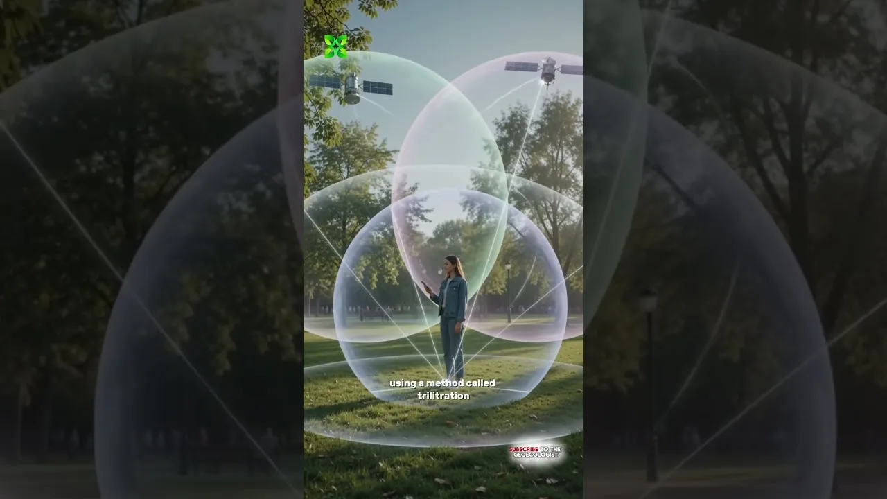
Table of Contents
Understanding how GPS works is essential in our modern, hyper-connected world where location-based services dictate everything from food delivery to autonomous driving. At its core, the Global Positioning System (GPS) is a satellite-based navigation system that allows anyone with a receiver to determine their exact location on Earth. Whether you are navigating a busy city street or tracking a flight across the Atlantic, the technology working behind the scenes is nothing short of a scientific marvel.
- Trilateration: The mathematical method used to determine position via satellite signals.
- Satellite Constellation: A network of at least 24 satellites ensuring global coverage.
- Time Synchronization: The critical role of atomic clocks in ensuring precision.
- Relativity: How Einstein’s theories prevent massive errors in positioning.
The Fundamental Science: How GPS Works for Everyone
To grasp the concept of how GPS works, one must first understand the concept of trilateration. Unlike triangulation, which uses angles, trilateration uses distances. Imagine you are lost in a desert. If a person tells you, “You are 50 miles from City A,” you know you are on a circle around that city. If a second person says, “You are 30 miles from City B,” your location is narrowed down to two points where those circles intersect. A third person provides a third distance, pinpointing your exact location. This is the fundamental logic of the GPS system.
The Global Positioning System is managed by the Global Positioning System, a constellation of satellites orbiting Earth. These satellites transmit continuous signals containing the time the signal was sent and the satellite’s precise position. Your smartphone or car GPS receiver picks up these signals and calculates the distance to each satellite based on the time it took for the signal to travel at the speed of light.
The Role of the Satellite Constellation
For the system to be reliable, there must be a constant line of sight between the receiver and the satellites. To ensure this, the US Department of Defense maintains a constellation of approximately 31 active satellites. These satellites are spread across different orbital planes, ensuring that no matter where you are on the planet, at least four satellites are visible at any given time. This redundancy is what makes how GPS works so robust and dependable for military and civilian use alike.
The satellites orbit at an altitude of approximately 20,200 kilometers. This specific height is chosen to balance the coverage area of each satellite with the signal strength required for a handheld device to receive it. Because the satellites are constantly moving, the receiver must constantly update its calculations to account for the changing geometry of the satellite network.
The Precision Problem: Why Atomic Clocks Matter
When discussing how GPS works, we cannot ignore the extreme precision required. Because signals travel at the speed of light (roughly 300,000 kilometers per second), even a tiny error in timing can lead to a massive error in location. A timing error of just one microsecond (one millionth of a second) would result in a positional error of about 300 meters.
To prevent this, every GPS satellite carries highly accurate atomic clocks. These clocks use the vibrations of atoms (usually cesium or rubidium) to keep time with incredible stability. Without these atomic clocks, the system would lose accuracy within minutes, making the concept of how GPS works entirely useless for navigation.
Einstein and the Relativity Factor
Perhaps the most fascinating aspect of how GPS works is that it must account for Albert Einstein’s theories of relativity. According to General Relativity, time moves faster in weaker gravitational fields (further from Earth). According to Special Relativity, time moves slower for objects moving at high speeds. Because the satellites are moving fast and are far from Earth’s gravity, their onboard clocks tick slightly faster than clocks on the ground.
If engineers did not program the satellites to compensate for these relativistic effects, the GPS system would accumulate errors of about 10 kilometers per day. This is a prime example of how theoretical physics is applied to everyday technology. Every time you use Google Maps, you are indirectly benefiting from Einstein’s groundbreaking work on space-time.
Common Challenges in Satellite Navigation
While the system is highly advanced, there are environmental factors that can interfere with how GPS works. One major factor is the ionosphere. The ionosphere is a layer of the Earth’s atmosphere filled with charged particles. As GPS signals pass through this layer, they are refracted (bent), which can introduce small delays in the signal’s arrival time.
Another challenge is the “Urban Canyon” effect. In dense cities with skyscrapers, the GPS signal can bounce off buildings before reaching your phone. This is known as multipath error. The receiver thinks the signal traveled a longer distance because of the bounce, leading to an inaccurate position. This is why your blue dot on a map sometimes jumps between streets in a city center.
GPS vs. GLONASS vs. Galileo
While many people use the term “GPS” generically, it actually refers specifically to the American system. Other nations have their own constellations. For example, Russia has the GLONASS system, and the European Union has Galileo. Understanding the differences in how GPS works compared to these systems is vital for high-precision industries like surveying or autonomous aviation. Most modern smartphones actually use a combination of all these signals to provide much higher accuracy through multi-constellation support.
The Future of Positioning Technology
As we move toward a future of self-driving cars and drone deliveries, the demand for even greater precision is growing. Future iterations of how GPS works will likely involve more frequent updates and even more precise atomic clocks. We are also seeing the rise of RTK (Real-Time Kinematic) technology, which uses ground-based reference stations to correct satellite errors in real-time, providing centimeter-level accuracy.
The integration of AI and machine learning is also beginning to play a role. AI can help predict and filter out multipath errors or ionospheric delays, making the determination of how GPS works even more seamless for the end user. As we look forward, the synergy between satellite technology and artificial intelligence will redefine global logistics and personal mobility.
In conclusion, the magic of how GPS works lies in the perfect marriage of geometry, physics, and engineering. From the orbits of satellites to the ticking of atomic clocks and the complex math of trilateration, it is a testament to human ingenuity. Next time you check your location on your phone, remember the incredible journey that signal took to find you.
Frequently Asked Questions
A minimum of four satellites is required to determine a 3D position (latitude, longitude, and altitude) via trilateration.
GPS signals are relatively weak and can be blocked by thick walls or concrete, often leading to poor accuracy or no signal indoors.
Relativity affects how time passes for satellites. Without correcting for these time differences, GPS location data would become inaccurate very quickly.
