
Blog
Dharali Cloudburst: Devastation in Uttarkashi Harshil Valley

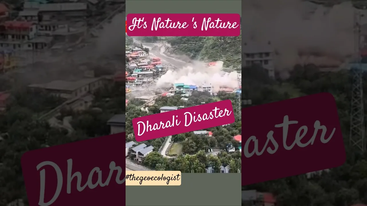
Table of Contents
- What Happened During the Dharali Cloudburst
- Timeline of the Disaster
- Geography of Harshil Valley and Kheer Ganga
- Understanding Cloudbursts: Science Behind the Disaster
- Why Himalayan Cloudbursts Are Increasingly Deadly
- Impact on Infrastructure and Local Economy
- Tourism Sector Devastation
- Rescue Operations: NDRF and Multi-Agency Response
- Challenges in High-Altitude Rescue
- Climate Change and Himalayan Vulnerability
- Compounding Anthropogenic Factors
- Historical Context: Disasters in Uttarkashi District
- Lessons Unlearned from Previous Disasters
- Government Response and Relief Measures
- Toward Resilient Futures: Policy Imperatives
- Immediate Actions (0-6 Months)
- Medium-Term Reforms (6 Months – 3 Years)
- Long-Term Transformation (3-10 Years)
- Community Voices: The Human Dimension
- Conclusion: A Wake-Up Call for the Himalayas
The Dharali cloudburst that struck the picturesque Harshil Valley in Uttarkashi district on Tuesday has left a trail of unprecedented destruction, sweeping away hotels, shops, and restaurants while leaving numerous locals and tourists missing. This catastrophic event, triggered by a sudden cloudburst followed by flash floods from Kheer Ganga, has once again highlighted the extreme vulnerability of Uttarakhand’s Himalayan communities to climate-induced disasters.
- Location: Dharali village, Harshil Valley, Uttarkashi district, Uttarakhand
- Trigger: Cloudburst followed by flash floods and debris flow from Kheer Ganga
- Casualties: Multiple missing persons, feared fatalities, several injured
- Infrastructure Damage: Hotels, shops, restaurants, homes, and roads destroyed
- Response: NDRF, SDRF, local police, and volunteers deployed; rescue hampered by rainfall
- Broader Context: Part of increasing cloudburst frequency in Himalayas due to climate change
What Happened During the Dharali Cloudburst
On Tuesday morning, a massive Dharali cloudburst unleashed torrential rainfall over the Harshil Valley within an extremely short timeframe. The Indian Meteorological Department (IMD) defines a cloudburst as precipitation exceeding 100mm per hour over a localized area — a threshold that was catastrophically surpassed in this event. The sudden deluge triggered a violent debris slide from Kheer Ganga, a glacial stream that flows through the valley, transforming the peaceful mountain village into a disaster zone within minutes.
Eyewitness accounts describe a “wall of mud, boulders, and water” descending from the mountains at terrifying speed. The debris flow, carrying massive rocks and uprooted trees, slammed into structures along the riverbanks. Several hotels and restaurants popular with tourists visiting the Gangotri pilgrimage route were completely swept away. Local residents reported hearing a thunderous roar minutes before the impact, giving them barely enough time to flee to higher ground. – a key consideration for Dharali cloudburst.
Timeline of the Disaster
- Early Morning: Intense rainfall begins over Harshil Valley
- Within 30 Minutes: Kheer Ganga swells beyond capacity, debris flow initiates
- Peak Impact: Flash flood hits Dharali village, destroying riverbank structures
- Immediate Aftermath: Local volunteers begin search; district administration alerted
- Hours Later: NDRF and SDRF teams deployed; helicopter reconnaissance conducted
Geography of Harshil Valley and Kheer Ganga
Harshil Valley, situated at an elevation of approximately 2,620 meters (8,600 feet), lies on the banks of the Bhagirathi River — the headstream of the Ganges. The valley is a critical waypoint on the route to Gangotri, one of the four Char Dham pilgrimage sites. Dharali village, located just 3 kilometers from Harshil, sits in a geologically fragile zone characterized by steep slopes, glacial deposits, and active stream channels. – a key consideration for Dharali cloudburst.
Kheer Ganga, the stream responsible for the devastating debris flow, originates from glacial melt at higher altitudes. During the Dharali cloudburst, the stream’s catchment area received extreme precipitation, causing rapid runoff that mobilized vast quantities of loose glacial sediment. This phenomenon, known as a glacial lake outburst flood (GLOF) or debris flow, is particularly destructive because the slurry of water, mud, and boulders behaves like wet concrete — capable of demolishing reinforced structures.
Understanding Cloudbursts: Science Behind the Disaster
A cloudburst is not merely heavy rain — Dharali cloudburst is a meteorological phenomenon where extreme precipitation occurs over a small geographic area in a very short duration. According to the World Meteorological Organization, cloudbursts typically involve rainfall rates exceeding 100mm per hour, often accompanied by thunderstorms and strong downdrafts. In the Himalayan context, orographic lifting — where moist air is forced upward by mountain topography — creates ideal conditions for these events.
The Dharali cloudburst exemplifies the classic Himalayan cloudburst mechanism: monsoon moisture from the Bay of Bengal travels northwest, encounters the steep Himalayan barrier, and undergoes rapid adiabatic cooling. This process can produce localized rainfall intensities that overwhelm natural drainage systems within minutes. Climate scientists at the Indian Institute of Tropical Meteorology have documented a statistically significant increase in extreme rainfall events over the western Himalayas since 1950, correlating with rising temperatures.
Why Himalayan Cloudbursts Are Increasingly Deadly
- Glacial Retreat: Receding glaciers leave behind unstable moraine deposits easily mobilized by rain
- Permafrost Thaw: Warming temperatures destabilize frozen ground on steep slopes
- Deforestation: Loss of forest cover reduces soil cohesion and increases runoff velocity
- Unplanned Construction: Buildings on floodplains and landslide-prone slopes amplify losses
- Tourism Pressure: Seasonal population surges increase exposure in hazard zones
Impact on Infrastructure and Local Economy

The economic toll of the Dharali cloudburst extends far beyond immediate property damage. Harshil Valley’s economy is heavily dependent on seasonal tourism — particularly the Char Dham Yatra (April-November) and winter trekking. The destruction of hotels, restaurants, and shops represents a catastrophic loss of livelihood for hundreds of families who rely on the 6-8 month tourist season for their annual income.
Preliminary assessments indicate that at least 15 commercial establishments and 8 residential structures were completely destroyed, with another 20+ severely damaged. The main access road connecting Harshil to Uttarkashi town — a lifeline for supplies and evacuation — suffered multiple washouts and landslides. Restoration could take weeks, effectively cutting off the valley during peak tourist season. – a key consideration for Dharali cloudburst.
Tourism Sector Devastation
- Gangotri pilgrimage route disrupted — thousands of pilgrims stranded or diverted
- Adventure tourism (trekking to Gaumukh, Tapovan, Nandanvan) suspended indefinitely
- Local guides, porters, and pony operators face immediate income loss
- Advance bookings for the season cancelled en masse
- Reputational damage may deter tourists for multiple seasons
Rescue Operations: NDRF and Multi-Agency Response
Rescue operations following the Dharali cloudburst have been coordinated by the Uttarkashi District Disaster Management Authority (DDMA) with support from state and national agencies. The National Disaster Response Force (NDRF) deployed three teams (approximately 135 personnel) equipped with specialized search-and-rescue gear, including ground-penetrating radar, thermal imaging cameras, and inflatable boats for floodwater navigation.
The State Disaster Response Force (SDRF) Uttarakhand, local police, and the Indo-Tibetan Border Police (ITBP) — which maintains posts in the region — have formed joint search parties. However, continuous rainfall, broken communication lines, and blocked access roads have severely hampered efforts. As of the latest reports, helicopter sorties by the Indian Air Force have been limited due to poor visibility. – a key consideration for Dharali cloudburst.
Challenges in High-Altitude Rescue
- Terrain: Steep, unstable slopes prevent heavy machinery deployment
- Weather: Persistent rain and low cloud cover ground helicopters
- Connectivity: Mobile towers damaged; satellite phones only reliable communication
- Debris Depth: Mud and boulder deposits up to 15 feet deep in places
- Secondary Hazards: Ongoing landslide risk endangers rescuers
Climate Change and Himalayan Vulnerability
The Dharali cloudburst is not an isolated anomaly — Dharali cloudburst is part of a well-documented trend of increasing hydro-meteorological extremes in the Hindu Kush Himalaya (HKH) region. The International Centre for Integrated Mountain Development (ICIMOD) reports that the Himalayas are warming at nearly twice the global average rate (0.3-0.7°C per decade vs. 0.2°C globally). This accelerated warming drives multiple compounding risk factors.
A 2023 study published in Nature Climate Change found that extreme precipitation events in the western Himalayas have increased by 30-40% since 1980. The study attributes this to enhanced moisture-holding capacity of a warmer atmosphere (Clausius-Clapeyron relation) combined with changes in monsoon dynamics. For communities like Dharali, this means cloudbursts that were once “once-in-a-century” events may now occur every 10-20 years. – a key consideration for Dharali cloudburst.
Compounding Anthropogenic Factors
- Hydropower Development: Tunnel blasting and reservoir impoundment may trigger seismicity
- Road Expansion: Char Dham highway widening involves massive slope cutting
- Sand Mining: Riverbed extraction destabilizes banks and alters flow dynamics
- Waste Management: Plastic pollution clogs natural drainage channels
- Land Use Change: Conversion of forests to agriculture/construction reduces absorption
Historical Context: Disasters in Uttarkashi District
Uttarkashi district has a tragic history of cloudbursts and flash floods. The district experienced devastating events in 1991 (earthquake), 2003 (Varunavat landslide), 2012 (Ashi Ganga cloudburst), 2013 (Kedarnath disaster — though centered in Rudraprayag, Uttarkashi suffered severe damage), and 2021 (Mando village cloudburst). Each event has prompted inquiries and recommendations, yet implementation gaps persist.
The 2012 Ashi Ganga cloudburst, which killed 31 people and destroyed 14 villages, led to the formation of a high-level committee that recommended strict enforcement of floodplain zoning, early warning systems, and regulated construction. However, a 2022 Comptroller and Auditor General (CAG) report found that only 40% of recommendations had been implemented. The Dharali cloudburst tragically underscores the cost of this inaction.
Lessons Unlearned from Previous Disasters
- Early warning systems installed after 2013 remain non-functional in many valleys
- Floodplain zoning maps exist but are not legally enforced
- Construction regulations for seismic Zone V (highest risk) routinely violated
- Community-based disaster management committees inactive in most villages
- Evacuation routes and shelters inadequately maintained
Government Response and Relief Measures
In the immediate aftermath of the Dharali cloudburst, the Uttarakhand Chief Minister announced a comprehensive relief package including ex-gratia payments of ₹4 lakh to families of deceased, ₹1 lakh for seriously injured, and compensation for damaged houses (₹1.2 lakh for fully destroyed, ₹60,000 for partially damaged). Temporary shelters have been established at Harshil and Gangotri with medical teams deployed.
The district administration has invoked the Disaster Management Act, 2005, to requisition private resources and restrict non-essential movement. The Border Roads Organisation (BRO) has been tasked with emergency road clearance on the Gangotri National Highway. Meanwhile, the IMD has issued a red alert for Uttarkashi and neighboring districts for the next 48 hours, predicting “very heavy to extremely heavy rainfall” — complicating both rescue and recovery.
Toward Resilient Futures: Policy Imperatives
The Dharali cloudburst must catalyze a fundamental shift from reactive disaster response to proactive resilience building. Experts from the National Institute of Disaster Management (NIDM) and Wadia Institute of Himalayan Geology recommend a multi-pronged strategy:
Immediate Actions (0-6 Months)
- Deploy Doppler weather radars at Joshimath and Uttarkashi for real-time cloudburst detection
- Install community-based early warning sirens linked to IMD alerts
- Conduct rapid geotechnical assessment of all habitations in Harshil Valley
- Relocate most vulnerable households from active floodplains and landslide zones
- Establish permanent disaster response hubs with pre-positioned supplies
Medium-Term Reforms (6 Months – 3 Years)
- Enact and enforce Himalayan-specific building codes and land-use zoning
- Mandate environmental impact assessments for all infrastructure >₹5 crore
- Develop basin-level flood modeling incorporating glacial dynamics
- Train and equip Village Disaster Management Committees in all 600+ Uttarkashi villages
- Create ecological restoration programs for degraded slopes (bioengineering, afforestation)
Long-Term Transformation (3-10 Years)
- Integrate climate adaptation into all development planning (mainstreaming)
- Shift tourism model from mass pilgrimage to regulated, low-impact ecotourism
- Invest in distributed renewable energy to reduce hydropower pressure on rivers
- Establish Himalayan Climate Resilience Fund with central-state-private contributions
- Foster transboundary data sharing on glacial hazards with Nepal, Bhutan, China
Community Voices: The Human Dimension
Beyond statistics and policy, the Dharali cloudburst has shattered lives. Surviving residents describe the trauma of watching homes built over generations vanish in minutes. “We heard the mountain roar like a thousand trucks,” says 62-year-old Prem Singh, whose family’s guesthouse was destroyed. “By the time we reached the temple steps, our livelihood was gone.” Such testimonies underscore that disaster resilience is ultimately about protecting human dignity and cultural continuity in one of Earth’s most fragile ecosystems.
Local youth, many of whom work as trekking guides, have emerged as first responders — using their mountain knowledge to locate stranded tourists and navigate unstable terrain. Their initiative highlights the critical role of indigenous knowledge in disaster response, a resource often overlooked in top-down planning.
Conclusion: A Wake-Up Call for the Himalayas
The Dharali cloudburst stands as a grim testament to the converging crises of climate change, unplanned development, and institutional inertia in the Indian Himalayas. While immediate relief efforts must continue with full urgency, the greater imperative is systemic transformation. The mountains do not negotiate — they respond to the laws of physics. Our policies must align with those laws, or communities like Dharali will pay the price repeatedly.
As rescue operations continue and the full toll becomes clear, one truth is undeniable: the era of “business as usual” in the Himalayas has ended. The choice before us is not between development and conservation, but between planned adaptation and chaotic collapse. The people of Harshil Valley, and millions like them across the Hindu Kush Himalaya, deserve nothing less than a future where the mountains remain a source of life — not death.
Frequently Asked Questions
The Dharali cloudburst was caused by extreme localized rainfall exceeding 100mm/hour over the Harshil Valley, triggering a massive debris flow from Kheer Ganga that devastated the village. Orographic lifting of monsoon moisture against Himalayan topography created ideal conditions for this cloudburst event.
As of the latest reports, multiple locals and tourists are missing with fears of fatalities rising. Exact numbers remain unconfirmed as rescue operations by NDRF, SDRF, and local teams continue under challenging weather conditions and blocked access roads.
Uttarakhand's vulnerability stems from its Himalayan geography (steep slopes, glacial terrain), accelerated warming (2x global average), deforestation, unchecked construction on floodplains, and increasing extreme rainfall events due to climate change. The region has experienced major disasters in 2012, 2013, 2021, and now 2024.