

Blog
Mesoamerica Geography: Complete Guide to the Middle American Realm

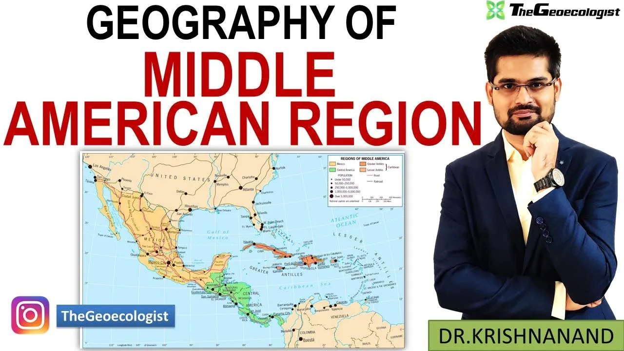
Table of Contents
- Geological Foundations of the Middle American Realm
- Tectonic Setting and Volcanic Activity
- Mountain Systems and Topographic Diversity
- Climatic Zones and Ecological Regions
- Köppen Climate Classification Across the Realm
- Vertical Zonation and Life Zones
- Hydrological Systems and Water Resources
- Major River Basins and Watershed Divides
- Groundwater and Aquifer Systems
- Biodiversity and Conservation Hotspots
- Species Richness and Endemism
- Protected Areas and Conservation Challenges
- Pre-Columbian Civilizations and Human Geography
- Cultural Hearths and Agricultural Origins
- Classic Period Urbanism and Environmental Adaptation
- Post-Classic Empires and the Aztec Triple Alliance
- Colonial Transformations and Modern Political Geography
- Spanish Conquest and Territorial Reorganization
- Independence, Borders, and the Central American Federation
- Contemporary Challenges and Future Trajectories
- Climate Change Vulnerability and Adaptation
- Migration Corridors and Demographic Shifts
- Economic Integration and Infrastructure Development
- Conclusion
Mesoamerica geography encompasses one of the world’s most geologically dynamic and culturally rich regions, stretching from central Mexico through Belize, Guatemala, El Salvador, Honduras, Nicaragua, and Costa Rica. This Middle American realm serves as a critical land bridge connecting North and South America while hosting an extraordinary convergence of tectonic forces, climatic zones, and human civilizations that have shaped global history for millennia.
- Mesoamerica geography spans approximately 1,000,000 km² across seven countries, forming a biodiverse land bridge between continents.
- The region sits atop the Pacific Ring of Fire, driving volcanic activity that created fertile soils supporting ancient civilizations.
- Climate varies dramatically from arid northern deserts to tropical rainforests, creating distinct ecological zones within short distances.
- Major civilizations including the Olmecs, Maya, and Aztecs developed sophisticated agricultural, astronomical, and architectural systems.
- Modern challenges include deforestation, climate change vulnerability, migration pressures, and the strategic importance of the Panama Canal.
Geological Foundations of the Middle American Realm
Tectonic Setting and Volcanic Activity
The Mesoamerica geography is fundamentally defined by its position along the convergent boundary of the Cocos, Caribbean, and North American plates. This tectonic complexity generates the Central American Volcanic Arc, a chain of over 40 active volcanoes extending from Guatemala to Panama. According to the Smithsonian Institution’s Global Volcanism Program, the region experiences frequent seismic events, with major earthquakes occurring approximately every 50-75 years along the Middle America Trench.
Volcanic soils, particularly andosols derived from ash deposits, create exceptionally fertile agricultural land. The Valley of Mexico, Guatemala’s highlands, and Nicaragua’s volcanic zones supported dense pre-Columbian populations through intensive maize cultivation. However, this geological bounty comes with significant risk: the 1985 Mexico City earthquake (magnitude 8.0) killed over 5,000 people, while the 1976 Guatemala earthquake (magnitude 7.5) claimed approximately 23,000 lives.
Mountain Systems and Topographic Diversity
The Sierra Madre mountain system dominates Mesoamerica geography, comprising three parallel ranges: the Sierra Madre Occidental (western), Sierra Madre Oriental (eastern), and Sierra Madre del Sur (southern). These ranges create dramatic elevation gradients, with peaks exceeding 5,000 meters including Pico de Orizaba (5,636 m), Central America’s highest point at Volcán Tajumulco (4,220 m), and numerous summits above 3,000 meters.
This topographic complexity generates the region’s remarkable climatic diversity through orographic effects. Windward slopes receive 2,000-4,000 mm annual rainfall supporting cloud forests, while leeward valleys experience rain shadow effects creating semi-arid conditions. The Mexican Altiplano, a high plateau between the Sierra Madres, sits at 1,800-2,500 meters elevation and hosts major urban centers including Mexico City (2,240 m), Guadalajara (1,566 m), and León (1,800 m).
Climatic Zones and Ecological Regions
Köppen Climate Classification Across the Realm
Mesoamerica geography spans nearly every major climate type within a relatively compact latitudinal range (approximately 7°N to 23°N). The northern reaches feature BWh (hot desert) and BSh (hot semi-arid) climates in the Sonoran and Chihuahuan Deserts. Central Mexico transitions to Cwb (subtropical highland) and Cwa (monsoon-influenced humid subtropical) zones. The Pacific coast exhibits Aw (tropical savanna) and Am (tropical monsoon) patterns, while the Caribbean slope and southern regions transition to Af (tropical rainforest) climates with year-round precipitation exceeding 3,000 mm annually.
Vertical Zonation and Life Zones
The concept of “vertical zonation” or “altitudinal belts” is central to understanding Mesoamerica geography. Alexander von Humboldt’s observations in the early 19th century established the framework still used today: tierra caliente (hot land, 0-1,000 m), tierra templada (temperate land, 1,000-2,000 m), tierra fría (cold land, 2,000-3,500 m), and páramo/alpino zones above 3,500 m. Each zone supports distinct agricultural systems: sugarcane, cacao, and bananas in tierra caliente; coffee, maize, and beans in tierra templada; wheat, barley, and potatoes in tierra fría; and pastoralism in páramo regions.
This vertical diversity compresses ecosystems that would span thousands of kilometers latitudinally into mere tens of kilometers horizontally. The Mesoamerican Biological Corridor initiative recognizes this by connecting protected areas across eight countries to preserve genetic flow between populations.
Hydrological Systems and Water Resources
Major River Basins and Watershed Divides
The Continental Divide runs through the Sierra Madre ranges, creating distinct Pacific and Caribbean/Gulf of Mexico drainage systems. Pacific rivers (Lerma-Santiago, Balsas, Lempa) are generally shorter, steeper, and more seasonal. Caribbean watersheds (Usumacinta, Grijalva, Motagua, Coco) feature longer courses, larger basins, and more consistent flow. The Usumacinta-Grijalva system, draining approximately 112,550 km², represents the region’s largest basin and forms part of the Mexico-Guatemala border.
Lake systems play crucial roles in Mesoamerica geography. Lake Nicaragua (8,264 km²), Central America’s largest freshwater lake, contains unique freshwater sharks and connects to the Caribbean via the San Juan River. Lake Chapala (1,100 km²), Mexico’s largest natural lake, faces severe depletion from agricultural extraction. The Valley of Mexico’s former lake system (Texcoco, Xochimilco, Chalco) was largely drained following Spanish conquest, creating modern Mexico City’s subsidence crisis (up to 30 cm/year in some areas).
Groundwater and Aquifer Systems
The Yucatán Peninsula’s karst topography creates a unique hydrological regime within Mesoamerica geography. The region lacks surface rivers; instead, a vast network of cenotes (sinkholes) and underground rivers formed in permeable limestone provides freshwater access. This system supported Maya civilization through sophisticated water management including chultunes (cisterns) and aguadas (reservoirs). Modern tourism development threatens aquifer quality through contamination and over-extraction, with the Riviera Maya experiencing saltwater intrusion up to 15 km inland.
Biodiversity and Conservation Hotspots
Species Richness and Endemism
Mesoamerica geography ranks among Earth’s 36 recognized biodiversity hotspots, harboring approximately 7-10% of global species on just 0.5% of Earth’s land surface. The region hosts an estimated 17,000-20,000 vascular plant species (2,900+ endemic), 1,100+ bird species (200+ endemic), 500+ mammal species, and 600+ amphibian species. Notable endemics include the resplendent quetzal (Pharomachrus mocinno), Central American spider monkey (Ateles geoffroyi), and numerous salamander genera (Bolitoglossa, Pseudoeurycea) exhibiting remarkable adaptive radiation in cloud forests.
The Mesoamerican Reef, extending 1,000 km from Isla Contoy to the Bay Islands, represents the Western Hemisphere’s largest barrier reef system. Mesoamerica geography supports 65+ stony coral species, 500+ fish species, and critical habitat for endangered marine turtles and manatees. However, coral cover has declined from approximately 30% (1970s) to 15-20% currently due to bleaching events, disease, and nutrient pollution.
Protected Areas and Conservation Challenges
The region contains over 600 protected areas covering approximately 12% of terrestrial territory, including UNESCO World Heritage Sites like the Maya Biosphere Reserve (Guatemala, 21,602 km²), Río Plátano Biosphere Reserve (Honduras, 5,250 km²), and the Monarch Butterfly Biosphere Reserve (Mexico, 562 km²). However, enforcement remains inconsistent. Deforestation rates in the Maya Biosphere Reserve’s buffer zones exceed 1.5% annually, driven by cattle ranching, oil palm expansion, and narcotics trafficking operations that clear landing strips in remote forests.
Pre-Columbian Civilizations and Human Geography
Cultural Hearths and Agricultural Origins
Mesoamerica geography constitutes one of the world’s six independent centers of plant domestication. Archaeological evidence from Guilá Naquitz Cave (Oaxaca) documents maize domestication beginning approximately 9,000 years ago, with teosinte (Zea mays ssp. parviglumis) as the wild progenitor. By 3,000 BCE, maize-bean-squash polyculture (the “Three Sisters” system) supported sedentary villages. Additional domesticates included chili peppers, tomatoes, avocados, cacao, cotton, and agave species.
The Olmec civilization (1600-400 BCE) emerged in the Gulf Coast lowlands, establishing cultural patterns including monumental sculpture, calendar systems, and ballgame traditions that persisted throughout Mesoamerican history. Their heartland at San Lorenzo and La Venta exploited rich alluvial soils and controlled trade networks extending to highland obsidian sources (Pachuca, Otumba) and Pacific coastal cacao zones.
Classic Period Urbanism and Environmental Adaptation
The Maya Classic Period (250-900 CE) represents Mesoamerica geography‘s most sophisticated urban adaptation to tropical forest environments. Cities like Tikal (Guatemala), Calakmul (Mexico), and Caracol (Belize) supported populations of 50,000-100,000 through intensive agricultural systems including raised fields (chinampas), terracing, and reservoir networks. LiDAR surveys since 2016 have revealed unprecedented landscape modification: over 60,000 structures in Guatemala’s Petén region alone, with engineered wetlands covering 1,000+ km².
Teotihuacan (100 BCE-550 CE), located in the Valley of Mexico, reached 100,000-200,000 inhabitants, making Mesoamerica geography the Americas’ largest pre-Columbian city. Its grid plan, aligned 15.5° east of north to celestial markers, controlled obsidian trade from nearby Pachuca and Sierra de las Navajas sources. The city’s collapse around 550 CE correlates with severe drought episodes documented in speleothem records from nearby caves.
Post-Classic Empires and the Aztec Triple Alliance
The Aztec (Mexica) Empire (1428-1521 CE) mastered Mesoamerica geography through a tributary system spanning from the Pacific to Gulf coasts. Tenochtitlan, built on Lake Texcoco’s islands, housed 200,000-300,000 residents supplied by chinampa agriculture producing up to 7 harvests annually. The empire’s strategic control of trade routes moved luxury goods (quetzal feathers, jade, cacao, cotton) from distant provinces to central markets like Tlatelolco, described by Spanish chroniclers as exceeding any European market in scale and organization.
Colonial Transformations and Modern Political Geography
Spanish Conquest and Territorial Reorganization
The Spanish conquest (1519-1697 CE) fundamentally restructured Mesoamerica geography through the encomienda system, congregación (forced resettlement), and introduction of Old World species. Silver mining centers (Zacatecas, Guanajuato, Taxco) redirected economic activity northward, while the Manila Galleon trade (1565-1815) connected Acapulco to Asia, making the Pacific coast a global entrepôt. Colonial administrative units (audiencias, intendancies) established boundaries that largely persist in modern national borders.
Independence, Borders, and the Central American Federation
Following independence from Spain (1821), the Federal Republic of Central America (1823-1841) briefly united Guatemala, El Salvador, Honduras, Nicaragua, and Costa Rica. Its dissolution created the modern state system, though border disputes persisted: the Belize-Guatemala territorial claim (originating from 1859 treaty ambiguities) was only partially resolved in 2019 via ICJ referral. The 1903 Panama separation from Colombia, facilitated by U.S. intervention, created the geopolitical conditions for the Panama Canal, permanently altering global maritime Mesoamerica geography.
Contemporary Challenges and Future Trajectories
Climate Change Vulnerability and Adaptation
Mesoamerica geography faces disproportionate climate impacts despite minimal historical emissions. The IPCC AR6 identifies Central America as a “climate change hotspot” with projected temperature increases of 1.5-3°C by 2050 and precipitation declines of 10-30% in the Dry Corridor (Guatemala, El Salvador, Honduras, Nicaragua). This threatens the region’s 2.2 million smallholder farmers dependent on rainfed maize/bean systems. Hurricane intensity has increased: Category 4-5 landfalls averaged 0.6 per decade (1980-2000) versus 1.8 per decade (2001-2020), with Hurricanes Eta and Iota (November 2020) causing $9.3 billion in damages across Central America.
Migration Corridors and Demographic Shifts
The region functions as both origin and transit zone for one of the world’s largest migration corridors. The U.S. Customs and Border Protection encountered 2.4 million migrants at the Southwest border in FY2023, with 40% originating from the Northern Triangle (Guatemala, Honduras, El Salvador). Remittances constitute 20-25% of GDP for these countries ($31.2 billion to Guatemala alone in 2022). Internal urbanization accelerates: Central America’s urban population grew from 35% (1990) to 60% (2020), creating peri-urban informal settlements on geologically unstable slopes.
Economic Integration and Infrastructure Development
The Central American Integration System (SICA) and the 2023 USMCA renegotiation shape regional economic Mesoamerica geography. The Mesoamerica Integration and Development Project (PM) coordinates 10 member states on infrastructure including the SIEPAC electrical interconnection (1,800 km transmission line), the International Network of Mesoamerican Highways (RICAM), and broadband connectivity initiatives. The Panama Canal’s 2016 expansion (Neopanamax locks) accommodates 98% of global shipping, generating $4.3 billion annual toll revenue (2023) and positioning Panama as a logistics hub.
Conclusion
Mesoamerica geography reveals a region of extraordinary complexity where geological forces, climatic gradients, and human ingenuity have interacted for millennia. From the volcanic soils that nurtured maize domestication to the karst aquifers that sustained Maya cities, from the cloud forests harboring endemic salamanders to the coral reefs buffering Caribbean coastlines, every landscape element tells a story of dynamic equilibrium. Today, this equilibrium faces unprecedented pressures: climate change amplifying hydrological extremes, migration reshaping demographic landscapes, and economic integration reconfiguring spatial relationships.
Understanding Mesoamerica geography requires transcending disciplinary boundaries, integrating plate tectonics with pre-Columbian history, hydrology with modern water governance, and biodiversity conservation with indigenous territorial rights. As the region navigates the 21st century, its geographic literacy becomes not merely an academic pursuit but a practical necessity for policymakers, development practitioners, and communities striving for sustainable futures in one of Earth’s most vibrant and vulnerable realms.
Frequently Asked Questions
Mesoamerica geography encompasses central and southern Mexico, Guatemala, Belize, El Salvador, Honduras, Nicaragua, and Costa Rica. Some definitions also include parts of Panama up to the Darién Gap.
Mesoamerica hosts 7-10% of Earth's species on just 0.5% of land area, with high endemism in cloud forests, coral reefs, and tropical dry forests. It contains over 17,000 plant species and 1,100+ bird species, many found nowhere else.
Volcanic soils enabled intensive maize agriculture supporting dense populations. Mountain ranges created vertical zonation allowing diverse crop production. Karst topography in the Yucatán drove sophisticated water management. Trade routes connected obsidian, jade, cacao, and quetzal feather sources across ecological zones.
